File:Atu feb 21 2011.jpg
跳转到导航
跳转到搜索

本预览的尺寸:459 × 599像素。 其他分辨率:184 × 240像素 | 368 × 480像素 | 588 × 768像素 | 784 × 1,024像素 | 1,569 × 2,048像素 | 7,200 × 9,400像素。
原始文件 (7,200 × 9,400像素,文件大小:8.58 MB,MIME类型:image/jpeg)
说明
说明
添加一行文字以描述该文件所表现的内容
| 警告 | 部分浏览器在浏览此图片的完整大小时可能会遇到困难:该图片中有数量巨大的像素点,可能无法完全载入或者导致您的浏览器停止响应。 |
|---|
摘要
[编辑]
| 描述 |
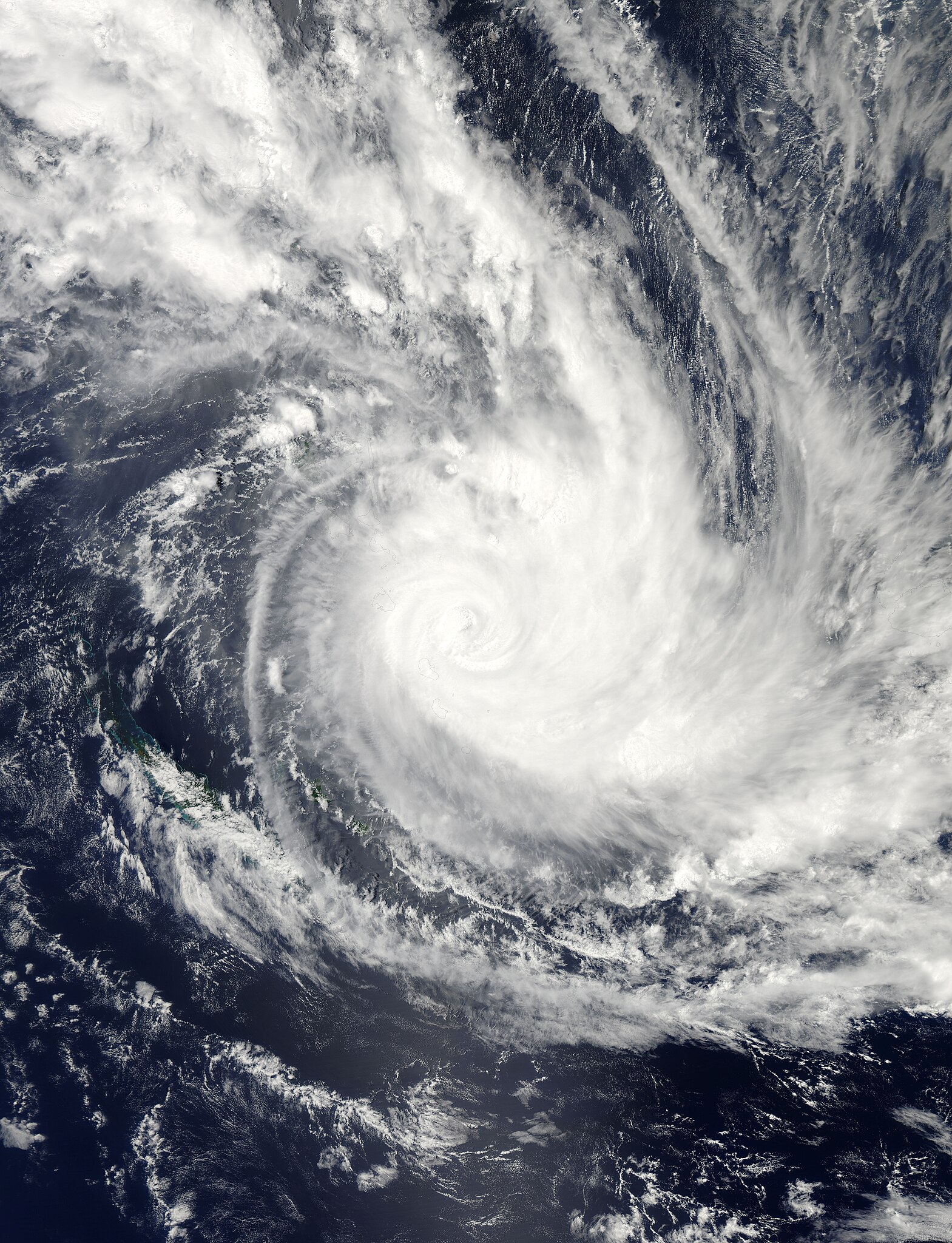
English: Tropical Cyclone Atu raged over the southern Pacific Ocean in late February 2011, stretching from New Caledonia to Fiji. The U.S. Navy’s Joint Typhoon Warning Center (JTWC) reported that, as of 8:00 p.m. local time on February 21, Atu was located roughly 115 nautical miles (215 kilometers) east-southeast of Port Vila, Vanuatu. The storm had maximum sustained winds of 100 knots (185 kilometers per hour) and gusts up to 125 knots (230 kilometers per hour).
The Moderate Resolution Imaging Spectroradiometer (MODIS) on NASA’s Aqua satellite captured this natural-color image around 11:30 a.m. local time on February 21, 2011. The center of the storm appears just east of the Vanuatu archipelago. The JTWC forecast that Atu would accelerate roughly toward the southeast, and would probably intensify slightly over the next 24 hours. After about 36 hours, however, Atu was expected to quickly weaken, thanks to increasing vertical wind shear and lower sea surface temperatures. |
| 日期 | |
| 来源 | http://earthobservatory.nasa.gov/NaturalHazards/view.php?id=49381 |
| 作者 | NASA images courtesy Jeff Schmaltz, MODIS Rapid Response Team at NASA GSFC. Caption by Michon Scott. |
许可协议
[编辑]
| 本文件完全由NASA创作,在美国属于公有领域。根据NASA的版权方针,NASA的材料除非另有声明否则不受版权保护。(参见Template:PD-USGov/zh、NASA版权方针页面或JPL图片使用方针。) | ||
 |
警告:
|
文件历史
点击某个日期/时间查看对应时刻的文件。
| 日期/时间 | 缩略图 | 大小 | 用户 | 备注 | |
|---|---|---|---|---|---|
| 当前 | 2023年8月13日 (日) 13:59 | | 7,200 × 9,400(8.58 MB) | Nino Marakot(留言 | 贡献) | Original image |
| 2011年2月21日 (一) 19:50 |  | 7,200 × 9,400(11.26 MB) | Supportstorm(留言 | 贡献) | {{Information |Description ={{en|1=Tropical Cyclone Atu raged over the southern Pacific Ocean in late February 2011, stretching from New Caledonia to Fiji. The U.S. Navy’s Joint Typhoon Warning Center (JTWC) reported that, as of 8:00 p.m. local time |
您不可以覆盖此文件。
文件用途
没有页面使用本文件。
全域文件用途
以下其他wiki使用此文件:
- en.wikipedia.org上的用途
- ko.wikipedia.org上的用途
- pt.wikipedia.org上的用途
- ru.wikipedia.org上的用途
- zh.wikipedia.org上的用途