File:Auroras over North America.jpg
跳转到导航
跳转到搜索

本预览的尺寸:600 × 600像素。 其他分辨率:240 × 240像素 | 480 × 480像素 | 768 × 768像素 | 1,024 × 1,024像素 | 2,048 × 2,048像素 | 3,677 × 3,677像素。
原始文件 (3,677 × 3,677像素,文件大小:2.05 MB,MIME类型:image/jpeg)
说明
说明
添加一行文字以描述该文件所表现的内容
摘要
[编辑]
| 描述 |
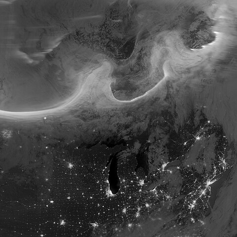
Deutsch: Bild der Aurora borealis vom frühen Morgen des 8. Oktobers 2012, aufgenommen mit dem "Tag-Nacht-Band" (DNB, 505 bis 890 Nanometer – hauptsächlich sichtbares Licht von grün bis nahem ultraviolett) der Visible Infrared Imaging Radiometer Suite (VIIRS) an Bord des Satelliten Suomi National Polar-orbiting Partnership (Suomi NPP). Die Lichter im Bild ziehen sich über die kanadischen Provinzen Quebec und Ontario und sind Teil des Gesamtovals, das sich durch einen geomagnetischen Sturm bis in mittlere Breiten hinab ausdehnte. English: Using the “day-night band” (DNB, 505 to 890 nanometres – primarily visible light from green to near visible infrared) of the Visible Infrared Imaging Radiometer Suite (VIIRS), the Suomi National Polar-orbiting Partnership (Suomi NPP) satellite acquired this view of the aurora borealis early on the morning of October 8, 2012. The northern lights stretch across Canada’s Quebec and Ontario provinces in the image, and are part of the auroral oval that expanded to middle latitudes because of a geomagnetic storm. |
| 日期 | |
| 来源 | NASA Earth Observatory |
| 作者 | Jesse Allen and Robert Simmon |
| 相机位置 | | 在以下服务上查看本图像和附近其他图像: OpenStreetMap |
|---|
| 注解 | 该图片含有注解:在维基媒体共享资源上查看注解 |
许可协议
[编辑]
| 本文件完全由NASA创作,在美国属于公有领域。根据NASA的版权方针,NASA的材料除非另有声明否则不受版权保护。(参见Template:PD-USGov/zh、NASA版权方针页面或JPL图片使用方针。) | ||
 |
警告:
|
文件历史
点击某个日期/时间查看对应时刻的文件。
| 日期/时间 | 缩略图 | 大小 | 用户 | 备注 | |
|---|---|---|---|---|---|
| 当前 | 2012年10月12日 (五) 10:00 | | 3,677 × 3,677(2.05 MB) | Originalwana(留言 | 贡献) | {{Information |Description ={{en|1=Using the “day-night band” (DNB) of the Visible Infrared Imaging Radiometer Suite (VIIRS), the Suomi National Polar-orbiting Partnership (Suomi NPP) satellite acquired this view of the aurora borealis early on ... |
您不可以覆盖此文件。
文件用途
以下2个页面使用本文件:
.jpg&redirect=no)
全域文件用途
以下其他wiki使用此文件:
- et.wikipedia.org上的用途
- fr.wikipedia.org上的用途
- id.wikipedia.org上的用途
- sk.wikipedia.org上的用途
- zh.wikipedia.org上的用途