File:Australia.A2002231.0145.250m NASA Nullarbor.jpg

原始檔案 (5,800 × 4,400 像素,檔案大小:2.91 MB,MIME 類型:image/jpeg)
說明
說明
摘要
[編輯]
- Credit Jacques Descloitres, MODIS Rapid Response Team, NASA/GSFC
http://visibleearth.nasa.gov/view_rec.php?id=4153 archive copy at the Wayback Machine
Metadata Sensor Terra/MODIS Datastart 2002-08-19 Dataend 2002-08-19 Visible Earth v1 ID 21116 Visualization Date 2002-09-16
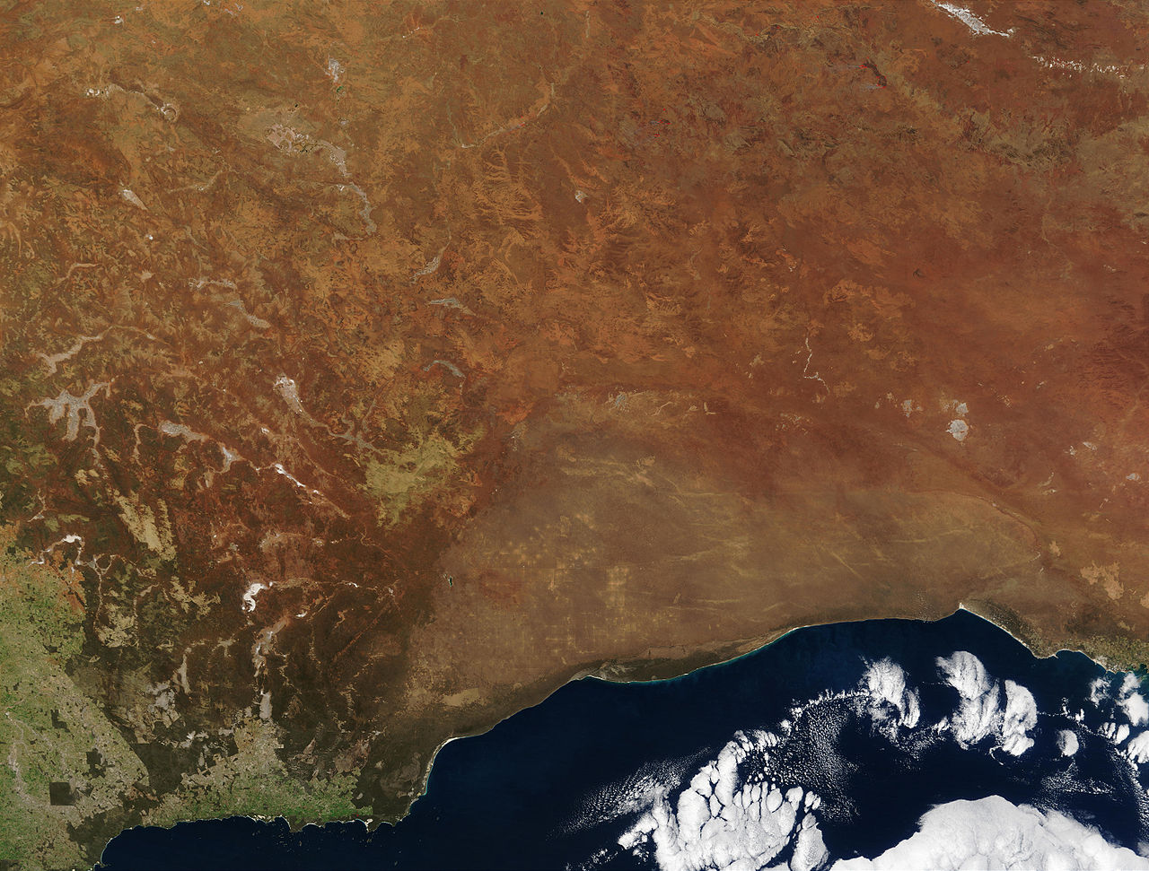
"The striking orange-red colored southern Australian coast contrasts against the deep sapphire-blue waters of the Southern Ocean in this true-color Moderate Resolution Imaging Spectroradiometer (MODIS) image acquired by the Terra satellite on August 19, 2002. In the northern portion of the image, a handful of fires (marked in red) were detected burning in the Great Victoria Desert by the MODIS instrument. South of the desert is the lighter-orange Nullarbor Plain, which stretches for over 1000 kilometers (about 600 miles) from end to end. Finally, just off the coast in the Southern Ocean is the Great Australian Bight, home to Australian Sea Lions, Southern Right Whales, and various fish species."
| 本作品由NASA創作,屬於公有領域。根據NASA的版權政策:“NASA的創作除非另有聲明否則不受版權保護。”(參見:Template:PD-USGov/zh,NASA版權政策或JPL圖像使用政策) | ||
 |
警告:
|
en:Image:Australia.A2002231.0145.250m_NASA_Nullarbor.jpg
授權條款
[編輯]
| 此檔案採用創用CC 姓名標示-相同方式分享 3.0 未在地化版本授權條款。 受免責聲明的約束。 | ||
| ||
| 已新增授權條款標題至此檔案,作為GFDL授權更新的一部份。 |

|
已授權您依據自由軟體基金會發行的無固定段落、封面文字和封底文字GNU自由文件授權條款1.2版或任意後續版本,對本檔進行複製、傳播和/或修改。該協議的副本列在GNU自由文件授權條款中。 受免責聲明的約束。 |
檔案歷史
點選日期/時間以檢視該時間的檔案版本。
| 日期/時間 | 縮圖 | 尺寸 | 使用者 | 備註 | |
|---|---|---|---|---|---|
| 目前 | 2005年10月24日 (一) 20:27 | | 5,800 × 4,400(2.91 MB) | Albinfo(留言 | 貢獻) | *Credit Jacques Descloitres, MODIS Rapid Response Team, NASA/GSFC http://visibleearth.nasa.gov/view_rec.php?id=4153 Metadata Sensor Terra/MODIS Datastart 2002-08-19 Dataend 2002-08-19 Visible Earth v1 ID 21116 Visualization Date 2002-09-16 "The |
無法覆蓋此檔案。
檔案用途
全域檔案使用狀況
以下其他 wiki 使用了這個檔案:
- af.wikipedia.org 的使用狀況
- an.wikipedia.org 的使用狀況
- ar.wikipedia.org 的使用狀況
- arz.wikipedia.org 的使用狀況
- ast.wikipedia.org 的使用狀況
- avk.wikipedia.org 的使用狀況
- az.wikipedia.org 的使用狀況
- ba.wikipedia.org 的使用狀況
- be-tarask.wikipedia.org 的使用狀況
- be.wikipedia.org 的使用狀況
- bg.wikipedia.org 的使用狀況
- bn.wikipedia.org 的使用狀況
- ca.wikipedia.org 的使用狀況
- ceb.wikipedia.org 的使用狀況
- cy.wikipedia.org 的使用狀況
- da.wikipedia.org 的使用狀況
- de.wikipedia.org 的使用狀況
- en.wikipedia.org 的使用狀況
- en.wikiversity.org 的使用狀況
- en.wikivoyage.org 的使用狀況
- eo.wikipedia.org 的使用狀況
- es.wikipedia.org 的使用狀況
- es.wikivoyage.org 的使用狀況
- eu.wikipedia.org 的使用狀況
- fa.wikipedia.org 的使用狀況
- fi.wikipedia.org 的使用狀況
- frr.wikipedia.org 的使用狀況
檢視此檔案的更多全域使用狀況。