File:Austria satellite-map.jpg

Datoteca originala (2.550 × 1.381 pixels, grondezza da datoteca: 1,22 MB, tip da MIME: image/jpeg)
Bildtexte
Kurzbeschreibungen
Resumaziun[modifitgar]
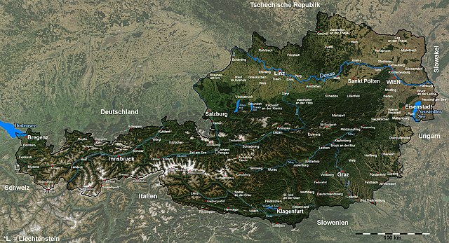
| Descripziun | Satellite image of Austria with provincial capitals and other annotations |
| Data | |
| Funtauna |
The image is based on a satellite image from [1]. Original image: Credit Jeff Schmaltz, MODIS Rapid Response Team, NASA/GSFC. |
| Autur | Michael Schmid |
| permissiun (Weiternutzung dieser Datei) |
Based on a NASA image, thus in the public domain. |
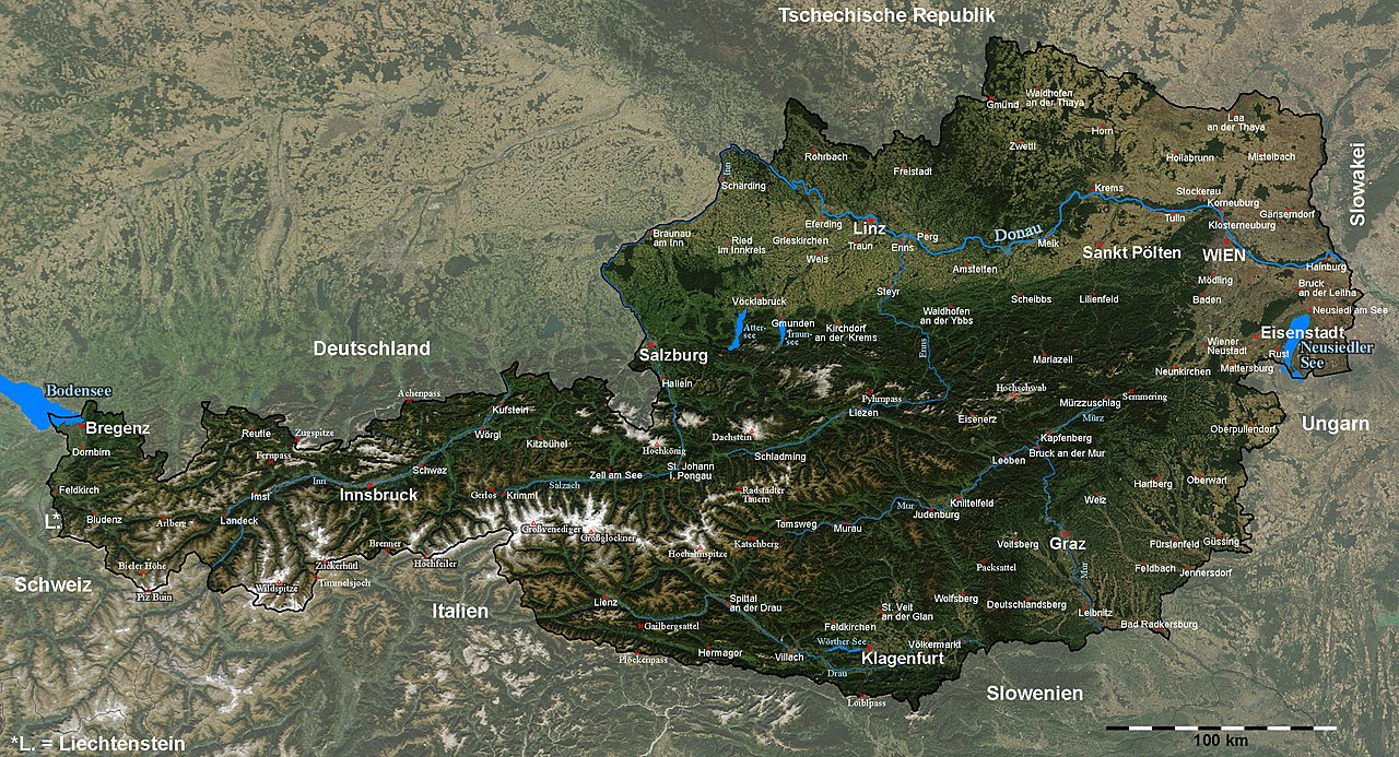
| Andere Versionen | Image:Austria_satellite_unannotated.jpg with no annotations except dots at the positions of a few cities, Image:Austria_satellite_annotated.jpg with some limited annotations. |
![[1]](http://visibleearth.nasa.gov/images/5947/Italy.A2003262.1005.250m.jpg)
I have marked and labelled quite a lot of places with the help of the NASA Worldwind software and several maps. It was quite some work, but also a nice exercise in geography for me ;-).
Unless I have forgotten something, the map shows (among other cities) the capitals of all districts and provinces of Austria.
Please note: The cities of Wien (Vienna) and Linz were marked a few kilometers from their actual locations in the original satellite image; this has been corrected here.[2].
Das Bild wurde in y-Richtung um ca. 5% gestreckt, um eine wenig verzerrte Karte zu erhalten. Um Österreich hervorzuheben, habe ich den Kontrast außerhalb der Grenzen Österreichs reduziert und die Grenzlinie dicker eingezeichnet, und danach durch Vergleich mit der NASA Worldwind Software und diversen Karten die Positionen diverser Orte, Berge und Pässe bestimmt und eingezeichnet.
Die Karte enthält (wenn ich keine vergessen habe) unter anderem alle Landes- und Bezirkshauptstädte Österreichs.Licenza[modifitgar]
| Diese Datei ist gemeinfrei (public domain), da sie von der NASA erstellt worden ist. Die NASA-Urheberrechtsrichtlinie besagt, dass „NASA-Material nicht durch Urheberrecht geschützt ist, wenn es nicht anders angegeben ist“. (NASA-Urheberrechtsrichtlinie-Seite oder JPL Image Use Policy). | ||
 |
Warnung:
|
Istorgia da las versiuns
Clicca sin ina data/temps per vesair la versiun da lura.
| data/temp | Maletg da prevista | dimensiuns | Utilisader | commentari | |
|---|---|---|---|---|---|
| actual | 19:41, 11. sett 2005 | | 2.550 × 1.381 (1,22 MB) | Schmid (Discussiun | contribuziuns) | {{Information| |Description = Satellite image of Austria with provincial capitals and other annotations | Source = The image is based on a satellite image from [http://visibleearth.nasa.gov/images/5947/Italy.A2003262.1005.250m.jpg]. Original image: Cre |
Ti na pos betg sursvriver questa datoteca.
Utilisaziun da la datoteca
Las suandantas 2 paginas èn colliadas cun questa datoteca:
Diever da datoteca global
Die nachfolgenden anderen Wikis verwenden diese Datei:
- Utilisaziun sin af.wikipedia.org
- Utilisaziun sin cs.wikipedia.org
- Utilisaziun sin da.wikipedia.org
- Utilisaziun sin de.wikipedia.org
- Utilisaziun sin en.wikipedia.org
- Utilisaziun sin fr.wikipedia.org
- Utilisaziun sin hu.wikipedia.org
- Utilisaziun sin hy.wikipedia.org
- Utilisaziun sin hyw.wikipedia.org
- Utilisaziun sin ku.wikipedia.org
- Utilisaziun sin nn.wikipedia.org
- Utilisaziun sin no.wikipedia.org
- Utilisaziun sin rm.wikipedia.org
- Utilisaziun sin ru.wikipedia.org
- Utilisaziun sin sk.wikipedia.org
- Utilisaziun sin tl.wikipedia.org
- Utilisaziun sin tr.wikipedia.org
- Utilisaziun sin uk.wikipedia.org