File:Aztec Empire 1519 map-pt.svg
跳转到导航
跳转到搜索

此SVG文件的PNG预览的大小:778 × 599像素。 其他分辨率:312 × 240像素 | 623 × 480像素 | 997 × 768像素 | 1,280 × 986像素 | 2,560 × 1,972像素 | 1,898 × 1,462像素。
原始文件 (SVG文件,尺寸为1,898 × 1,462像素,文件大小:306 KB)
说明
说明
添加一行文字以描述该文件所表现的内容
摘要
[编辑]| 描述 |
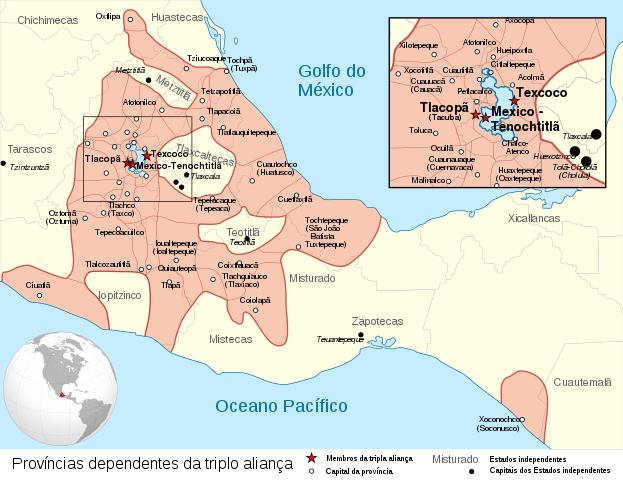
Español: Provincias tributarias de la Triple Alianza encabezada por Tenochtitlan antes de la llegada de los españoles en 1519.
English: Map of the Aztec Empire lead by Tenochtitlan circa 1519, before the arrival of the Spanish.
Français : Étendue de l'empire Aztèque soumis à la Triple Alliance, dirigée par Tenochtitlan, à l'arrivée des Espagnols en 1519. |
| 日期 | (UTC) |
| 来源 |
|
| 作者 | |
| 其他版本 |
[] Detailed maps[编辑]
Simple maps[编辑]
|
| SVG开发 |


.svg)
.svg)
.svg)
| 相机位置 | | 在以下服务上查看本图像和附近其他图像: OpenStreetMap |
|---|
许可协议
[编辑]
本文件采用知识共享署名-相同方式共享 3.0 未本地化版本许可协议授权。
- 您可以自由地:
- 共享 – 复制、发行并传播本作品
- 修改 – 改编作品
- 惟须遵守下列条件:
- 署名 – 您必须对作品进行署名,提供授权条款的链接,并说明是否对原始内容进行了更改。您可以用任何合理的方式来署名,但不得以任何方式表明许可人认可您或您的使用。
- 相同方式共享 – 如果您再混合、转换或者基于本作品进行创作,您必须以与原先许可协议相同或相兼容的许可协议分发您贡献的作品。
原始上传日志
[编辑]
This image is a derivative work of the following images:
- File:Provincias_tributarias_de_la_Triple_Alianza_(s._XVI).svg licensed with Cc-by-sa-3.0-migrated, FAL, GFDL
- 2008-12-13T03:29:16Z Yavidaxiu 949x731 (878329 Bytes) {{Information |Description={{es|1=Provincias tributarias de la Triple Alianza encabezada por Tenochtitlan antes de la llegada de los españoles. Fuente: ''Atlas del México prehispánico'', edición especial de ''Arqueología
- File:Aztec_Empire_(orthographic_projection).svg licensed with Cc-by-sa-3.0, GFDL
- 2010-02-11T12:23:41Z Sémhur 550x550 (104628 Bytes) Update with data from a sourced map.
- 2010-01-10T20:34:52Z Keepscases 550x550 (284361 Bytes) {{Information |Description={{en|1=Aztec Empire (orthographic projection)}} |Source={{own}} |Author=[[User:Keepscases|Keepscases]] |Date= |Permission= |other_versions= }} [[Category:SVG - Orthographic projections]]
Uploaded with derivativeFX
文件历史
点击某个日期/时间查看对应时刻的文件。
| 日期/时间 | 缩略图 | 大小 | 用户 | 备注 | |
|---|---|---|---|---|---|
| 当前 | 2019年2月16日 (六) 05:20 | | 1,898 × 1,462(306 KB) | Renato de Carvalho Ferreira(留言 | 贡献) | Ajustes |
| 2011年2月8日 (二) 00:09 |  | 1,898 × 1,462(307 KB) | Eddo(留言 | 贡献) | {{Information |Description ={{en|1=Map of the Aztec Empire lead by Tenochtitlan circa 1519, before the arrival of the Spanish.}} |Source ={{own}} |Author =Eddo |Date = |Permission = |othe |
您不可以覆盖此文件。
文件用途
以下11个页面使用本文件:
- File:Az Azték Birodalom 1519-ben.png
- File:Aztec Empire 1519 map-fr.svg
- File:Aztec Empire 1519 map-hu.svg
- File:Aztec Empire 1519 map-pt.svg
- File:Aztec Empire 1519 map-zh-cn.svg
- File:Aztec Empire c 1519.png
- File:Aztec empire 1519-el.svg
- File:Aztec empire 1519-fr.svg
- File:Aztec empire 1519-mk.svg
- File:Aztec empire 1519-nl.svg
- Template:Other versions/Map Aztec Empire 1519
全域文件用途
以下其他wiki使用此文件:
- kn.wikipedia.org上的用途
- pt.wikipedia.org上的用途