File:BC Ferries Zone Two.png
跳转到导航
跳转到搜索

本预览的尺寸:761 × 600像素。 其他分辨率:305 × 240像素 | 609 × 480像素 | 1,002 × 790像素。
原始文件 (1,002 × 790像素,文件大小:1.13 MB,MIME类型:image/png)
说明
说明
添加一行文字以描述该文件所表现的内容
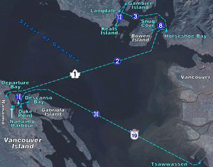
BC Ferry routes in the region of Central Georgia Strait. Map background from NASA World Wind, route diagram self-created.
| 我,本作品著作权人,释出本作品至公有领域。这适用于全世界。 在一些国家这可能不合法;如果是这样的话,那么: 我无条件地授予任何人以任何目的使用本作品的权利,除非这些条件是法律规定所必需的。 |
文件历史
点击某个日期/时间查看对应时刻的文件。
| 日期/时间 | 缩略图 | 大小 | 用户 | 备注 | |
|---|---|---|---|---|---|
| 当前 | 2006年4月18日 (二) 00:39 | | 1,002 × 790(1.13 MB) | Denelson83(留言 | 贡献) | BC Ferry routes in the region of Central Georgia Strait. Map background from w:NASA World Wind, route diagram self-created. {{PD-self}} Category:Maps of British Columbia |
您不可以覆盖此文件。
文件用途
没有页面使用本文件。
全域文件用途
以下其他wiki使用此文件:
- de.wikipedia.org上的用途
- en.wikipedia.org上的用途
- zh.wikipedia.org上的用途