File:BC Ferries Zone Two.png
跳至導覽
跳至搜尋

預覽大小:761 × 600 像素。 其他解析度:305 × 240 像素 | 609 × 480 像素 | 1,002 × 790 像素。
原始檔案 (1,002 × 790 像素,檔案大小:1.13 MB,MIME 類型:image/png)
說明
說明
添加單行說明來描述出檔案所代表的內容
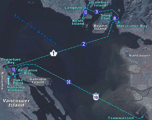
BC Ferry routes in the region of Central Georgia Strait. Map background from NASA World Wind, route diagram self-created.
| 我,此作品的版權所有人,釋出此作品至公共領域。此授權條款在全世界均適用。 這可能在某些國家不合法,如果是的話: 我授予任何人有權利使用此作品於任何用途,除受法律約束外,不受任何限制。 |
檔案歷史
點選日期/時間以檢視該時間的檔案版本。
| 日期/時間 | 縮圖 | 尺寸 | 使用者 | 備註 | |
|---|---|---|---|---|---|
| 目前 | 2006年4月18日 (二) 00:39 | | 1,002 × 790(1.13 MB) | Denelson83(留言 | 貢獻) | BC Ferry routes in the region of Central Georgia Strait. Map background from w:NASA World Wind, route diagram self-created. {{PD-self}} Category:Maps of British Columbia |
無法覆蓋此檔案。
檔案用途
沒有使用此檔案的頁面。
全域檔案使用狀況
以下其他 wiki 使用了這個檔案:
- de.wikipedia.org 的使用狀況
- en.wikipedia.org 的使用狀況
- zh.wikipedia.org 的使用狀況