File:BLR-LTU-POL-RUS.svg
出自Wikimedia Commons
跳至導覽
跳至搜尋

此 SVG 檔案的 PNG 預覽的大小:440 × 407 像素。 其他解析度:259 × 240 像素 | 519 × 480 像素 | 830 × 768 像素 | 1,107 × 1,024 像素 | 2,214 × 2,048 像素。
原始檔案 (SVG 檔案,表面大小:440 × 407 像素,檔案大小:310 KB)
檔案資訊
結構化資料
說明
說明
添加單行說明來描述出檔案所代表的內容
| 描述BLR-LTU-POL-RUS.svg |
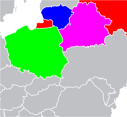
English: SVG map of eastern Europe highlighting Belarus (magenta), Lithuania (blue), Poland (green), and Russia (red). |
| 日期 | (UTC) |
| 來源 | |
| 作者 |
|
| 這是一張修飾過的圖片,即本圖片是用軟體修改過後的版本,修改的方式或內容有:Cropped and highlighed like en:File:BLR-LTU-POL-RUS.png. Some but not all hidden countries removed。原版圖片來源:Location European nation states.svg。修改者:Ken g6。
|
我,本作品的著作權持有者,決定用以下授權條款發佈本作品:
| 此檔案採用共享創意 姓名標示-相同方式分享 3.0 未在地化版本授權條款。 | ||
| ||
| 已新增授權條款標題至此檔案,作為GFDL授權更新的一部份。http://creativecommons.org/licenses/by-sa/3.0/CC BY-SA 3.0Creative Commons Attribution-Share Alike 3.0truetrue |

|
已授權您依據自由軟體基金會發行的無固定段落、封面文字和封底文字GNU自由文件授權條款1.2版或任意後續版本,對本檔進行複製、傳播和/或修改。該協議的副本列在GNU自由文件授權條款中。http://www.gnu.org/copyleft/fdl.htmlGFDLGNU Free Documentation Licensetruetrue |
您可以選擇您需要的授權條款。
原始上傳日誌
[編輯]This image is a derivative work of the following images:
- File:Location_European_nation_states.svg licensed with Cc-by-sa-3.0-migrated, GFDL
- 2010-10-09T15:55:16Z LX 2045x1720 (748293 Bytes) Reverted sockpuppet edits to version as of 15:03, 11 November 2009
- 2010-10-02T06:27:34Z Lartyo 2045x1720 (730891 Bytes) Reverted to version as of 20:37, 18 October 2009
- 2009-11-11T15:03:57Z NuclearVacuum 2045x1720 (748293 Bytes) minor
- 2009-11-11T14:59:54Z NuclearVacuum 2045x1720 (733426 Bytes) territorial fixes
- 2009-10-18T20:37:51Z NuclearVacuum 2045x1720 (730891 Bytes) several countries did not include all its territories
- 2008-12-04T00:44:42Z Ssolbergj 2045x1720 (726069 Bytes) Kosovo
- 2008-06-20T13:09:36Z Ssolbergj 2045x1720 (724181 Bytes) Reverted to version as of 00:57, 12 June 2008
- 2008-06-19T17:59:14Z Ssolbergj 2045x1720 (719110 Bytes) {{Information |Description= |Source= |Date= |Author= |Permission= |other_versions= }}
- 2008-06-12T00:57:39Z Ssolbergj 2045x1720 (724181 Bytes) {{Information |Description={{en|1=SVG map of Europe. Borders of nation states.}} {{no|1=SVG-kart over Europa. Nasjonstatlige grenser.}} |Source=[[:Image:Location Spain EU Europe 1.svg]] |Author=[[:en:User:Ssolbergj|Ssolbergj]
Uploaded with derivativeFX
檔案歷史
點選日期/時間以檢視該時間的檔案版本。
| 日期/時間 | 縮圖 | 尺寸 | 用戶 | 備註 | |
|---|---|---|---|---|---|
| 目前 | 2011年2月4日 (五) 20:38 |  | 440 × 407(310 KB) | Ken g6(對話 | 貢獻) | {{Information |Description={{en|1=SVG map of eastern Europe highlighting Belarus (magenta), Lithuania (blue), Poland (green), and Russia (red).}} |Source=*File:Location_European_nation_states.svg |Date=2011-02-04 20:36 (UTC) |Author=*[[:File:Locatio |
無法覆蓋此檔案。
檔案用途
沒有使用此檔案的頁面。