File:Babylone 1.PNG
跳转到导航
跳转到搜索

本预览的尺寸:800 × 559像素。 其他分辨率:320 × 224像素 | 640 × 447像素 | 982 × 686像素。
原始文件 (982 × 686像素,文件大小:960 KB,MIME类型:image/png)
说明
说明
添加一行文字以描述该文件所表现的内容
| 描述 |
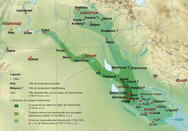
English: Map of the kingdom of the First Dynasty of Babylon from the beginning of the reign of Hammurabi (1792-1750 BC according to middle chronology) to the fall of Babylon in 1595 BC. The maximal extension of the kingdom under the reigns of Hammrabi and his son Samsu-iluna includes cities that have been taken by those kings, but probably dominated at best a few years, like Tuttul, Nineveh and Shekhna. The domination of Terqa by the successors of Samsu-iluna is probable because of some of them appear in the name years of tablets excavated there (Ammi-saduqa, Samsu-ditana). Français : Carte du royaume de la Première dynastie de Babylone depuis le début du règne de Hammurabi (1792-1750 av. J.-C. selon la chronologie moyenne) jusqu'à la chute de Babylone en 1595. L'extension maximale du royaume sous les règnes de Hammurabi et Samsu-iluna inclut des villes qui ont été dominées au mieux quelques années comme Tuttul, Ninive ou Shekhna. La domination de Terqa sous les successeurs de Samsu-iluna est probable du fait de l'utilisation du nom de certains d'entre eux pour dater des tablettes exhumées sur ce site (Ammi-saduqa, Samsu-ditana). |
| 日期 | (UTC) |
| 来源 | |
| 作者 |
|
| 其他版本 |
 |
| 这是一张修改过的图片,这意味着它已在原版本的基础上通过软件进行了编辑,改动内容:Extension du royaume, villes, légende.。其原始版本为:Near East topographic map-blank.svg。修改者:Zunkir。
|
我,本作品著作权人,特此采用以下许可协议发表本作品:
- 您可以自由地:
- 共享 – 复制、发行并传播本作品
- 修改 – 改编作品
- 惟须遵守下列条件:
- 署名 – 您必须对作品进行署名,提供授权条款的链接,并说明是否对原始内容进行了更改。您可以用任何合理的方式来署名,但不得以任何方式表明许可人认可您或您的使用。
- 相同方式共享 – 如果您再混合、转换或者基于本作品进行创作,您必须以与原先许可协议相同或相兼容的许可协议分发您贡献的作品。

|
已授权您依据自由软件基金会发行的无固定段落及封面封底文字(Invariant Sections, Front-Cover Texts, and Back-Cover Texts)的GNU自由文件许可协议1.2版或任意后续版本的条款,复制、传播和/或修改本文件。该协议的副本请见“GNU Free Documentation License”。 |
您可以选择您需要的许可协议。
原始上传日志[编辑]
This image is a derivative work of the following images:
- File:Near_East_topographic_map-blank.svg licensed with Cc-by-sa-3.0,2.5,2.0,1.0, GFDL
- 2009-08-18T18:31:37Z Sémhur 2425x1581 (2442670 Bytes) 3 - New try
- 2009-08-17T15:39:22Z Sémhur 2425x1581 (1815374 Bytes) 2 - With the background...
- 2009-08-17T15:37:36Z Sémhur 2425x1581 (2836 Bytes) {{Information |Description={{en|1=Blank physical map of the [[:en:Near East|Near East]]}} {{fr|1=Carte physique vierge du [[:fr:Proche-Orient|Proche-Orient]].}} |Source={{own}} |Author=[[User:Sémhur|Sémhur]] |Date=2008-08-1
Uploaded with derivativeFX
文件历史
点击某个日期/时间查看对应时刻的文件。
| 日期/时间 | 缩略图 | 大小 | 用户 | 备注 | |
|---|---|---|---|---|---|
| 当前 | 2010年9月29日 (三) 16:16 | | 982 × 686(960 KB) | Zunkir(留言 | 贡献) | {{Information |Description={{en|1=Map of the kigdom of the First Dynasty of Babylon from the beginning of the reign of Hammurabi (1792-1750 BC according to middle chronology) to the fall of Babylon in 1595 BC. The maximal extension of the kigdom under the |
您不可以覆盖此文件。
文件用途
以下页面使用本文件:
全域文件用途
以下其他wiki使用此文件:
- am.wikipedia.org上的用途
- ar.wikipedia.org上的用途
- arz.wikipedia.org上的用途
- bn.wikipedia.org上的用途
- ca.wikipedia.org上的用途
- ceb.wikipedia.org上的用途
- cs.wikipedia.org上的用途
- de.wikipedia.org上的用途
- en.wikipedia.org上的用途
- fa.wikipedia.org上的用途
- fi.wikipedia.org上的用途
- fr.wikipedia.org上的用途
- Antiquité
- XVIIIe siècle av. J.-C.
- Ninive
- Hammurabi
- Histoire de l'Irak
- Code de Hammurabi
- Samsu-iluna
- Liste des souverains de Babylone
- Histoire de la Mésopotamie
- Babylone (civilisation)
- Proche-Orient ancien
- Utilisateur:Zunkir/POA autres
- Utilisateur:Zunkir/cartothèque
- Première dynastie de Babylone
- Littérature irakienne
- id.wikipedia.org上的用途
- incubator.wikimedia.org上的用途
- ja.wikipedia.org上的用途
- ko.wikipedia.org上的用途
查看本文件的更多全域用途。