File:Bagua Plateau on Worldwind.png
跳至導覽
跳至搜尋
預覽大小:315 × 598 像素。 其他解析度:126 × 240 像素 | 358 × 680 像素。
原始檔案 (358 × 680 像素,檔案大小:609 KB,MIME 類型:image/png)
說明
說明
添加單行說明來描述出檔案所代表的內容
摘要[編輯]
| 描述 |
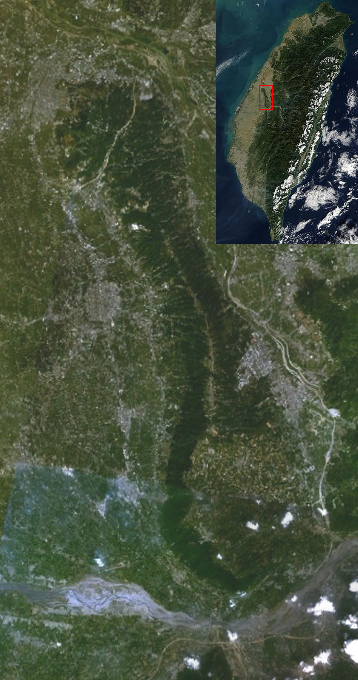
English: Bagua Plateau.It's from a screenshot of NASA World Wind.
中文(繁體):八卦台地衛星空照圖,取自 NASA World Wind。 |
| 來源 | File:Taichung Basin on Worldwind.png |
| 作者 | NASA Ames Research Center |
授權條款[編輯]
| 本圖像屬於公有領域,因其為NASA的World Wind衛星地圖瀏覽器的一張截圖,且使用了公有領域圖層,如Blue Marble、MODIS、Landsat、SRTM、USGS、GLOBE等。
|
 |
| 註解 | 該圖片含有註解:在維基媒體共享資源上查看註解 |
檔案歷史
點選日期/時間以檢視該時間的檔案版本。
| 日期/時間 | 縮圖 | 尺寸 | 用戶 | 備註 | |
|---|---|---|---|---|---|
| 目前 | 2011年5月6日 (五) 19:36 | | 358 × 680(609 KB) | Yiken(對話 | 貢獻) | |
| 2011年4月17日 (日) 15:48 |  | 358 × 680(458 KB) | Yiken(對話 | 貢獻) | {{Information |Description ={{en|1=Bagua Plateau.It's from a screenshot of NASA World Wind.}} {{zh-hant|1=八卦台地衛星空照圖,取自 NASA World Wind。}} |Source =[[:File:Taichung Basin on Worldwind.png|File:Taichung Basin on Worldwin |
無法覆蓋此檔案。
檔案用途
沒有使用此檔案的頁面。
全域檔案使用狀況
以下其他 wiki 使用了這個檔案:
- en.wikipedia.org 的使用狀況
- www.wikidata.org 的使用狀況
- zh-min-nan.wikipedia.org 的使用狀況
- zh.wikipedia.org 的使用狀況