File:Bairisches Mundartgebiet.PNG
Salta a la navegació
Salta a la cerca
Mida d'aquesta previsualització: 800 × 505 píxels. Altres resolucions: 320 × 202 píxels | 640 × 404 píxels | 1.031 × 651 píxels.
Fitxer original (1.031 × 651 píxels, mida del fitxer: 43 Ko, tipus MIME: image/png)
Llegendes
Llegendes
Afegeix una explicació d'una línia del que representa aquest fitxer

|
Aquesta imatge (de tipus linguistic map) s'hauria de tornar a crear utilitzant gràfics vectorials com ara un fitxer SVG. Això té diversos avantatges; en trobareu més informació a Commons:Media for cleanup. Si ja disposeu d'una versió d'aquesta imatge en format SVG, us preguem que la pengeu; després, reemplaceu aquesta plantilla amb la plantilla {{Vector version available|nom nou de la imatge.svg}} en aquesta imatge.
|
Resum[modifica]
العربية (ar): انتشار اللهجات البافارية الحديثة:
البافارية الشمالية (البالانتية العليا).
البافارية الوسطى (البافارية الدانوبية).
البافارية الجنوبية (البافارية الألبية).
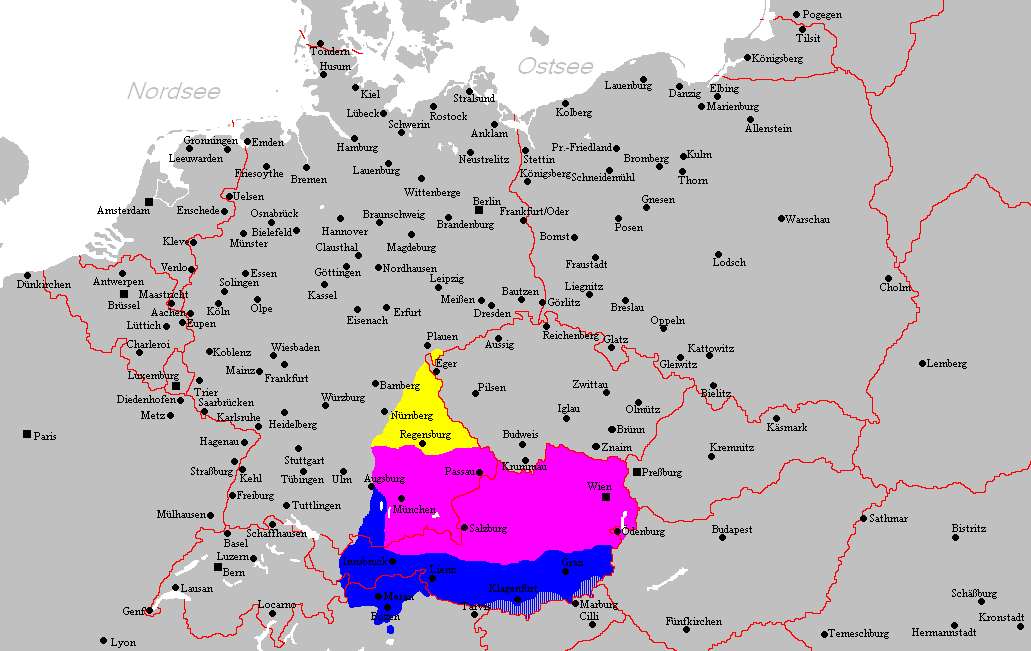
Deutsch (de): Verbreitungsgebiet der heutigen bairischen Mundarten
Nordbairisch
Mittel- oder Donaubairisch
Südbairisch
English (en): Prevalence of modern Bavarian dialects
North Bavarian
Central or Danube Bavarian
South Bavarian
русский (ru): Современные ареалы распространения баварских диалектов
жёлтый: северо-баварский
розовый: среднебаварский (австро (дунайско)-баварский)
синий: южно-баварский
español (es): Distribución del Bavariano.
Baviera del Norte
Baviera central o del Danubio
Baviera del Sur
- design by: Postmann Michael
- Quelle: Selbst erstellt.
- Hinweis: Nach den Vorgaben des "Der Fischer-Informationsatlas der Bundesrepublik Deutschland" (ISBN 3-596-24556-4 Invalid ISBN) von 1990 (S. 63) selbst erstellt. Es wurde sowohl die Karte Westmitteleuropas als auch das bayrische Sprachgebiet vom Autor händisch erstellt. Diese Karte ist gemeinfrei und darf von jedermann verwendet werden!
- Source: Self-made.
- Notes: Information derived from "The Fischer Information Atlas of the Federal Republic of Germany" (ISBN 3-596-24556-4 Invalid ISBN) from 1990 (P. 63). Both the map of west Central Europe and the Bavarian language area were by hand provided by the author. This map is in the public domain and may be used by everyone!
Llicència[modifica]
| S'ha alliberat aquesta obra al domini públic pel seu autor Postmann Michael. Això s'aplica a tot el món. En alguns països això pot no ser legalment possible, en tal cas: |
Historial del fitxer
Cliqueu una data/hora per veure el fitxer tal com era aleshores.
| Data/hora | Miniatura | Dimensions | Usuari/a | Comentari | |
|---|---|---|---|---|---|
| actual | 21:22, 18 feb 2012 | | 1.031 × 651 (43 Ko) | Buachamer (discussió | contribucions) | Sechsämterland und Südvogtland hinzugefügt (siehe http://bar.wikipedia.org/wiki/Datei:Bairischer_Sprachraum2.PNG) |
| 17:56, 12 abr 2009 |  | 1.031 × 651 (57 Ko) | Altaileopard (discussió | contribucions) | Nürnberg aus dem bayerischen Dialektraum entfernt. | |
| 04:10, 2 març 2006 |  | 1.031 × 651 (57 Ko) | Postmann Michael~commonswiki (discussió | contribucions) |
No podeu sobreescriure aquest fitxer.
Ús del fitxer
No hi ha pàgines que utilitzin aquest fitxer.
Ús global del fitxer
Utilització d'aquest fitxer en altres wikis:
- Utilització a als.wikipedia.org
- Utilització a ar.wikipedia.org
- Utilització a ast.wikipedia.org
- Utilització a be-tarask.wikipedia.org
- Utilització a be.wikipedia.org
- Utilització a bg.wikipedia.org
- Utilització a br.wikipedia.org
- Utilització a ca.wikipedia.org
- Utilització a cs.wikipedia.org
- Utilització a da.wikipedia.org
- Utilització a de.wikipedia.org
- Utilització a de.wiktionary.org
- Utilització a en.wikipedia.org
- Utilització a es.wikipedia.org
- Utilització a et.wikipedia.org
- Utilització a eu.wikipedia.org
- Utilització a fa.wikipedia.org
- Utilització a fr.wikipedia.org
- Utilització a fy.wikipedia.org
- Utilització a ga.wikipedia.org
- Utilització a hak.wikipedia.org
- Utilització a he.wikipedia.org
- Utilització a id.wikipedia.org
- Utilització a incubator.wikimedia.org
- Utilització a it.wikipedia.org
Vegeu més usos globals d'aquest fitxer.