File:Balkans850-it.svg
Ir a la navegación
Ir a la búsqueda

Tamaño de esta previsualización PNG del archivo SVG: 640 × 599 píxeles. Otras resoluciones: 256 × 240 píxeles | 820 × 768 píxeles | 1094 × 1024 píxeles | 2188 × 2048 píxeles | 1521 × 1424 píxeles.
Archivo original (archivo SVG, nominalmente 1521 × 1424 píxeles, tamaño de archivo: 1,67 MB)
Leyendas
Leyendas
Añade una explicación corta acerca de lo que representa este archivo
Resumen
[editar]
| Descripción |
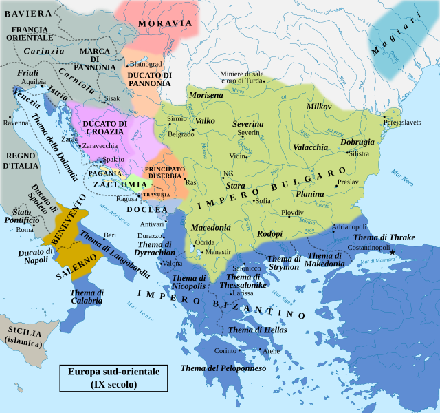
Italiano: Mappa geopolitica dell'Europa sud-orientale intorno all'anno 850 d.C. |
| Fecha | |
| Fuente | File:Balkans850-es.svg |
| Autor | Rowanwindwhistler (original work); Mess (derivative work with Italian translation) |
Licencia
[editar]
Este archivo está disponible bajo la licencia Creative Commons Attribution-Share Alike 4.0 International.
- Eres libre:
- de compartir – de copiar, distribuir y transmitir el trabajo
- de remezclar – de adaptar el trabajo
- Bajo las siguientes condiciones:
- atribución – Debes otorgar el crédito correspondiente, proporcionar un enlace a la licencia e indicar si realizaste algún cambio. Puedes hacerlo de cualquier manera razonable pero no de manera que sugiera que el licenciante te respalda a ti o al uso que hagas del trabajo.
- compartir igual – En caso de mezclar, transformar o modificar este trabajo, deberás distribuir el trabajo resultante bajo la misma licencia o una compatible como el original.
Historial del archivo
Haz clic sobre una fecha y hora para ver el archivo tal como apareció en ese momento.
| Fecha y hora | Miniatura | Dimensiones | Usuario | Comentario | |
|---|---|---|---|---|---|
| actual | 17:13 23 jun 2022 | | 1521 × 1424 (1,67 MB) | Mess (discusión | contribs.) | text fix |
| 22:09 22 jun 2022 |  | 1521 × 1424 (1,67 MB) | Mess (discusión | contribs.) | text fix | |
| 22:07 22 jun 2022 |  | 1521 × 1424 (1,67 MB) | Mess (discusión | contribs.) | text fix | |
| 21:56 22 jun 2022 |  | 1521 × 1424 (1,67 MB) | Mess (discusión | contribs.) | Uploaded a work by Rowanwindwhistler (original work); Mess (derivative work with Italian translation) from File:Balkans850-es.svg with UploadWizard |
No puedes sobrescribir este archivo.
Usos del archivo
La siguiente página usa este archivo:
Uso global del archivo
Las wikis siguientes utilizan este archivo:
- Uso en de.wikipedia.org
- Uso en it.wikipedia.org
- Primo Impero bulgaro
- Regno di Croazia (Medioevo)
- Guerra bulgaro-bizantina dell'894-896
- Battaglia del Bug meridionale
- Khanato bulgaro del Danubio
- Protocronismo
- Assedio di Ragusa (866-868)
- Honfoglalás
- Progetto:Laboratorio grafico/Immagini da migliorare/Archivio risolte/238
- Storia dell'Ungheria pre-magiara
- Principato di Serbia (medievale)
- Prosigoj di Serbia
- Mutimiro di Serbia
- Clonimiro
- Vlastimirović
- Guerra bulgaro-serba (839-842)
- Guerra bulgaro-serba (853)
- Battesimo dei quattordici duchi boemi
Metadatos
Categorías:
- Maps of 9th-century Europe
- Maps of 9th-century Greece
- Maps of Great Moravia
- Maps of Slavic states in Pannonia
- Maps of medieval Bosnian and neighboring states
- Maps of the Byzantine empire in the 9th century
- Maps of the history of Bosnia and Herzegovina in the Early Middle Ages
- Maps of 9th-century Bulgaria
- Maps of the history of Croatia in the Middle Ages
- Maps of the history of Romania in the Middle Ages
- Maps of the history of Serbia in the Early Middle Ages
- Maps of the history of the medieval Balkans
- Maps of the prehistory of Hungary
- Romania in the 9th century
- Italian-language maps showing history of Europe