File:Ball's Pyramid2.jpg
Ir a la navegación
Ir a la búsqueda
No disponible a mayor resolución.
Ball's_Pyramid2.jpg (317 × 356 píxeles; tamaño de archivo: 22 kB; tipo MIME: image/jpeg)
Leyendas
Leyendas
Añade una explicación corta acerca de lo que representa este archivo
Resumen
[editar]
| Descripción |
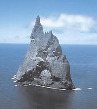
English: Aerial view of Ball’s Pyramid, Lord Howe Island Group, NSW, Australia |
| Fecha | not specified |
| Fuente | http://pollux.nss.nima.mil/NAV_PUBS/SD/Pub127/, page 105 (jpg extracted from pdf document) |
| Autor | National Imagery and Mapping Agency (NIMA), now National Geospatial-Intelligence Agency |
Licencia
[editar]
This image is a work of the United States National Geospatial-Intelligence Agency or one of its predecessor agencies. As a work of the U.S. federal government, the image is in the public domain.
|
 |
Registro original de carga
[editar]
(All user names refer to en.wikipedia)
- 2006-02-25 21:36 Ratzer 317×356 (22022 bytes) (http://pollux.nss.nima.mil/NAV_PUBS/SD/Pub127/, page 105 (jpg extracted from pdf document))
Historial del archivo
Haz clic sobre una fecha y hora para ver el archivo tal como apareció en ese momento.
| Fecha y hora | Miniatura | Dimensiones | Usuario | Comentario | |
|---|---|---|---|---|---|
| actual | 19:08 21 ago 2006 | | 317 × 356 (22 kB) | Liftarn (discusión | contribs.) | {{Information| |Description=Ball's Pyramid |Source=http://pollux.nss.nima.mil/NAV_PUBS/SD/Pub127/, page 105 (jpg extracted from pdf document) |Date= |Author=User Ratzer on [http://en.wikipedia.org en.wikipedia] |Permission={{PD-USGov}} |
No puedes sobrescribir este archivo.
Usos del archivo
La siguiente página usa este archivo:
Uso global del archivo
Las wikis siguientes utilizan este archivo:
- Uso en ar.wikipedia.org
- Uso en az.wikipedia.org
- Uso en be.wikipedia.org
- Uso en bg.wikipedia.org
- Uso en cs.wikipedia.org
- Uso en de.wikipedia.org
- Uso en el.wikipedia.org
- Uso en en.wikipedia.org
- Uso en es.wikipedia.org
- Uso en frr.wikipedia.org
- Uso en fy.wikipedia.org
- Uso en he.wikipedia.org
- Uso en hr.wikipedia.org
- Uso en hu.wikipedia.org
- Uso en hyw.wikipedia.org
- Uso en id.wikipedia.org
- Uso en it.wikipedia.org
- Uso en ka.wikipedia.org
- Uso en ksh.wikipedia.org
- Uso en ky.wikipedia.org
- Uso en lt.wikipedia.org
- Uso en ms.wikipedia.org
- Uso en nn.wikipedia.org
- Uso en no.wikipedia.org
- Uso en pl.wikipedia.org
- Uso en pt.wikipedia.org
- Uso en ru.wikipedia.org
- Uso en sh.wikipedia.org
Ver más uso global de este archivo.