File:Banduri and Lisle. Imperii Orientalis et Circumjacentium Regionum.C (Chazaria, Alania, Zichia, Uzia, Abasgia).jpg
Naviqasiyaya keç
Axtarışa keç
Sınaq göstərişi ölçüsü: 800 × 470 piksel. Digər ölçülər: 320 × 188 piksel | 640 × 376 piksel | 1.024 × 601 piksel | 1.280 × 752 piksel | 2.748 × 1.614 piksel.
Faylın orijinalı (2.748 × 1.614 piksel, fayl həcmi: 867 KB, MIME növü: image/jpeg)
Captions
Captions
Add a one-line explanation of what this file represents
|
|

Xülasə[redaktə]
| İzah |
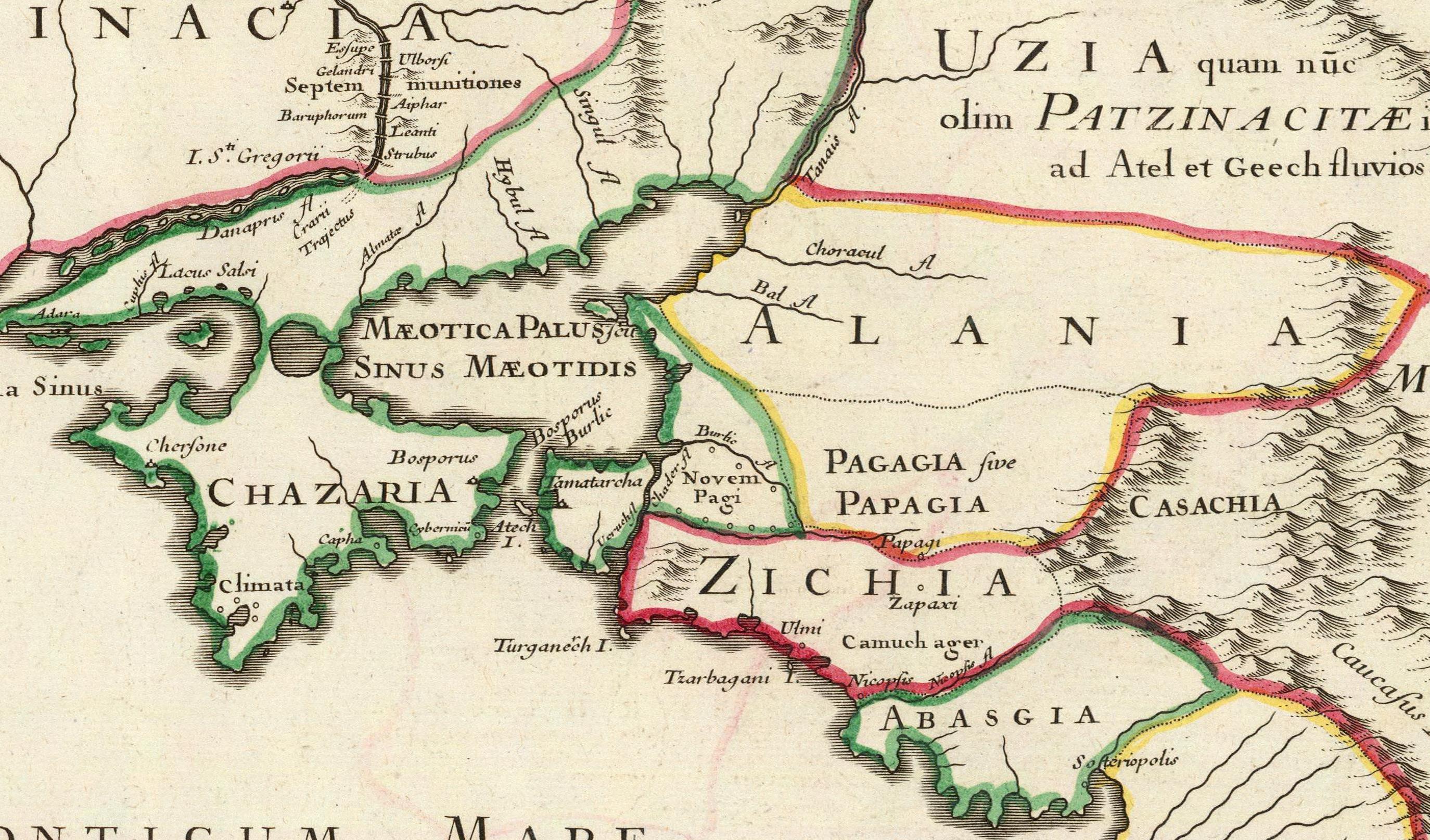
Latina: Imperii Orientalis et Circumjacentium Regionum, sub Constantino Porphyrogenito et ejus praedecessoribus descriptio. Auctore Guillelmo Del'Isle e Regia Scientiarum Academia, ad novam editionem Libri Constantini Porphyrogeniti de Administrando Imperio quae prodit studio Anselmi Bandurii, Monachi Benedictini Ragusini Melitensis cum ejus dem note et animadversionibus. (Paris : Guillelmo Del'Isle, 1715?). |
|||||||||||||||||||||||
| Tarix | circa 1715 | |||||||||||||||||||||||
| Mənbə |
|
|||||||||||||||||||||||
| Müəllif |
Anselmo Maria Banduri (1675-1743)
|
|||||||||||||||||||||||


.jpg&action=edit§ion=1)
Lisenziya[redaktə]
.jpg&action=edit§ion=2)
|
Bu şəkil, təsviri incəsənət əsərinin orijinal ikiölçülü dəqiq fotoqrafiya reproduksiyasıdır. Təsviri incəsənətin bu əsəri öz-özlüyündə aşağıdakı səbəblərdən ictimai varidat sayılır:
"Vikimedia Fondu" tutduğu rəsmi mövqe ondan ibarətdir ki, "ictimai varidat olan təsviri incəsənət əsərlərinin ikiölçülü dəqiq reproduksiyaları da ictimai varidat sayılır". Ətraflı məlumat almaq üçün Commons:When to use the PD-Art tag məqaləsinə baxın.
Beləliklə bu fotoqrafiya reproduksiyası ictimai varidat hesab edilir. Xahiş edirik nəzərə alın ki, yerli qanunvericilikdən asılı olaraq bu məzmunun təkrar istifadəsi qadağandır və ya sizin yurisdiksiyanızda bu məzmun məhdudlaşdırılmış ola bilər. Commons:Reuse of PD-Art photographs məqaləsinə baxın. | ||||
Faylın tarixçəsi
Faylın əvvəlki versiyasını görmək üçün gün/tarix bölməsindəki tarixlərə klikləyin.
| Tarix/Vaxt | Kiçik şəkil | Ölçülər | İstifadəçi | Şərh | |
|---|---|---|---|---|---|
| indiki | 20:33, 29 yanvar 2011 | | 2.748 × 1.614 (867 KB) | Geagea (müzakirə | töhfələr) |
Siz bu faylı yenidən yükləyə bilməzsiniz.
Fayl keçidləri
Aşağıdakı 2 səhifə bu faylı istifadə edir:
Faylın qlobal istifadəsi
Bu fayl aşağıdakı vikilərdə istifadə olunur:
- az.wikipedia.org layihəsində istifadəsi
- ba.wikipedia.org layihəsində istifadəsi
- de.wikipedia.org layihəsində istifadəsi
- en.wikipedia.org layihəsində istifadəsi
- fr.wikipedia.org layihəsində istifadəsi
- ru.wikipedia.org layihəsində istifadəsi
- tr.wikipedia.org layihəsində istifadəsi
Metaməlumatlar
.jpg&oldid=830639833)
Kateqoriyalar:
- Imperii Orientalis et Circumjacentium Regionum (early 18th century map) by Guillaume Delisle
- Details of old maps
- 18th-century maps of Circassia
- 1715 maps of the Tsardom of Russia
- Old maps of Samegrelo
- 1710s maps of Abkhazia
- Maps of the Khazars
- Maps of Alania
- Old maps of the Sea of Azov
- 18th-century maps of Crimea