File:Banqiaomap.png
跳至導覽
跳至搜尋

預覽大小:574 × 599 像素。 其他解析度:230 × 240 像素 | 460 × 480 像素 | 736 × 768 像素 | 1,078 × 1,125 像素。
原始檔案 (1,078 × 1,125 像素,檔案大小:82 KB,MIME 類型:image/png)
說明
說明
添加單行說明來描述出檔案所代表的內容
| 描述 | Banqiao Dam | ||||||||
| 日期 | |||||||||
| 來源 | en.wikipedia | ||||||||
| 作者 | Rolfmueller | ||||||||
| 授權許可 (重用此檔案) |
Rolfmueller 位于英语维基百科,此作品的版權所有人,決定用以下授權條款發佈本作品:
|

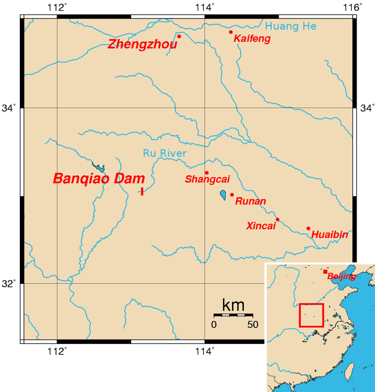
Map of the location of Banqiao Dam. The location of the dam is approximate and assumes that it is close to the village of the same name. The coordinates (longitude, latitude) of the other cities shown on the map are:
- Zhengzhou 113.6500, 34.8000
- Kaifeng 114.3500, 34.8500
- Shangcai 114.0250, 33.2666
- Runan 114.3666, 33.0166
- Xincai 114.9833, 32.7333
- Huaibin 115.4000, 32.6333
This map was created using the Generic Mapping Tools (GMT).
- The location of the dam is accurate — it's right next to the village of the same name. :) -- ran (talk) 06:14, Apr 6, 2005 (UTC)
External Link
[編輯]
檔案歷史
點選日期/時間以檢視該時間的檔案版本。
| 日期/時間 | 縮圖 | 尺寸 | 使用者 | 備註 | |
|---|---|---|---|---|---|
| 目前 | 2008年4月25日 (五) 08:59 | | 1,078 × 1,125(82 KB) | Hellisp(留言 | 貢獻) | {{Information |Description=Banqiao Dam |Source=en.wikipedia |Date=25-4-2008 |Author= Rolfmueller |Permission={{GFDL-user-w|en|Wikipedia|Rolfmueller}} |other_versions= }} Map of the location of Banqiao Dam. The location of the dam is approximate and a |
無法覆蓋此檔案。
檔案用途
下列2個頁面有用到此檔案:
全域檔案使用狀況
以下其他 wiki 使用了這個檔案:
- arz.wikipedia.org 的使用狀況
- ceb.wikipedia.org 的使用狀況
- cs.wikipedia.org 的使用狀況
- en.wikipedia.org 的使用狀況
- es.wikipedia.org 的使用狀況
- fi.wikipedia.org 的使用狀況
- fr.wikipedia.org 的使用狀況
- it.wikipedia.org 的使用狀況
- ja.wikipedia.org 的使用狀況
- ko.wikipedia.org 的使用狀況
- nl.wikipedia.org 的使用狀況
- no.wikipedia.org 的使用狀況
- pt.wikipedia.org 的使用狀況
- ro.wikipedia.org 的使用狀況
- uk.wikipedia.org 的使用狀況
- www.wikidata.org 的使用狀況
- zh.wikipedia.org 的使用狀況