File:Barnes Ice Cap, Baffin Island, Canada.jpg
Zur Navigation springen
Zur Suche springen

Größe dieser Vorschau: 336 × 599 Pixel. Weitere Auflösungen: 134 × 240 Pixel | 269 × 480 Pixel | 430 × 768 Pixel | 574 × 1.024 Pixel | 2.243 × 4.000 Pixel.
Originaldatei (2.243 × 4.000 Pixel, Dateigröße: 4,55 MB, MIME-Typ: image/jpeg)
Bildtexte
Kurzbeschreibungen
Ergänze eine einzeilige Erklärung, was diese Datei darstellt.
Beschreibung[Bearbeiten]
| Beschreibung |
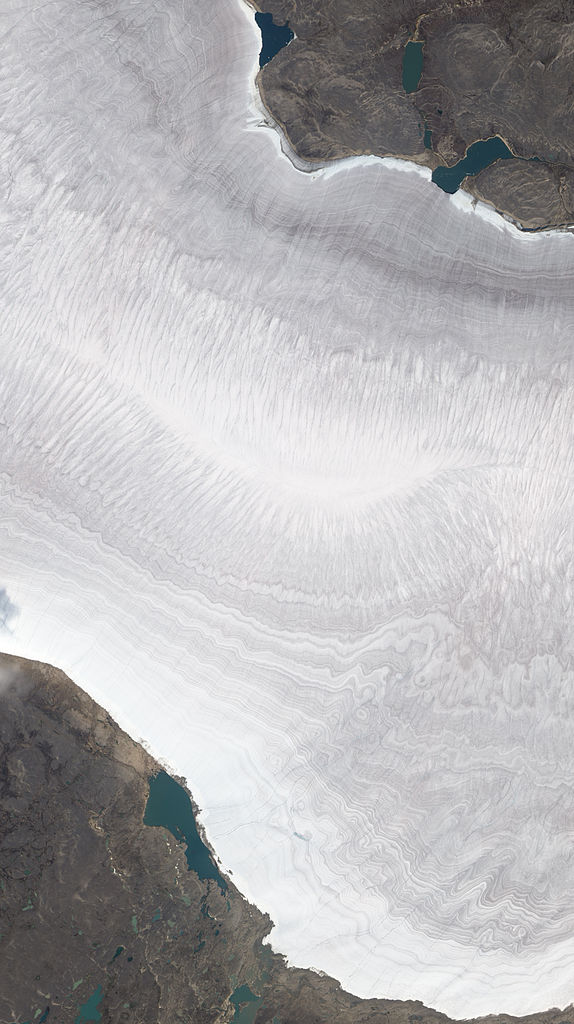
English: Natural-colour image of the Barnes Ice Cap, a bowling-pin-shaped glacier on Canada’s Baffin Island. The image shows a portion of the Barnes Ice Cap near its south-eastern end. Gee Lake sits immediately off the glacier. Resembling growth lines on a clamshell, striations run roughly east-west on the glacier surface. Rather than appearing pristine white, the ice and snow is banded with dust layers spanning time periods that dwarf a human life. By studying ice cores containing such dust layers, climatologists can find clues to ancient climates.
Ted Scambos of the National Snow and Ice Data Center observes that although the ice cap is essentially flat, it appears to undulate, thanks to ridges cut by melt streams running off the glacier. In this summertime shot, the glacier is mostly snow-free except for a band of snow along the edge near Gee Lake. As winter returns, snow will once again cover the glacier, the surrounding land, and the lake. |
| Datum | |
| Quelle | NASA Earth Observatory |
| Urheber | Jesse Allen and Robert Simmon |
| Andere Versionen |
|

Image captured by The Advanced Land Imager (ALI) on NASA’s Earth Observing-1 (EO-1) satellite. EO-1 ALI data provided courtesy of the NASA EO-1 team.
Lizenz[Bearbeiten]
| Diese Datei ist gemeinfrei (public domain), da sie von der NASA erstellt worden ist. Die NASA-Urheberrechtsrichtlinie besagt, dass „NASA-Material nicht durch Urheberrecht geschützt ist, wenn es nicht anders angegeben ist“. (NASA-Urheberrechtsrichtlinie-Seite oder JPL Image Use Policy). | ||
 |
Warnung:
|
| Bildnotizen | Diese Datei ist annotiert: Betrachte diese auf Commons. |
Dateiversionen
Klicke auf einen Zeitpunkt, um diese Version zu laden.
| Version vom | Vorschaubild | Maße | Benutzer | Kommentar | |
|---|---|---|---|---|---|
| aktuell | 10:30, 11. Okt. 2010 | | 2.243 × 4.000 (4,55 MB) | Originalwana (Diskussion | Beiträge) | {{Information |Description={{en|1=Natural-colour image of the Barnes Ice Cap, a bowling-pin-shaped glacier on Canada’s Baffin Island. The image shows a portion of the Barnes Ice Cap near its south-eastern end. Gee Lake sits immediately off the glaci |
Du kannst diese Datei nicht überschreiben.
Dateiverwendung
Die folgende Seite verwendet diese Datei:
Globale Dateiverwendung
Die nachfolgenden anderen Wikis verwenden diese Datei:
- Verwendung auf de.wikipedia.org
- Verwendung auf en.wikipedia.org
- Verwendung auf fi.wikipedia.org
- Verwendung auf fr.wikipedia.org