File:Battle of Winterthur details.png
跳至導覽
跳至搜尋
預覽大小:800 × 523 像素。 其他解析度:320 × 209 像素 | 640 × 418 像素 | 1,024 × 670 像素 | 1,508 × 986 像素。
原始檔案 (1,508 × 986 像素,檔案大小:1.39 MB,MIME 類型:image/png)
說明
說明
添加單行說明來描述出檔案所代表的內容

|
本圖片是以PNG、GIF或JPEG格式上傳。然而,其中包含的資料或訊息,應該重新建立成可縮放向量圖形(SVG)檔案,以更有效率或更準確的方式儲存。如有可能,請上傳本圖片的SVG格式版本。在上傳之後,請修改維基各姊妹計畫中所有使用舊版圖片的條目(列在圖像連結章節中),替換為新版圖片,並在舊圖片的描述頁中加入{{Vector version available|新圖片名稱.svg}}模板,同時移除本模板。
|
摘要
[編輯]
| 描述 |
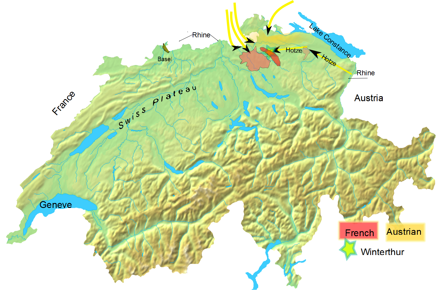
English: Overall troop positioning in late May 1799 for Battle of Winterthur. |
| 日期 | (UTC) |
| 來源 |
我個人以下列物件為基礎來創作: Switzerland topographic.png |
| 作者 |
|
| 這是一張修飾過的圖片,即本圖片是用軟體修改過後的版本,修改的方式或內容有:added Battle of Winterthur to it。原版圖片來源:Switzerland topographic.png。修改者:Auntieruth55。
|
我,本作品的著作權持有者,決定用以下授權條款發佈本作品:
| 我,此作品的版權所有人,釋出此作品至公共領域。此授權條款在全世界均適用。 這可能在某些國家不合法,如果是的話: 我授予任何人有權利使用此作品於任何用途,除受法律約束外,不受任何限制。 |
原始上傳日誌
[編輯]
This image is a derivative work of the following images:
- File:Switzerland_topographic.png licensed with PD-self
- 2007-04-16T19:05:28Z Numerus Klausus 1508x958 (1819472 Bytes) {{Information |Description=Blanc topographic Map of Switzerland / Relief-Karte der Schweiz (blanko) |Source= Map created from [http://www2.demis.nl/mapserver/mapper.asp DEMIS Mapserver], which are public domain. |Date= 2007 |
Uploaded with derivativeFX
檔案歷史
點選日期/時間以檢視該時間的檔案版本。
| 日期/時間 | 縮圖 | 尺寸 | 用戶 | 備註 | |
|---|---|---|---|---|---|
| 目前 | 2010年2月11日 (四) 00:01 | | 1,508 × 986(1.39 MB) | Auntieruth55(對話 | 貢獻) | {{Information |Description=Overall troop positioning in late May 1799 for Battle of Winterthur |Source=*File:Switzerland_topographic.png |Date=2010-02-11 00:00 (UTC) |Author=*File:Switzerland_topographic.png: User:Numerus Klausus / [[:de:B |
無法覆蓋此檔案。
檔案用途
沒有使用此檔案的頁面。
全域檔案使用狀況
以下其他 wiki 使用了這個檔案:
- en.wikipedia.org 的使用狀況
- es.wikipedia.org 的使用狀況
- et.wikipedia.org 的使用狀況
- fa.wikipedia.org 的使用狀況
- he.wikipedia.org 的使用狀況
- id.wikipedia.org 的使用狀況
- te.wikipedia.org 的使用狀況
- uz.wikipedia.org 的使用狀況
- zh.wikipedia.org 的使用狀況