File:Bay-of-Piran maritime-boundary-dispute.jpg
Przejdź do nawigacji
Przejdź do wyszukiwania
Grafika w wyższej rozdzielczości nie jest dostępna.
Bay-of-Piran_maritime-boundary-dispute.jpg (709 × 600 pikseli, rozmiar pliku: 160 KB, typ MIME: image/jpeg)
Podpisy
Podpisy
Dodaj jednolinijkowe objaśnienie tego, co ten plik pokazuje
Opis
[edytuj]
|
Ta ilustracja ma także wersję wektorową („SVG”).
Zaleca się wykorzystywanie w galeriach dostępnej wersji wektorowej zamiast obecnej. File:Bay-of-Piran maritime-boundary-dispute.jpg → File:Bay-of-Piran maritime-boundary-dispute.svg
Więcej o grafice wektorowej przeczytasz w artykule Przenoszenie grafik Commons do formatu SVG. Dostępna jest także informacja o obsłudze grafik SVG przez MediaWiki. |
 |
| Opis |
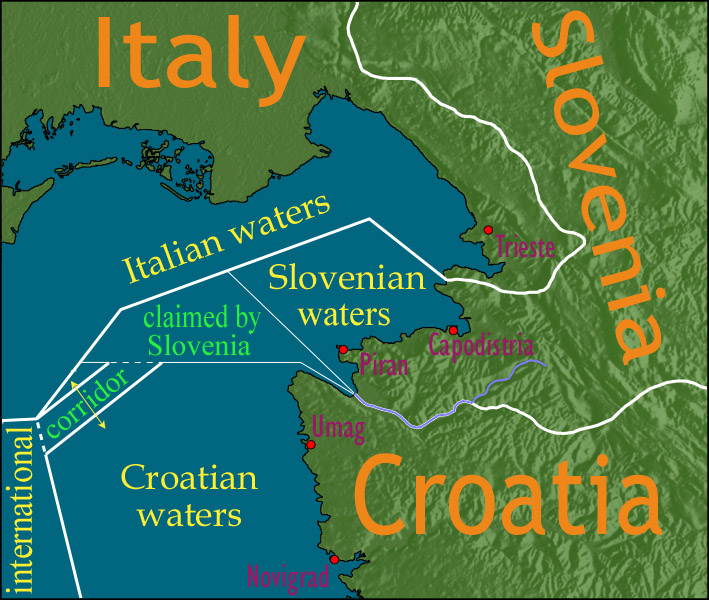
English: Map showing a diplomatic dispute resulting from Slovenia's desire to obtain a direct corridor from its own territorial waters to international waters, to avoid the necessity of Slovenian ships having to sail through the territorial waters of any other country to get to the high seas. Slovenia's only seacoast is in the Bay of Piran / Gulf of Trieste (as shown in this map), and its only commercial seaport is Capodistria / Koper (the eastern of the two red dots in Slovenia on this map), while Italy and Croatia both have long seacoasts outside the area shown in this map.
Slovenia's claim to the area labelled with green text, and the existence of a corridor to international waters, would have been allowed by Croatia under the Drnovšek-Račan agreement, but this was never ratified by either countries' parliaments. This is an English version of image de:Bild:Grenzstreit-Bucht-von-Piran.jpg, created using image Image:BorderDispute_BayOfPiran_blank.png. Raw Adobe Photoshop PSD files (with all text on different type layers) are available on request. |
| Data | |
| Źródło | File:BorderDispute_BayOfPiran_blank.png |
| Autor |
|
| Licencja (Ponowne użycie tego pliku) |
The underlying source Image:BorderDispute_BayOfPiran_blank.png is declared to be GFDL, while I declare my changes to it to be PD. |
| Inne wersje | Prace pochodne od tego pliku: Bay-of-Piran maritime-boundary-dispute.svg |

Licencja
[edytuj]

|
Udziela się zgody na kopiowanie, rozpowszechnianie oraz modyfikowanie tego dokumentu zgodnie z warunkami GNU Licencji Wolnej Dokumentacji, w wersji 1.2 lub nowszej opublikowanej przez Free Software Foundation; bez niezmiennych sekcji, bez treści umieszczonych na frontowej lub tylnej stronie okładki. Kopia licencji załączona jest w sekcji zatytułowanej GNU Licencja Wolnej Dokumentacji. |
| Ten plik udostępniony jest na licencji Creative Commons Uznanie autorstwa – Na tych samych warunkach 3.0. | ||
| ||
| Ten szablon został dodany jako element zmiany licencjonowania. |
Historia pliku
Kliknij na odpowiedniej dacie/czasie, aby zobaczyć wersję pliku z tamtego okresu.
| Data/czas | Miniatura | Wymiary | Użytkownik | Opis | |
|---|---|---|---|---|---|
| aktualny | 14:17, 8 sty 2007 | | 709 × 600 (160 KB) | AnonMoos (dyskusja | edycje) | adding city names |
| 18:13, 24 gru 2006 |  | 709 × 600 (156 KB) | AnonMoos (dyskusja | edycje) | deepening colors slightly | |
| 14:00, 14 gru 2006 |  | 709 × 600 (156 KB) | AnonMoos (dyskusja | edycje) | Map showing diplomatic dispute over Slovenia's desire to obtain a direct corridor from its own territorial waters to international waters, to avoid Slovenian ships having to sail through the territorial waters of any other country to get to the high seas. |
Nie możesz nadpisać tego pliku.
Lokalne wykorzystanie pliku
Następujące strony korzystają z tego pliku:
- Atlas of Croatia
- Atlas of Italy
- Atlas of Slovenia
- User:AnonMoos/Gallery (non-self)
- File:Bay-of-Piran maritime-boundary-dispute-ar.png
- File:Bay-of-Piran maritime-boundary-dispute-br.svg
- File:Bay-of-Piran maritime-boundary-dispute-eo.svg
- File:Bay-of-Piran maritime-boundary-dispute-fr.svg
- File:Bay-of-Piran maritime-boundary-dispute-hr.svg
- File:Bay-of-Piran maritime-boundary-dispute-hu.svg
- File:Bay-of-Piran maritime-boundary-dispute-it.SVG
- File:Bay-of-Piran maritime-boundary-dispute-mk.SVG
- File:Bay-of-Piran maritime-boundary-dispute-ru.svg
- File:Bay-of-Piran maritime-boundary-dispute-sr.svg
- File:Bay-of-Piran maritime-boundary-dispute.svg
- Template:Other versions/Bay-of-Piran maritime-boundary-dispute
Globalne wykorzystanie pliku
Ten plik jest wykorzystywany także w innych projektach wiki:
- Wykorzystanie na de.wikipedia.org
- Wykorzystanie na en.wikipedia.org
- Wykorzystanie na en.wikinews.org
- Wykorzystanie na es.wikipedia.org
- Wykorzystanie na fy.wikipedia.org
- Wykorzystanie na it.wikipedia.org
- Wykorzystanie na ja.wikipedia.org
- Wykorzystanie na ko.wikipedia.org
- Wykorzystanie na pl.wikipedia.org
- Wykorzystanie na sl.wikipedia.org
- Wykorzystanie na zh.wikipedia.org