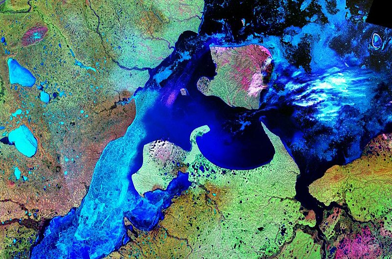
File:Bay of Nordvik - Landsat 7 - Pseudo.jpg
Commons – repozytorium wolnych multimediów
Przejdź do nawigacji
Przejdź do wyszukiwania

Rozmiar podglądu – 800 × 529 pikseli. Inne rozdzielczości: 320 × 212 pikseli | 640 × 423 pikseli | 1024 × 677 pikseli.
Rozmiar pierwotny (1024 × 677 pikseli, rozmiar pliku: 198 KB, typ MIME: image/jpeg)
Informacje o pliku
Dane strukturalne
Podpisy
Podpisy
Dodaj jednolinijkowe objaśnienie tego, co ten plik pokazuje
Opis
[edytuj]| OpisBay of Nordvik - Landsat 7 - Pseudo.jpg |
English: The Siberian Bay of Nordvik (center) between the rivershed areas of the Khatanga (left: Khatanga Gulf) and Anabar (right: Anabar Gulf). To the north is located the island Bolshoy Begichev. On the left the eastern part of the Taymyr Peninsula and to the north the Laptev Sea. Landsat 7 Pseudo color image. |
| Data | 20 sierpnia 2006 (data przesłania) |
| Źródło | Satellite imagery taken from NASA World Wind software (by screenshot) |
| Autor | NASA |
Licencja
[edytuj]| Public domainPublic domainfalsefalse |
| This image is in the public domain because it is a screenshot from NASA’s globe software World Wind using a public domain layer, such as Blue Marble, MODIS, Landsat, SRTM, USGS or GLOBE.
العربيَّة | English | فارسی | français | עברית | македонски | മലയാളം | Nederlands | русский | 中文(中国大陆) | +/− |
Historia pliku
Kliknij na odpowiedniej dacie/czasie, aby zobaczyć wersję pliku z tamtego okresu.
| Data/czas | Miniatura | Wymiary | Użytkownik | Opis | |
|---|---|---|---|---|---|
| aktualny | 11:33, 20 sie 2006 |  | 1024 × 677 (198 KB) | Hardscarf (dyskusja | edycje) | The Siberian Bay of Nordvik (center) between the rivershed areas of the Khatanga (left: Khatanga Gulf) and Anabar (right: Anabar Gulf). To the north is located the island Bolshoy Begichev. On the left the eastern part of the Taymyr Peninsula and to the no |
Nie możesz nadpisać tego pliku.
Lokalne wykorzystanie pliku
Żadna strona nie korzysta z tego pliku.
Globalne wykorzystanie pliku
Ten plik jest wykorzystywany także w innych projektach wiki:
- Wykorzystanie na arz.wikipedia.org
- Wykorzystanie na be.wikipedia.org
- Wykorzystanie na bg.wikipedia.org
- Wykorzystanie na ca.wikipedia.org
- Wykorzystanie na ceb.wikipedia.org
- Wykorzystanie na de.wikipedia.org
- Wykorzystanie na en.wikipedia.org
- Wykorzystanie na es.wikipedia.org
- Wykorzystanie na gl.wikipedia.org
- Wykorzystanie na it.wikipedia.org
- Wykorzystanie na nl.wikipedia.org
- Wykorzystanie na nn.wikipedia.org
- Wykorzystanie na pl.wikipedia.org
- Wykorzystanie na ru.wikipedia.org
- Wykorzystanie na uk.wikipedia.org
- Wykorzystanie na www.wikidata.org
Metadane
Niniejszy plik zawiera dodatkowe informacje, prawdopodobnie dodane przez aparat cyfrowy lub skaner użyte do wygenerowania tego pliku.
Jeśli plik był modyfikowany, dane mogą być częściowo niezgodne z parametrami zmodyfikowanego pliku.
| _error | 0 |
|---|
