File:Belgian colonial empire.png
跳转到导航
跳转到搜索

本预览的尺寸:800 × 351像素。 其他分辨率:320 × 140像素 | 640 × 281像素 | 1,425 × 625像素。
原始文件 (1,425 × 625像素,文件大小:38 KB,MIME类型:image/png)
说明
说明
添加一行文字以描述该文件所表现的内容
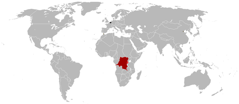
Belgian Colonial Empire

|
File:Belgian colonial empire.svg是此文件的矢量版本。 如果此文件质量不低于原点阵图,就应该将这个PNG格式文件替换为此文件。
File:Belgian colonial empire.png → File:Belgian colonial empire.svg
更多信息请参阅Help:SVG/zh。 |
 |
摘要
[编辑]
- Black = Belgium
- Dark red = Belgian Congo (1908-1960)
- Light red = Ruanda-Urundi (1916-1962)
- Yellow squares = Tientsin, China (concession zone) and Tanger, Morocco (international zone)
许可协议
[编辑]
我,本作品著作权人,特此采用以下许可协议发表本作品:

|
已授权您依据自由软件基金会发行的无固定段落及封面封底文字(Invariant Sections, Front-Cover Texts, and Back-Cover Texts)的GNU自由文件许可协议1.2版或任意后续版本的条款,复制、传播和/或修改本文件。该协议的副本请见“GNU Free Documentation License”。 |
| 本文件采用知识共享署名-相同方式共享 3.0 未本地化版本许可协议授权。 | ||
| ||
| 本许可协议标签作为GFDL许可协议更新的组成部分被添加至本文件。 |
文件历史
点击某个日期/时间查看对应时刻的文件。
| 日期/时间 | 缩略图 | 大小 | 用户 | 备注 | |
|---|---|---|---|---|---|
| 当前 | 2023年7月16日 (日) 01:54 | | 1,425 × 625(38 KB) | Randomastwritter(留言 | 贡献) | added jubaland |
| 2017年3月8日 (三) 01:34 |  | 1,425 × 625(48 KB) | Grachifan(留言 | 贡献) | adding missing belgiujm in black | |
| 2016年8月20日 (六) 14:07 |  | 1,425 × 625(38 KB) | The-(留言 | 贡献) | Better map | |
| 2016年8月17日 (三) 17:12 |  | 1,357 × 628(2.44 MB) | RVBatman32(留言 | 贡献) | Reverted to version as of 17:10, 17 August 2016 (UTC) | |
| 2016年8月17日 (三) 17:11 |  | 1,357 × 628(2.44 MB) | RVBatman32(留言 | 贡献) | Reverted to version as of 18:51, 4 June 2016 (UTC) Don't know why Iran was missing,reverted | |
| 2016年8月17日 (三) 17:10 |  | 1,357 × 628(2.44 MB) | RVBatman32(留言 | 贡献) | Reverted to version as of 18:51, 4 June 2016 (UTC) | |
| 2016年7月31日 (日) 12:07 |  | 1,425 × 625(38 KB) | The-(留言 | 贡献) | Better map | |
| 2016年6月4日 (六) 18:51 |  | 1,357 × 628(2.44 MB) | Roxanna(留言 | 贡献) | Reverted to version as of 13:19, 11 January 2013 (UTC) Belgium! Not Netherlands! | |
| 2016年5月6日 (五) 12:03 |  | 1,425 × 625(38 KB) | The-(留言 | 贡献) | Better map | |
| 2013年1月11日 (五) 13:19 |  | 1,357 × 628(2.44 MB) | Roxanna(留言 | 贡献) | including International Zone of Tanger (same marked as Tientin) |
您不可以覆盖此文件。
文件用途
没有页面使用本文件。
全域文件用途
以下其他wiki使用此文件:
- de.wikipedia.org上的用途
- es.wikipedia.org上的用途
- hy.wikipedia.org上的用途
- sk.wikipedia.org上的用途
- zh.wikipedia.org上的用途