File:Bengal fan-labeled.png
跳转到导航
跳转到搜索

本预览的尺寸:800 × 441像素。 其他分辨率:320 × 176像素 | 640 × 353像素 | 1,195 × 659像素。
原始文件 (1,195 × 659像素,文件大小:825 KB,MIME类型:image/png)
说明
说明
添加一行文字以描述该文件所表现的内容
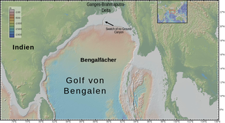
bathymetry of Bay of Bengal, with the submarine Bengal fan and submarine "Swatch of No Ground" Canyon
摘要
[编辑]
| 描述 |
English: bathymetry of en:Bay of Bengal, with the submarine Bengal fan and submarine "Swatch of No Ground" Canyon
Deutsch: Topografie des Ozeanbodes im de:Golf von Bengalen, der vom submarinen de:Bengalfächer gebildet wird. Im Norden ist der submarine Canyon "Swatch of no Ground" erkennbar. |
| 日期 | |
| 来源 | http://www.geomapapp.org/index.htm |
| 作者 | igure made with GeoMapApp (www.geomapapp.org) / CC BY, CC BY (Ryan et al., 2009). labelled by User:DeWikiMan |
Sources:
- Ryan, W. B. F., S.M. Carbotte, J. Coplan, S. O'Hara, A. Melkonian, R. Arko, R.A. Weissel, V. Ferrini, A. Goodwillie, F. Nitsche, J. Bonczkowski, and R. Zemsky (2009), Global Multi-Resolution Topography (GMRT) synthesis data set, Geochem. Geophys. Geosyst., 10, Q03014, doi:10.1029/2008GC002332.
- Data doi: 10.1594/IEDA.0001000
- GeoMappApp (www.geomapapp.org)
许可协议
[编辑]
文件历史
点击某个日期/时间查看对应时刻的文件。
| 日期/时间 | 缩略图 | 大小 | 用户 | 备注 | |
|---|---|---|---|---|---|
| 当前 | 2020年3月29日 (日) 21:18 | | 1,195 × 659(825 KB) | DeWikiMan(留言 | 贡献) | {{Information |description ={{en|1=bathymetry of en:Bay of Bengal, with the submarine Bengal fan and submarine "Swatch of No Ground" Canyon}} {{de|1=Topografie des Ozeanbodes im de:Golf von Bengalen, der vom submarinen de:Bengalfächer gebildet wird. Im Norden ist der submarine Canyon "Swatch of no Ground" erkennbar.}} |date =2020-03-29 |source =http://www.geomapapp.org/index.htm |author =igure made with GeoMapApp (www.geomapapp.org) / CC BY, CC BY (Rya... |
您不可以覆盖此文件。
文件用途
没有页面使用本文件。
全域文件用途
以下其他wiki使用此文件:
- de.wikipedia.org上的用途
- en.wikipedia.org上的用途
- ja.wikipedia.org上的用途
- uk.wikipedia.org上的用途
- www.wikidata.org上的用途
- zh.wikipedia.org上的用途