File:Bengal fan-labeled.png
跳至導覽
跳至搜尋

預覽大小:800 × 441 像素。 其他解析度:320 × 176 像素 | 640 × 353 像素 | 1,195 × 659 像素。
原始檔案 (1,195 × 659 像素,檔案大小:825 KB,MIME 類型:image/png)
說明
說明
添加單行說明來描述出檔案所代表的內容
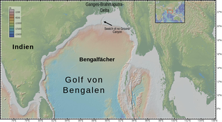
bathymetry of Bay of Bengal, with the submarine Bengal fan and submarine "Swatch of No Ground" Canyon
摘要
[編輯]
| 描述 |
English: bathymetry of en:Bay of Bengal, with the submarine Bengal fan and submarine "Swatch of No Ground" Canyon
Deutsch: Topografie des Ozeanbodes im de:Golf von Bengalen, der vom submarinen de:Bengalfächer gebildet wird. Im Norden ist der submarine Canyon "Swatch of no Ground" erkennbar. |
| 日期 | |
| 來源 | http://www.geomapapp.org/index.htm |
| 作者 | igure made with GeoMapApp (www.geomapapp.org) / CC BY, CC BY (Ryan et al., 2009). labelled by User:DeWikiMan |
Sources:
- Ryan, W. B. F., S.M. Carbotte, J. Coplan, S. O'Hara, A. Melkonian, R. Arko, R.A. Weissel, V. Ferrini, A. Goodwillie, F. Nitsche, J. Bonczkowski, and R. Zemsky (2009), Global Multi-Resolution Topography (GMRT) synthesis data set, Geochem. Geophys. Geosyst., 10, Q03014, doi:10.1029/2008GC002332.
- Data doi: 10.1594/IEDA.0001000
- GeoMappApp (www.geomapapp.org)
授權條款
[編輯]
此檔案採用創用CC 姓名標示 4.0 國際授權條款。
姓名標示: Figure made with GeoMapApp (www.geomapapp.org) / CC BY / CC BY (Ryan et al., 2009).
- 您可以自由:
- 分享 – 複製、發佈和傳播本作品
- 重新修改 – 創作演繹作品
- 惟需遵照下列條件:
- 姓名標示 – 您必須指名出正確的製作者,和提供授權條款的連結,以及表示是否有對內容上做出變更。您可以用任何合理的方式來行動,但不得以任何方式表明授權條款是對您許可或是由您所使用。
檔案歷史
點選日期/時間以檢視該時間的檔案版本。
| 日期/時間 | 縮圖 | 尺寸 | 使用者 | 備註 | |
|---|---|---|---|---|---|
| 目前 | 2020年3月29日 (日) 21:18 | | 1,195 × 659(825 KB) | DeWikiMan(留言 | 貢獻) | {{Information |description ={{en|1=bathymetry of en:Bay of Bengal, with the submarine Bengal fan and submarine "Swatch of No Ground" Canyon}} {{de|1=Topografie des Ozeanbodes im de:Golf von Bengalen, der vom submarinen de:Bengalfächer gebildet wird. Im Norden ist der submarine Canyon "Swatch of no Ground" erkennbar.}} |date =2020-03-29 |source =http://www.geomapapp.org/index.htm |author =igure made with GeoMapApp (www.geomapapp.org) / CC BY, CC BY (Rya... |
無法覆蓋此檔案。
檔案用途
沒有使用此檔案的頁面。
全域檔案使用狀況
以下其他 wiki 使用了這個檔案:
- de.wikipedia.org 的使用狀況
- en.wikipedia.org 的使用狀況
- ja.wikipedia.org 的使用狀況
- uk.wikipedia.org 的使用狀況
- www.wikidata.org 的使用狀況
- zh.wikipedia.org 的使用狀況