File:Beringia land bridge-noaagov.gif
Aller à la navigation
Aller à la recherche
Pas de plus haute résolution disponible.
Beringia_land_bridge-noaagov.gif (700 × 458 pixels, taille du fichier : 367 kio, type MIME : image/gif, en boucle, 22 trames, 24 s)
Légendes
Légendes
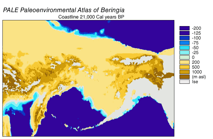
Pont terrestre de la Béringie. Gif animé de sa progression de 21.000 BP (avant présent) aux temps modernes. Voir aussi: Détroit de Béring
| Description | Beringia Land Bridge. Animated gif of its progress from 21.000 BP (before present) to modern times. See also: Bering Strait |
| Date | |
| Source | http://www.ncdc.noaa.gov/paleo/parcs/atlas/beringia/lbridge.html |
| Auteur | NOAA |
| Autorisation (Réutilisation de ce fichier) |
PD-USGov-NOAA |
| Autres versions | http://www.ncdc.noaa.gov/paleo/parcs/atlas/beringia/lbridge.html |
Cette image est dans le domaine public car son contenu provient de la
National Oceanic and Atmospheric Administration , réalisé par un employé dans le cadre de ses activités professionnelles.
|
Historique du fichier
Cliquer sur une date et heure pour voir le fichier tel qu'il était à ce moment-là.
| Date et heure | Vignette | Dimensions | Utilisateur | Commentaire | |
|---|---|---|---|---|---|
| actuel | 9 août 2015 à 04:16 | | 700 × 458 (367 kio) | Leonid 2 (d | contributions) | optimization |
| 4 septembre 2006 à 11:52 |  | 700 × 458 (2,4 Mio) | Roblespepe (d | contributions) | {{Information |Description=Beringia Land Bridge. Animated gif of its progress from 21.000 BC to modern times |Source=http://www.ncdc.noaa.gov/paleo/parcs/atlas/beringia/lbridge.html |Date=1999 |Author=NOAA |Permission=PD-USGov-NOAA |other_versions=http:// |
Vous ne pouvez pas remplacer ce fichier.
Utilisations locales du fichier
Les 2 pages suivantes utilisent ce fichier :
Utilisations du fichier sur d’autres wikis
Les autres wikis suivants utilisent ce fichier :
- Utilisation sur ar.wikipedia.org
- Utilisation sur ast.wikipedia.org
- Utilisation sur avk.wikipedia.org
- Utilisation sur az.wikipedia.org
- Utilisation sur be.wikipedia.org
- Utilisation sur bg.wikipedia.org
- Utilisation sur bn.wikipedia.org
- Utilisation sur ca.wikipedia.org
- Utilisation sur cs.wikipedia.org
- Utilisation sur da.wikipedia.org
- Utilisation sur de.wikipedia.org
- Utilisation sur el.wikipedia.org
- Utilisation sur en.wikipedia.org
- Beringia
- User:World History (Book)
- Talk:Indigenous peoples in Canada/Archive 1
- Wikipedia:Graphics Lab/Map workshop/Archive/Apr 2014
- Beringian wolf
- Pleistocene wolf
- Talk:History of South America/sandbox
- Evolution of the wolf
- Canadian Arctic tundra
- Peopling of the Americas
- User:Alpiniste17/sandbox
- Paleoshoreline
- User:AvaArdito/Paleoshoreline
- Talk:Clovis culture/Archive 1
- Utilisation sur en.wikiversity.org
- Utilisation sur eo.wikipedia.org
- Utilisation sur es.wikipedia.org
Voir davantage sur l’utilisation globale de ce fichier.
Catégories :
- English-language maps
- Animated maps of Northern Asia
- Animated maps of North America
- Bering Strait
- Maps of Siberia
- Pleistocene geography
- Last glacial maximum
- Maps of the history of North America
- Prehistoric Alaska
- Maps of the history of the United States
- Maps of the history of Russia
- Geological maps of Alaska
- Geography of Alaska
- Archaeology in North America
- Pre-Columbian trans-oceanic contact hypotheses
- Maps of the Bering Land Bridge
- Paleoenvironmental maps
- Pleistocene geology of Russia
- Pleistocene geology of Alaska