File:Beringia land bridge-noaagov.gif
ナビゲーションに移動
検索に移動
高解像度版はありません。
Beringia_land_bridge-noaagov.gif (700 × 458 ピクセル、ファイルサイズ: 367キロバイト、MIME タイプ: image/gif、ループします、22 フレーム、24秒)
キャプション
キャプション
このファイルの内容を1行で記述してください
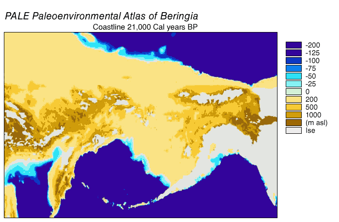
Animated gif of Beringia Land Bridge
| 解説 | Beringia Land Bridge. Animated gif of its progress from 21.000 BP (before present) to modern times. See also: Bering Strait |
| 日付 | |
| 原典 | http://www.ncdc.noaa.gov/paleo/parcs/atlas/beringia/lbridge.html |
| 作者 | NOAA |
| 許可 (ファイルの再利用) |
PD-USGov-NOAA |
| その他のバージョン | http://www.ncdc.noaa.gov/paleo/parcs/atlas/beringia/lbridge.html |
|
|
ファイルの履歴
過去の版のファイルを表示するには、その版の日時をクリックしてください。
| 日付と時刻 | サムネイル | 寸法 | 利用者 | コメント | |
|---|---|---|---|---|---|
| 現在の版 | 2015年8月9日 (日) 04:16 | | 700 × 458 (367キロバイト) | Leonid 2 (トーク | 投稿記録) | optimization |
| 2006年9月4日 (月) 11:52 |  | 700 × 458 (2.4メガバイト) | Roblespepe (トーク | 投稿記録) | {{Information |Description=Beringia Land Bridge. Animated gif of its progress from 21.000 BC to modern times |Source=http://www.ncdc.noaa.gov/paleo/parcs/atlas/beringia/lbridge.html |Date=1999 |Author=NOAA |Permission=PD-USGov-NOAA |other_versions=http:// |
このファイルは上書きできません。
ファイルの使用状況
以下の 2 ページがこのファイルを使用しています:
グローバルなファイル使用状況
以下に挙げる他のウィキがこの画像を使っています:
- ar.wikipedia.org での使用状況
- ast.wikipedia.org での使用状況
- avk.wikipedia.org での使用状況
- az.wikipedia.org での使用状況
- be.wikipedia.org での使用状況
- bg.wikipedia.org での使用状況
- bn.wikipedia.org での使用状況
- ca.wikipedia.org での使用状況
- cs.wikipedia.org での使用状況
- da.wikipedia.org での使用状況
- de.wikipedia.org での使用状況
- el.wikipedia.org での使用状況
- en.wikipedia.org での使用状況
- Beringia
- User:World History (Book)
- Talk:Indigenous peoples in Canada/Archive 1
- Wikipedia:Graphics Lab/Map workshop/Archive/Apr 2014
- Beringian wolf
- Pleistocene wolf
- Talk:History of South America/sandbox
- Evolution of the wolf
- Canadian Arctic tundra
- Peopling of the Americas
- User:Alpiniste17/sandbox
- Paleoshoreline
- User:AvaArdito/Paleoshoreline
- Talk:Clovis culture/Archive 1
- User:Generalissima/History of North America
- en.wikiversity.org での使用状況
- eo.wikipedia.org での使用状況
- es.wikipedia.org での使用状況
このファイルのグローバル使用状況を表示する。
カテゴリ:
- English-language maps
- Animated maps of Northern Asia
- Animated maps of North America
- Bering Strait
- Maps of Siberia
- Pleistocene geography
- Last glacial maximum
- Maps of the history of North America
- Prehistoric Alaska
- Maps of the history of the United States
- Maps of the history of Russia
- Geological maps of Alaska
- Geography of Alaska
- Archaeology in North America
- Pre-Columbian trans-oceanic contact hypotheses
- Maps of the Bering Land Bridge
- Paleoenvironmental maps
- Pleistocene geology of Russia
- Pleistocene geology of Alaska