File:Beringia land bridge-noaagov.gif
Przejdź do nawigacji
Przejdź do wyszukiwania
Grafika w wyższej rozdzielczości nie jest dostępna.
Beringia_land_bridge-noaagov.gif (700 × 458 pikseli, rozmiar pliku: 367 KB, typ MIME: image/gif, zapętlony, 22 klatki, 24 s)
Podpisy
Podpisy
Dodaj jednolinijkowe objaśnienie tego, co ten plik pokazuje
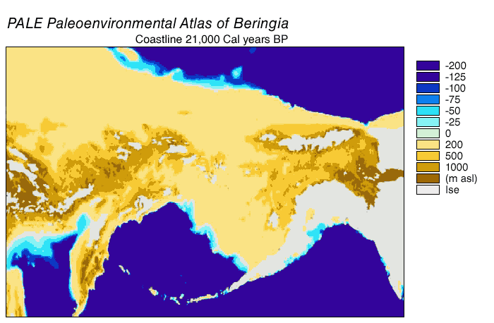
Animated gif of Beringia Land Bridge
| Opis | Beringia Land Bridge. Animated gif of its progress from 21.000 BP (before present) to modern times. See also: Bering Strait |
| Data | |
| Źródło | http://www.ncdc.noaa.gov/paleo/parcs/atlas/beringia/lbridge.html |
| Autor | NOAA |
| Licencja (Ponowne użycie tego pliku) |
PD-USGov-NOAA |
| Inne wersje | http://www.ncdc.noaa.gov/paleo/parcs/atlas/beringia/lbridge.html |
Ta grafika została utworzona przez pracownika Amerykańskiej Narodowej Służby Oceanicznej i Meteorologicznej podczas wykonywania czynności służbowych. Jako utwór Rządu Federalnego Stanów Zjednoczonych, grafika ta znajduje się w domenie publicznej.
|
Historia pliku
Kliknij na odpowiedniej dacie/czasie, aby zobaczyć wersję pliku z tamtego okresu.
| Data/czas | Miniatura | Wymiary | Użytkownik | Opis | |
|---|---|---|---|---|---|
| aktualny | 04:16, 9 sie 2015 | | 700 × 458 (367 KB) | Leonid 2 (dyskusja | edycje) | optimization |
| 11:52, 4 wrz 2006 |  | 700 × 458 (2,4 MB) | Roblespepe (dyskusja | edycje) | {{Information |Description=Beringia Land Bridge. Animated gif of its progress from 21.000 BC to modern times |Source=http://www.ncdc.noaa.gov/paleo/parcs/atlas/beringia/lbridge.html |Date=1999 |Author=NOAA |Permission=PD-USGov-NOAA |other_versions=http:// |
Nie możesz nadpisać tego pliku.
Lokalne wykorzystanie pliku
Następujące strony korzystają z tego pliku:
Globalne wykorzystanie pliku
Ten plik jest wykorzystywany także w innych projektach wiki:
- Wykorzystanie na ar.wikipedia.org
- Wykorzystanie na ast.wikipedia.org
- Wykorzystanie na avk.wikipedia.org
- Wykorzystanie na az.wikipedia.org
- Wykorzystanie na be.wikipedia.org
- Wykorzystanie na bg.wikipedia.org
- Wykorzystanie na bn.wikipedia.org
- Wykorzystanie na ca.wikipedia.org
- Wykorzystanie na cs.wikipedia.org
- Wykorzystanie na da.wikipedia.org
- Wykorzystanie na de.wikipedia.org
- Wykorzystanie na el.wikipedia.org
- Wykorzystanie na en.wikipedia.org
- Beringia
- User:World History (Book)
- Talk:Indigenous peoples in Canada/Archive 1
- Wikipedia:Graphics Lab/Map workshop/Archive/Apr 2014
- Beringian wolf
- Pleistocene wolf
- Talk:History of South America/sandbox
- Evolution of the wolf
- Canadian Arctic tundra
- Peopling of the Americas
- User:Alpiniste17/sandbox
- Paleoshoreline
- User:AvaArdito/Paleoshoreline
- Talk:Clovis culture/Archive 1
- User:Generalissima/History of North America
- Wykorzystanie na en.wikiversity.org
- Wykorzystanie na eo.wikipedia.org
- Wykorzystanie na es.wikipedia.org
Pokaż listę globalnego wykorzystania tego pliku.
Kategorie:
- English-language maps
- Animated maps of Northern Asia
- Animated maps of North America
- Bering Strait
- Maps of Siberia
- Pleistocene geography
- Last glacial maximum
- Maps of the history of North America
- Prehistoric Alaska
- Maps of the history of the United States
- Maps of the history of Russia
- Geological maps of Alaska
- Geography of Alaska
- Archaeology in North America
- Pre-Columbian trans-oceanic contact hypotheses
- Maps of the Bering Land Bridge
- Paleoenvironmental maps
- Pleistocene geology of Russia
- Pleistocene geology of Alaska