File:Bia-map-indian-reservations-usa.png
跳去導覽
跳去搵嘢
預覽大細:800 × 563 像素。 第啲解像度:320 × 225 像素 | 640 × 451 像素 | 1,024 × 721 像素 | 1,280 × 901 像素 | 2,560 × 1,803 像素 | 3,124 × 2,200 像素。
原本檔案 (3,124 × 2,200 像素,檔案大細:457 KB ,MIME類型:image/png)
Captions
Captions
Add a one-line explanation of what this file represents

|
This ethnographic map image could be recreated using vector graphics as an SVG file. This has several advantages; see Commons:Media for cleanup for more information. If an SVG form of this image is already available, please upload it. After uploading an SVG, replace this template with {{vector version available|new image name.svg}}.
|

|
This file has been superseded by Indian reservations in the Continental United States.png. It is recommended to use the other file. Please note that deleting superseded images requires consent. Reason to use the other file: "Updated to include newly-established reservations"
|

|
Source[編輯]
- National Park Service; see also: Bureau of Indian Affairs
Key[編輯]
- 0 No Data
- Absentee Shawnee
- Acoma
- Agua Caliente
- Alabama-Coushatta
- Alabama-Quassarte Creeks
- Allegany
- Apache
- Bad River
- Barona Ranch
- Battle Mountain
- Bay Mills
- Benton Paiute
- Berry Creek
- Big Bend
- Big Cypress
- Big Lagoon
- Big Pine
- Big Valley
- Bishop
- Blackfeet
- Bridgeport
- Brighton
- Burns Paiute Colony
- Cabezon
- Caddo
- Cahuilla
- Campo
- Camp Verde
- Canoncito
- Capitan Grande
- Carson
- Catawba
- Cattaraugus
- Cayuga
- Cedarville
- Chehalis
- Chemehuevi
- Cherokee
- Cheyenne-Arapahoe
- Cheyenne River
- Chickasaw
- Chitimacha
- Choctaw
- Citizen Band Of Potawatomi
- Cochiti
- Coeur D'alene
- Cold Springs
- Colorado River
- Colville
- Comanche
- Coos, Lower Umpqua & Siuslaw
- Coquille
- Cortina
- Coushatta
- Cow Creek
- Creek
- Crow
- Crow Creek
- Cuyapaipe
- Deer Creek
- Delaware
- Devils Lake
- Dresslerville Colony
- Dry Creek
- Duckwater
- Duck Valley
- Eastern Shawnee
- East Cocopah
- Ely Colony
- Enterprise
- Fallon/Stillwater
- Flandreau Indian School
- Flathead
- Fond Du Lac
- Fort Apache
- Fort Belknap
- Fort Berthold
- Fort Bidwell
- Fort Hall
- Fort Independence
- Fort Mcdermitt
- Fort Mcdowell
- Fort Mohave
- Fort Peck
- Fort Yuma
- Ft. Sill Apache
- Gila Bend
- Gila River
- Goshute
- Grande Ronde
- Grand Portage
- Grand Traverse
- Greater Leech Lake
- Grindstone
- Hannahville
- Havasupai
- Hoh
- Hollywood
- Hoopa Valley
- Hopi
- Houlton Maliseets
- Hualapai
- Inaja
- Iowa
- Isabella
- Isleta
- Jackson
- Jemez
- Jicarilla
- Kaibab
- Kalispel
- Kaw
- Kialegee Creek
- Kickapoo
- Kiowa
- Klamath
- Kootenai
- L'anse
- Lac Courte Oreilles
- Lac Du Flambeau
- Lac Vieux Desert
- Laguna
- Las Vegas
- Laytonville
- La Jolla
- La Posta
- Likely
- Lone Pine
- Lookout
- Los Coyotes
- Lovelock Colony
- Lower Brule
- Lower Elwah
- Lower Sioux
- Lummi
- Makah
- Manchester
- Manzanita
- Maricopa
- Mashantucket Pequot
- Mattaponi
- Menominee
- Mescalero
- Miami
- Miccosukee
- Middletown
- Mille Lacs
- Mission
- Moapa
- Modoc
- Mole Lake
- Montgomery Creek
- Morongo
- Muckleshoot
- Nambe
- Narragansett
- Navajo
- Nett Lake
- Nez Perce
- Nipmuc-Hassanamisco
- Nisqually
- Nooksack
- Northern Cheyenne
- Northwestern Shoshone
- Oil Springs
- Omaha
- Oneida
- Onondaga
- Ontonagon
- Osage
- Otoe-Missouri
- Ottawa
- Out
- Ozette
- Paiute
- Pala
- Pamunkey
- Pascua Yaqui
- Passamaquoddy
- Paucatauk Pequot
- Paugusett
- Pawnee
- Pechanga
- Penobscot
- Peoria
- Picuris
- Pine Ridge
- Poarch Creek
- Pojoaque
- Ponca
- Poosepatuck
- Port Gamble
- Port Madison
- Potawatomi
- Prairie Isle
- Puertocito
- Puyallup
- Pyramid Lake
- Quapaw
- Quillayute
- Quinault
- Ramah
- Ramona
- Red Cliff
- Red Lake
- Reno-Sparks
- Rincon
- Roaring Creek
- Rocky Boys
- Rosebud
- Round Valley
- Rumsey
- Sac And Fox
- Salt River
- Sandia
- Sandy Lake
- Santa Ana
- Santa Clara
- Santa Domingo
- Santa Rosa
- Santa Rosa (North)
- Santa Ynez
- Santa Ysabel
- Santee
- San Carlos
- San Felipe
- San Ildefonso
- San Juan
- San Manual
- San Pasqual
- San Xavier
- Sauk Suiattle
- Seminole
- Seneca-Cayuga
- Sequan
- Shagticoke
- Shakopee
- Sheep Ranch
- Sherwood Valley
- Shingle Spring
- Shinnecock
- Shoalwater
- Shoshone
- Siletz
- Sisseton
- Skokomish
- Skull Valley
- Soboba
- Southern Ute
- Spokane
- Squaxon Island
- St. Croix
- St. Regis
- Standing Rock
- Stewarts Point
- Stockbridge Munsee
- Summit Lake
- Susanville
- Swinomish
- Taos
- Te-Moak
- Tesuque
- Texas Kickapoo
- Tohono O'odham
- Tonawanda
- Tonikawa
- Torres Martinez
- Toulumne
- Trindad
- Tulalip
- Tule River
- Tunica-Biloxi
- Turtle Mountains
- Tuscarora
- Twentynine Palms
- Umatilla
- Uintah And Ouray
- United Keetoowah Band Of Cherokee
- Upper Sioux
- Upper Skagit
- Ute Mountain
- Vermilion Lake
- Viejas
- Walker River
- Warm Springs
- Washoe
- West Cocopah
- White Earth
- Wichita
- Wind River
- Winnebago
- Winnemucca
- Woodford Indian Community
- Wyandotte
- Xl Ranch
- Yakama
- Yankton
- Yavapai
- Yerington
- Yomba
- Ysleta Del Sur
- Yurok
- Zia
- Zuni
Info contained in image[編輯]
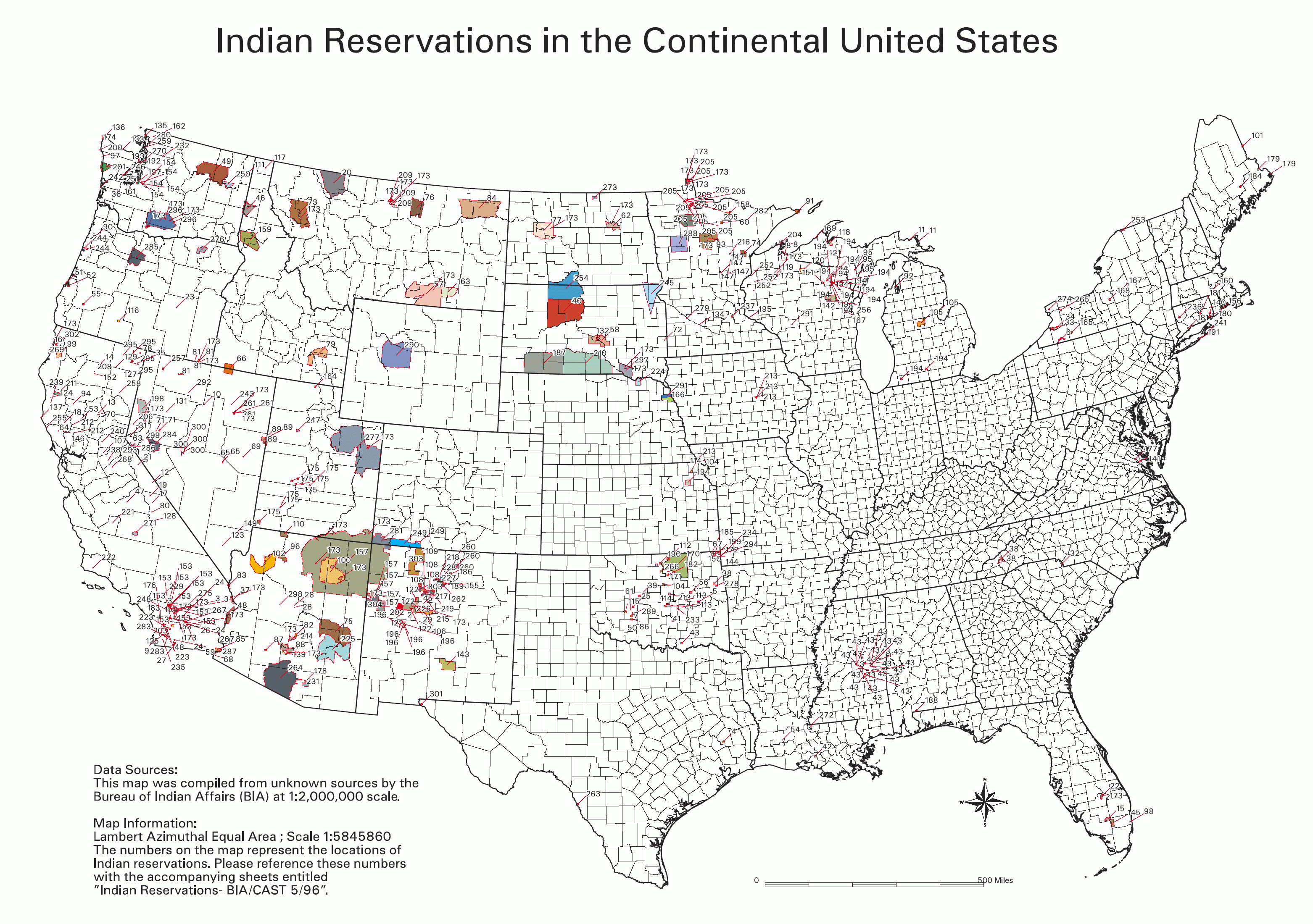
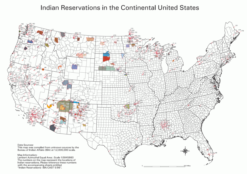
Data Sources: This map was compiled from unknown sources by the Bureau of Indian Affairs (BIA) at 1:2,000,000 scale.
Map Information: Lambert Azimuthal Equal Area; Scale 1:5845860 The numbers on the map represent the locations of Indian reservations. Please reference these numbers with the accompanying sheets entitled Indian Reservations - BIA/CAST 5/96
摘要[編輯]
English: BIA map of Indian Reservations in the Continental United States. An index to the reservations of the map can be found on the National NAGPRA site, http://www.cr.nps.gov/nagpra/. That key is currently at http://www.nps.gov/history/nagpra/documents/ResMapIndex.htm.
協議[編輯]
| This image or media file contains material based on a work of a National Park Service employee, created as part of that person's official duties. As a work of the U.S. federal government, such work is in the public domain in the United States. See the NPS website and NPS copyright policy for more information. |
derivative works[編輯]
Derivative works of this file:
檔案歷史
撳個日期/時間去睇響嗰個時間出現過嘅檔案。
| 日期/時間 | 縮圖 | 尺寸 | 用戶 | 註解 | |
|---|---|---|---|---|---|
| 現時 | 2006年2月1號 (三) 01:06 | | 3,124 × 2,200(457 KB) | Wille Raab~commonswiki(傾偈 | 貢獻) | BIA map of Indian Reservations in the Continental United States. An index to the reservations of the map can be found on the National NAGPRA site, http://www.cr.nps.gov/nagpra/. |
你無得衾咗個檔案。
檔案用途
以下嘅3版用到呢個檔:
全域檔案使用情況
下面嘅維基都用緊呢個檔案:
- af.wikipedia.org嘅使用情況
- ast.wikipedia.org嘅使用情況
- ba.wikipedia.org嘅使用情況
- be.wikipedia.org嘅使用情況
- bg.wikipedia.org嘅使用情況
- ca.wikipedia.org嘅使用情況
- da.wikipedia.org嘅使用情況
- de.wikipedia.org嘅使用情況
- de.wikiversity.org嘅使用情況
- en.wikipedia.org嘅使用情況
- eo.wikipedia.org嘅使用情況
- es.wikipedia.org嘅使用情況
- eu.wikipedia.org嘅使用情況
- fa.wikipedia.org嘅使用情況
- fi.wikipedia.org嘅使用情況
- frr.wikipedia.org嘅使用情況
- fr.wikipedia.org嘅使用情況
- fy.wikipedia.org嘅使用情況
- gl.wikipedia.org嘅使用情況
- he.wikipedia.org嘅使用情況
- hi.wikipedia.org嘅使用情況
- hu.wikipedia.org嘅使用情況
- id.wikipedia.org嘅使用情況
- it.wikipedia.org嘅使用情況
睇呢個檔案嘅更多全域使用情況。