File:Bih IEBLinRed.png
Bih_IEBLinRed.png (329 × 352 Pixel, Dateigröße: 23 KB, MIME-Typ: image/png)
Bildtexte
Kurzbeschreibungen
Beschreibung
[Bearbeiten]

|
Dieses Bild des Typs Historical map sollte als Vektorgrafik im SVG-Format neu erstellt werden. Vektorformate haben zahlreiche Vorteile; weitere Information unter Commons:Media for cleanup. Wenn dir eine SVG-Version dieses Bildes vorliegt, so lade diese bitte hoch. Nach dem Hochladen der Datei ist diese Vorlage auf der aktuellen Bildbeschreibungsseite durch die Vorlage {{Vector version available}}, oder kürzer {{Vva}}, zu ersetzen. Es ist empfohlen die neue SVG-Datei „Bih IEBLinRed.svg“ zu nennen – dann benötigt die Vorlage vector version available (bzw. vva) keinen Parameter.
|
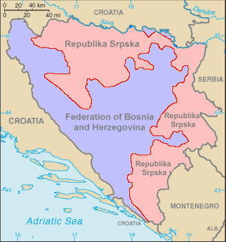
This is a map of Bosnia-Herzegovina (from the World Factbook Archivkopie in der Wayback Machine) with the Inter-Entity Boundary Line (IEBL) in red. The map has been made simpler by removing the names of the cities, leaving only the two entities. Color has added for the entities as well. The labels have also been redone, since they did not show up well against the colors. This map is based off the one in the World Factbook as mirrored by the PCL.
Lizenz
[Bearbeiten]
Ovo je ispravna karta .Zaboravili ste Brcko district je posebna jedinica koje ne pripada nikome a nije oznaceno[1]
![[1]](http://3.bp.blogspot.com/-I8wsRh6MpT4/UPRnAon0eYI/AAAAAAAAAFI/7NnMbKQExvg/s1600/Federalna+struktura+BiH.jpg)
Dieses Werk ist gemeinfrei, weil es Bildmaterial aus dem CIA World Factbook darstellt, das ursprünglich vom Zentralen Nachrichtendienst der Vereinigten Staaten veröffentlicht wurde.
|
 |
Dateiversionen
Klicke auf einen Zeitpunkt, um diese Version zu laden.
| Version vom | Vorschaubild | Maße | Benutzer | Kommentar | |
|---|---|---|---|---|---|
| aktuell | 05:17, 29. Okt. 2006 | | 329 × 352 (23 KB) | Hoshie (Diskussion | Beiträge) | This is a map of Bosnia-Herzegovina (from the [https://www.cia.gov/cia/publications/factbook/maps/bk-map.gif World Factbook]) with the Inter-Entity Boundary Line (IEBL) in red. The map has been made simpler by removing the |
Du kannst diese Datei nicht überschreiben.
Dateiverwendung
Die folgenden 3 Seiten verwenden diese Datei:
Globale Dateiverwendung
Die nachfolgenden anderen Wikis verwenden diese Datei:
- Verwendung auf de.wikipedia.org
- Verwendung auf sr.wikipedia.org
- Verwendung auf vec.wikipedia.org