File:Biot-map.png
跳至導覽
跳至搜尋

無更高解析度可提供。
Biot-map.png (328 × 353 像素,檔案大小:5 KB,MIME 類型:image/png)
說明
說明
添加單行說明來描述出檔案所代表的內容

|
本圖片是以PNG、GIF或JPEG格式上傳。然而,其中包含的資料或訊息,應該重新建立成可縮放向量圖形(SVG)檔案,以更有效率或更準確的方式儲存。如有可能,請上傳本圖片的SVG格式版本。在上傳之後,請修改維基各姊妹計畫中所有使用舊版圖片的條目(列在圖像連結章節中),替換為新版圖片,並在舊圖片的描述頁中加入{{Vector version available|新圖片名稱.svg}}模板,同時移除本模板。
|
Transferred from en.wikipedia to Commons by Maksim.
The original description page was here. All following user names refer to en.wikipedia.
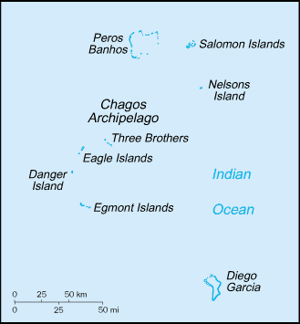
Map of the British Indian Ocean Territory from CIA World Factbook.
|
|
 |
| date/time | username | edit summary |
|---|---|---|
| 22:56, 12 November 2004 | en:User:BrokenSegue | ({{PD-USGov-CIA-WF}}) |
| 06:17, 4 June 2004 | en:User:Template namespace initialisation script | |
| 20:15, 23 May 2004 | en:User:Grendelkhan | (clear up PD message) |
| 20:14, 23 May 2004 | en:User:Grendelkhan | (Map of the British Indian Ocean Territory from [http://www.lib.utexas.edu/maps/cia03/british_indian_ocean_sm03.gif CIA World Factbook].<br><br>{{msg:PD}}) |
原始上傳日誌
[編輯]
Legend: (cur) = this is the current file, (del) = delete this old version, (rev) = revert to this old version.
Click on date to download the file or see the image uploaded on that date.
- (del) (cur) 22:14, 24 May 2005 . . en:User:Hoshie Hoshie ( en:User_talk:Hoshie Talk) . . 328x353 (4977 bytes) (updated map from 2005 CIA World Factbook, now with a lowercase file name.)
- (del) (rev) 20:14, 23 May 2004 . . en:User:Grendelkhan Grendelkhan ( en:User_talk:Grendelkhan Talk) . . 329x355 (4794 bytes) (Map of the British Indian Ocean Territory from CIA World Factbook.<br><br>{ { msg:PD } })
檔案歷史
點選日期/時間以檢視該時間的檔案版本。
| 日期/時間 | 縮圖 | 尺寸 | 用戶 | 備註 | |
|---|---|---|---|---|---|
| 目前 | 2006年5月12日 (五) 21:11 | | 328 × 353(5 KB) | Frankie Roberto~commonswiki(對話 | 貢獻) | Map of the British Indian Ocean Territory from [http://www.lib.utexas.edu/maps/cia03/british_indian_ocean_sm03.gif CIA World Factbook]. {{PD-USGov-CIA-WF}} (copied from http://en.wikipedia.org/wiki/Image:Biot-map.png for use on Wikinews) |
| 2006年3月26日 (日) 11:13 |  | 328 × 353(5 KB) | Maksim(對話 | 貢獻) | La bildo estas kopiita de wikipedia:en. La originala priskribo estas: Map of the British Indian Ocean Territory from [http://www.lib.utexas.edu/maps/cia03/british_indian_ocean_sm03.gif CIA World Factbook]. {{PD-USGov-CIA-WF}} {| border="1" ! date/time |
無法覆蓋此檔案。
檔案用途
下列5個頁面有用到此檔案:
全域檔案使用狀況
以下其他 wiki 使用了這個檔案:
- af.wikipedia.org 的使用狀況
- arz.wikipedia.org 的使用狀況
- ast.wikipedia.org 的使用狀況
- bs.wikipedia.org 的使用狀況
- ca.wikipedia.org 的使用狀況
- da.wikipedia.org 的使用狀況
- de.wikipedia.org 的使用狀況
- el.wikipedia.org 的使用狀況
- en.wikipedia.org 的使用狀況
- en.wikinews.org 的使用狀況
- eo.wikipedia.org 的使用狀況
- es.wikipedia.org 的使用狀況
- fa.wikipedia.org 的使用狀況
- fr.wikipedia.org 的使用狀況
- ga.wikipedia.org 的使用狀況
- gl.wikipedia.org 的使用狀況
- hr.wikipedia.org 的使用狀況
- hu.wikipedia.org 的使用狀況
- incubator.wikimedia.org 的使用狀況
- it.wikipedia.org 的使用狀況
- ja.wikipedia.org 的使用狀況
- ko.wikipedia.org 的使用狀況
- lij.wikipedia.org 的使用狀況
- lt.wikipedia.org 的使用狀況
- mzn.wikipedia.org 的使用狀況
- nl.wikipedia.org 的使用狀況
- pl.wikipedia.org 的使用狀況
- pt.wikipedia.org 的使用狀況
- ro.wikipedia.org 的使用狀況
- ru.wikipedia.org 的使用狀況
檢視此檔案的更多全域使用狀況。