File:Black Sea map-sv.png
Ir a la navegación
Ir a la búsqueda
Kay ñawpaq qhawariypa chhikan kaynin: 786 × 599 iñu. Huk huyakukuna: 315 × 240 iñu | 630 × 480 iñu | 1007 × 768 iñu | 1200 × 915 iñu.
Qallariy willañiqi (1200 × 915 iñu; willañiqip chhikan kaynin: 315 kB; MIME laya: image/png)
Leyendas
Leyendas
Añade una explicación corta acerca de lo que representa este archivo
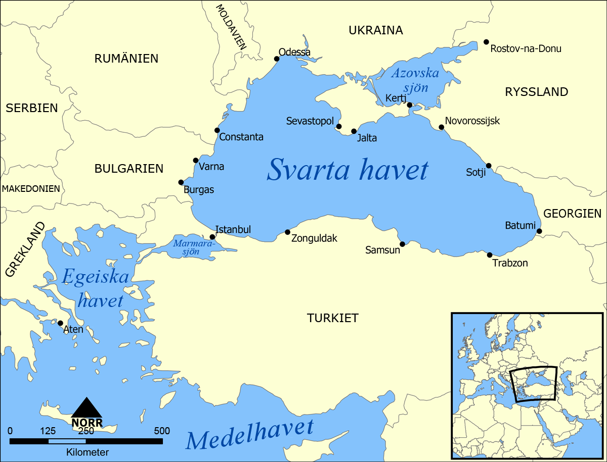
| T'iktuna | A map showing the location of the Black Sea and some of the large or prominent ports around it. The Sea of Azov and Sea of Marmara are also labelled. |
| P'unchaw | (UTC) |
| Pukyu | |
| Ruraq |
|
| Huk musuqchasqakuna |
[]
|


.png)


| Esta es una imagen retocada, lo que significa que ha sido alterada digitalmente de su versión original. La original se puede ver aquí: Black Sea map.png.
|
Ñuqaqa, kay rurasqaypa iskaychay hayñiyuq kaqnin, kaywan rurasqayta uyaychachkanim kay qatiq saqillaykunawan:
| Kay willañiqiqa Creative Commons nisqap kay hinallataq rakinakuy 3.0 mana apasqa saqillayninwanmi saqillasqa. | ||
| ||
| Kay saqillay unanchachaqa GFDL saqillay musuqchaywanmi kay willañiqiman yapasqa. |

|
Saqillayqa huñikusqam kay atiqllata iskaychaypaq, mast'ariypaq icha wakinchaypaq kay saqillaypa phatankunakama: GNU Free Documentation License, musuqchasqa 1.2 icha ima qhipaqnin kaq musuqchasqapas Free Software Foundation nisqap uyaychasqan; mana "mana wakinchana rakinakuna", "ñawpaq qata p'anqa" icha "qhipaq qata p'anqa" nisqa qillqayuq. Saqillaypa iskaychasqanqa GNU Free Documentation License nisqa rakipi ch'aqtasqam. |
Munasqayki saqillayta akllariy.
Qallariy churkuy hallch'a
[llamk'apuy]
This image is a derivative work of the following images:
- File:Black_Sea_map.png licensed with Cc-by-sa-3.0-migrated, GFDL
- 2007-07-10T18:10:36Z NormanEinstein 1200x915 (382990 Bytes) Updated maps to add Russian city of Sochi.
- 2007-05-07T19:11:11Z NormanEinstein 1200x912 (378400 Bytes) Corrected city name typo.
- 2006-05-29T13:10:42Z NormanEinstein 1200x914 (136455 Bytes) Reduced image size.
- 2005-07-25T14:54:05Z NormanEinstein 1200x916 (487643 Bytes) A map showing the location of the Black Sea and some of the large or prominent ports around it. The Sea of Azov and Sea of Maramara are also labelled. Created by NormanEinstein, July 25, 2005. {{GFDL-self}} [[Category:Maps
Uploaded with derivativeFX
Willañiqip wiñay kawsaynin
P'unchaw/pacha nisqapi ñit'iy chaypacha willañiqi kachkasqata qhawanaykipaq.
| P'unchaw/Pacha | Uchuylla rikchacha | Chhikanyachikuqkuna | Ruraq | Willapuy | |
|---|---|---|---|---|---|
| kunan | 18:22 21 awr 2010 | | 1200 × 915 (315 kB) | Inteloutside2 (rimanakuy | llamk'apusqakuna) | {{Information |Description=A map showing the location of the Black Sea and some of the large or prominent ports around it. The Sea of Azov and Sea of Marmara are also labelled. |Source=*File:Black_Sea_map.png |Date=2010-04-21 18:22 (UTC) |Author=*[[ |
Manam atinkichu kay willañiqita huknachayta.
Maypim willañiqita llamk'achinku
Kay rikchamanqa kay qatiq 18 p'anqakunam t'inkimun:
- File:Black Sea map-ar.png
- File:Black Sea map-de.png
- File:Black Sea map-sv.png
- File:Black Sea map-tr.png
- File:Black Sea map-zh.png
- File:Black Sea map.png
- File:Black Sea map blank.png
- File:Black Sea map he.png
- File:Black Sea map he (cropped).png
- File:Black Sea map hr.svg
- File:Black Sea map ku.png
- File:Black Sea map lld.png
- File:Black Sea map ta.png
- File:Mer Noire (carte).png
- File:Morze Czarne mapa pl.png
- File:Zwarte Zee.png
- File:ΜαύρηΘάλασσα.PNG
- Template:Other versions/Black Sea map
.png)
Mayqin wikikunapi willañiqita llamk'achinku
Kay wakin wikikunam willañiqitaqa llamk'achinku:
- ka.wiktionary.org-pi kaykunapi llamk'achinku
- sv.wikipedia.org-pi kaykunapi llamk'achinku