File:Borderless countries.PNG
跳至導覽
跳至搜尋
預覽大小:800 × 370 像素。 其他解析度:320 × 148 像素 | 640 × 296 像素 | 1,357 × 628 像素。
原始檔案 (1,357 × 628 像素,檔案大小:29 KB,MIME 類型:image/png)
說明
說明
添加單行說明來描述出檔案所代表的內容

|
File:Borderless countries.svg是本檔案的向量版本。 如果品質不低,就應該優先使用該檔案,而非PNG檔案。
File:Borderless countries.PNG → File:Borderless countries.svg
更多資訊請參閱Help:SVG/zh。 |
 |
摘要[編輯]
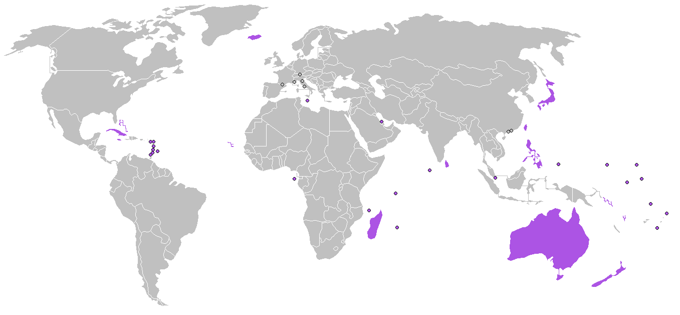
| 描述 | Map of the world, locating borderless countries (purple) as listed on w:Borderless country. |
| 來源 | own work, based on File:BlankMap-World.png |
| 作者 | edited by Roke |
授權條款[編輯]
我,本作品的著作權持有者,決定用以下授權條款發佈本作品:

|
已授權您依據自由軟體基金會發行的無固定段落、封面文字和封底文字GNU自由文件授權條款1.2版或任意後續版本,對本檔進行複製、傳播和/或修改。該協議的副本列在GNU自由文件授權條款中。 |
| 此檔案採用共享創意 姓名標示-相同方式分享 3.0 未在地化版本授權條款。 | ||
| ||
| 已新增授權條款標題至此檔案,作為GFDL授權更新的一部份。 |
您可以選擇您需要的授權條款。
檔案歷史
點選日期/時間以檢視該時間的檔案版本。
| 日期/時間 | 縮圖 | 尺寸 | 用戶 | 備註 | |
|---|---|---|---|---|---|
| 目前 | 2014年12月23日 (二) 20:10 | | 1,357 × 628(29 KB) | Inops(對話 | 貢獻) | rm Cyprus; it has borders with en:Akrotiri and Dhekelia |
| 2013年8月26日 (一) 22:29 |  | 1,357 × 628(36 KB) | Coinmanj(對話 | 貢獻) | Bahamas is a borderless country | |
| 2007年12月28日 (五) 05:01 |  | 1,357 × 628(46 KB) | Hoshie(對話 | 貢獻) | added Cabinda (Angola) and Montenegro. Under same. | |
| 2007年8月27日 (一) 21:37 |  | 1,357 × 628(46 KB) | Luis wiki(對話 | 貢獻) | Australia is a Borderless country. | |
| 2007年8月23日 (四) 14:22 |  | 1,357 × 628(26 KB) | Yath~commonswiki(對話 | 貢獻) | ||
| 2006年3月3日 (五) 05:41 |  | 1,357 × 628(46 KB) | Roke~commonswiki(對話 | 貢獻) | Borderless countries as listed on w:Borderless country |
無法覆蓋此檔案。
檔案用途
沒有使用此檔案的頁面。
全域檔案使用狀況
以下其他 wiki 使用了這個檔案:
- ar.wikipedia.org 的使用狀況
- ary.wikipedia.org 的使用狀況
- az.wikipedia.org 的使用狀況
- de.wikipedia.org 的使用狀況
- eo.wikipedia.org 的使用狀況
- fr.wikipedia.org 的使用狀況
- hu.wikipedia.org 的使用狀況
- is.wikipedia.org 的使用狀況
- it.wikipedia.org 的使用狀況
- ja.wikipedia.org 的使用狀況
- ka.wikipedia.org 的使用狀況
- ko.wikipedia.org 的使用狀況
- la.wikipedia.org 的使用狀況
- lv.wikipedia.org 的使用狀況
- nn.wikipedia.org 的使用狀況
- pa.wikipedia.org 的使用狀況
- pnb.wikipedia.org 的使用狀況
- te.wikipedia.org 的使用狀況
- th.wikipedia.org 的使用狀況
- tr.wikipedia.org 的使用狀況
- ur.wikipedia.org 的使用狀況
- vec.wikipedia.org 的使用狀況
- vi.wikipedia.org 的使用狀況
- yo.wikipedia.org 的使用狀況
- zh.wikipedia.org 的使用狀況
詮釋資料
分類:
- Locator maps of islands
- Locator maps of countries of North America (gray scheme)
- Locator maps of countries of Asia (gray scheme)
- Locator maps of countries of Europe (gray scheme)
- Locator maps of countries of Oceania (gray scheme)
- Locator maps of countries of Africa (gray scheme)
- Locator maps of countries of South America (gray scheme)
- Maps of the world with small regions drawn as circles