File:Borders of the Historical Habsburgian Lands in the Republic of Slovenia.png
ナビゲーションに移動
検索に移動

このプレビューのサイズ: 800 × 555 ピクセル。 その他の解像度: 320 × 222 ピクセル | 640 × 444 ピクセル | 919 × 637 ピクセル。
元のファイル (919 × 637 ピクセル、ファイルサイズ: 49キロバイト、MIME タイプ: image/png)
キャプション
キャプション
このファイルの内容を1行で記述してください

概要[編集]
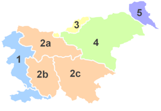
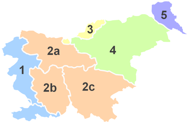
No. |
English |
||
| 1 | Littoral * | Primorska | Küstenland |
| 2 | Carniola | Kranjska | Krain |
| 2a | Upper Carniola | Gorenjska | Oberkrain |
| 2b | Inner Carniola | Notranjska | Innerkrain |
| 2c | Lower Carniola and White Carniola |
Dolenjska in Bela krajina |
Unterkrain und Weißkrain |
| 3 | Carinthia | Koroška | Kärnten |
| 4 | Styria | (Spodnja) Štajerska |
Untersteiermark |
| 5 | Prekmurje ** | Übermurgebiet ** | |
*Littoral used to be part of the historical Austrian Littoral.
**Prekmurje was not part of the historical Austrian crownland, but belonged to the Hungarian crown.

|
このファイルのベクター画像 (SVG) が利用できます。 このビットマップ画像はベクター画像に置き換えられるべきです。
File:Borders of the Historical Habsburgian Lands in the Republic of Slovenia.png → File:Borders of the Historical Habsburgian Lands in the Republic of Slovenia.svg
|
 |
ライセンス[編集]

|
この文書は、フリーソフトウェア財団発行のGNUフリー文書利用許諾書 (GNU Free Documentation License) 1.2またはそれ以降のバージョンの規約に基づき、複製や再配布、改変が許可されます。不可変更部分、表紙、背表紙はありません。このライセンスの複製は、GNUフリー文書利用許諾書という章に含まれています。 |
| このファイルはクリエイティブ・コモンズ 表示-継承 3.0 非移植ライセンスのもとに利用を許諾されています。 | ||
| ||
| このライセンスのテンプレートは、GFDLのライセンス・アップデートによりこのファイルに追加されたものです。 |
ファイルの履歴
過去の版のファイルを表示するには、その版の日時をクリックしてください。
| 日付と時刻 | サムネイル | 寸法 | 利用者 | コメント | |
|---|---|---|---|---|---|
| 現在の版 | 2012年12月18日 (火) 15:28 | | 919 × 637 (49キロバイト) | DancingPhilosopher (トーク | 投稿記録) | color |
| 2012年12月18日 (火) 15:24 |  | 919 × 637 (49キロバイト) | DancingPhilosopher (トーク | 投稿記録) | color | |
| 2012年12月17日 (月) 13:41 |  | 915 × 608 (46キロバイト) | DancingPhilosopher (トーク | 投稿記録) | Corrected boundaries | |
| 2005年7月19日 (火) 22:22 |  | 400 × 289 (30キロバイト) | Besednjak~commonswiki (トーク | 投稿記録) | Austrian Crownlands in todays Slovenia. 1: Primorska/Küstenland, 2: Kranjsko/Krain (Carniola), 2a: Gorenjska/Oberkrain (Upper Carniola), 2b: Notranjska/Innerkrain (Inner Carniola), 2c: Dolenjska/Unterkrain (Lower Carniola), 3: Koroška/Kärnten (Carinthi |
このファイルは上書きできません。
ファイルの使用状況
以下のページがこのファイルを使用しています:
- File:Kronlander Slowenien.png (リダイレクト)
グローバルなファイル使用状況
以下に挙げる他のウィキがこの画像を使っています:
- an.wikipedia.org での使用状況
- ar.wikipedia.org での使用状況
- ast.wikipedia.org での使用状況
- be.wikipedia.org での使用状況
- br.wikipedia.org での使用状況
- ca.wikipedia.org での使用状況
- cs.wikipedia.org での使用状況
- cy.wikipedia.org での使用状況
- en.wikipedia.org での使用状況
- et.wikipedia.org での使用状況
- eu.wikipedia.org での使用状況
- fi.wikipedia.org での使用状況
- fr.wikipedia.org での使用状況
このファイルのグローバル使用状況を表示する。