File:Boryspil International Airport Kyiv.jpg
跳至導覽
跳至搜尋

預覽大小:800 × 534 像素。 其他解析度:320 × 213 像素 | 640 × 427 像素 | 1,024 × 683 像素 | 1,280 × 854 像素 | 2,560 × 1,707 像素 | 7,678 × 5,121 像素。
原始檔案 (7,678 × 5,121 像素,檔案大小:14.08 MB,MIME 類型:image/jpeg)
說明
說明
添加單行說明來描述出檔案所代表的內容
摘要
[編輯]| 描述 |
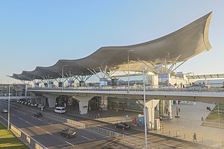
English: Terminal D, Boryspil International Airport, Ukraine |
|||||||||||||||||
| 日期 | ||||||||||||||||||
| 來源 |
|
|||||||||||||||||
| 作者 |
|
|||||||||||||||||
| 授權許可 (重用此檔案) |
I published this file as author under the Creative Commons License CC-by-SA-3.0.. This means that a ‘free use outside Wikimedia’s projects’ is only possible under the following conditions:
I would be very grateful if you could send me a specimen copy of the photo/map or the details of the website where the photo/map will be used. Basically, all my photos and maps can be licensed under the conditions of the Mittelstandsgemeinschaft Foto-Marketing (MFM). Please send an email to lizenz AT arne-mueseler.de if you
Arne Müseler / www.arne-mueseler.com,此作品的版權所有人,決定用以下授權條款發佈本作品: 此檔案採用創用CC 姓名標示-相同方式分享 3.0 德國授權條款。 姓名標示: Arne Müseler / www.arne-mueseler.com
 |
|||||||||||||||||

| 拍攝地點 | | 位於此地的本圖片與其他圖片: OpenStreetMap |
|---|
檔案歷史
點選日期/時間以檢視該時間的檔案版本。
| 日期/時間 | 縮圖 | 尺寸 | 使用者 | 備註 | |
|---|---|---|---|---|---|
| 目前 | 2021年12月23日 (四) 10:54 | | 7,678 × 5,121(14.08 MB) | Arne Müseler(留言 | 貢獻) | {{Information |Description= {{en|1=Terminal D, Boryspil International Airport, Ukraine}} |Source=*own work *http://www.arne-mueseler.com |Date=2021-10-26 |source={{own}} |Author={{User:Arne mueseler/Autor}} |Permission={{Template:ArneMueselerCredit}} |other_versions= }} {{Location|50|21|6.02|N|30|53|47.73|E}} Category:Terminal D of Boryspil International Airport Category:Ukraine - Photographs by Arne Müseler |
無法覆蓋此檔案。
檔案用途
沒有使用此檔案的頁面。
全域檔案使用狀況
以下其他 wiki 使用了這個檔案:
- de.wikipedia.org 的使用狀況
- en.wikipedia.org 的使用狀況
- es.wikipedia.org 的使用狀況
- fr.wikipedia.org 的使用狀況
- he.wikipedia.org 的使用狀況
- id.wikipedia.org 的使用狀況
- it.wikipedia.org 的使用狀況
- nl.wikipedia.org 的使用狀況
- pt.wikipedia.org 的使用狀況
- ru.wikipedia.org 的使用狀況
- sv.wikipedia.org 的使用狀況
- tr.wikipedia.org 的使用狀況
- uk.wikipedia.org 的使用狀況
- uz.wikipedia.org 的使用狀況
- zh.wikipedia.org 的使用狀況