File:Bowen Mexico or New Spain 1752 UTA.jpg
Aller à la navigation
Aller à la recherche
Taille de cet aperçu : 716 × 599 pixels. Autres résolutions : 287 × 240 pixels | 574 × 480 pixels | 918 × 768 pixels | 1 223 × 1 024 pixels | 2 447 × 2 048 pixels | 2 664 × 2 230 pixels.
Fichier d’origine (2 664 × 2 230 pixels, taille du fichier : 7,49 Mio, type MIME : image/jpeg)
Légendes
Légendes
Ajoutez en une ligne la description de ce que représente ce fichier
Description[modifier]
| Titre |
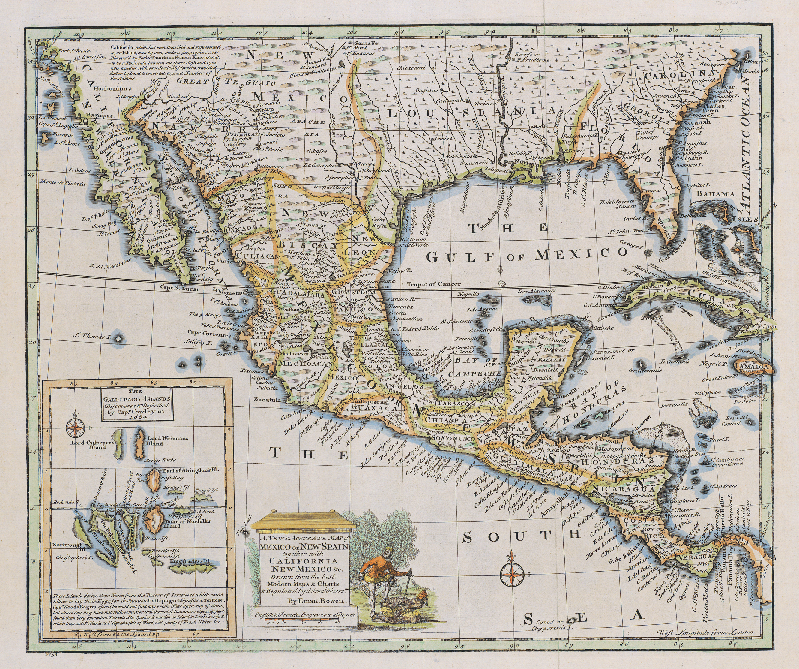
English: A New & Accurate Map of Mexico or New Spain together with California, New Mexico &c |
||||||||||||||||||||||||||
| Description |
English: The cartouche of this map of New Spain depicts a European mishandling a couple of Native American captives. The image dates at least back to 1729 when Peter Van der Aa included an identical image on his cartouche of a map of Mexico or New Spain appearing in Abraham du Bois' La Geographie Moderne, published in Leiden at that date. Such images, repeated over and over, contributed to the Spanish "Black Legend" – the idea that the Spanish treated Indians worse than their Anglo-Protestant peers, many of whom behaved equally bad in reality. Bowen's inset depicts the Galápagos Islands based upon descriptions and charts by English sea captains William A. Cowley and Woodes Rogers. Despite the "modern" scientific jargon with reference to "astronomical observations", English engraver, cartographer, publisher and print-seller Emanuel Bowen, even as Geographer to His Majesty, did not have access to accurate field information for much of the territories depicted – no one would until the mid-nineteenth century. His map shows Santa Fe along the 101st meridian instead of its actual location along the 105th, with the result that New Mexico lies four degrees of longitude east of its true location, and the area of present west Texas is considerably condensed. |
||||||||||||||||||||||||||
| Date | |||||||||||||||||||||||||||
| Source | UTA Libraries Cartographic Connections: carte / texte | ||||||||||||||||||||||||||
| Créé par |
|
||||||||||||||||||||||||||
| Attribution de l’acquisition |
English: The University of Texas at Arlington Libraries Special Collections, Gift of Virginia Garrett |
||||||||||||||||||||||||||
| Données géotemporelles | |||||||||||||||||||||||||||
| Lieu |
Mexique Nouvelle-Espagne |
||||||||||||||||||||||||||
| Géoréférencement | Si c'est inapproprié, définissez warp_status = skip pour masquer. | ||||||||||||||||||||||||||
| Données bibliographiques | |||||||||||||||||||||||||||
| Auteur |
|
||||||||||||||||||||||||||
| Lieu de publication | Londres | ||||||||||||||||||||||||||
| Données d'archives | |||||||||||||||||||||||||||
| Collection |
|
||||||||||||||||||||||||||
| Dimensions | hauteur : 36 cm ; largeur : 43 cm | ||||||||||||||||||||||||||
| Technique / matériaux |
gravure colorée sur papier eau-forte colorée sur papier |
||||||||||||||||||||||||||
| Inscriptions |
English: Drawn from the best Modern Maps & Charts & Regulated by Astronl. Observns. |
||||||||||||||||||||||||||
| artwork-references | Huseman, Ben W. (2016) Enlightenment Mapmakers and the Southwest Borderlands, Arlington : The University of Texas at Arlington Libraries, nº47 , p. 37 | ||||||||||||||||||||||||||

Conditions d’utilisation[modifier]

|
This file was provided to Wikimedia Commons by the University of Texas at Arlington Libraries as part of a cooperation project. The University of Texas at Arlington Libraries is part of the University of Texas at Arlington, a public research university located in Arlington, Texas.
|
|
L’auteur est mort en 1767 ; cette œuvre est donc également dans le domaine public dans tous les pays pour lesquels le droit d’auteur a une durée de vie de 100 ans ou moins après la mort de l’auteur. Cette œuvre est dans le domaine public aux États-Unis car elle a été publiée avant le 1er janvier 1929. | |
| Ce fichier a été identifié comme étant exempt de restrictions connues liées au droit d’auteur, y compris tous les droits connexes et voisins. | |
Historique du fichier
Cliquer sur une date et heure pour voir le fichier tel qu'il était à ce moment-là.
| Date et heure | Vignette | Dimensions | Utilisateur | Commentaire | |
|---|---|---|---|---|---|
| actuel | 3 juillet 2019 à 21:25 | | 2 664 × 2 230 (7,49 Mio) | Michael Barera (d | contributions) | == {{int:filedesc}} == {{Map |title = ''A New & Accurate Map of Mexico or New Spain together with California, New Mexico &c'' |description = {{en|The cartouche of this map of New Spain depicts a European mishandling a couple of Native American captives. The image dates at least back to 1729 when Peter Van der Aa included an identical image on his cartouche of a map of Mexico or New Spain appearing in Abraham du Bois' ''La Geographie Moderne'', published in Leiden at that d... |
Vous ne pouvez pas remplacer ce fichier.
Utilisations locales du fichier
Aucune page n’utilise ce fichier.
Utilisations du fichier sur d’autres wikis
Les autres wikis suivants utilisent ce fichier :
- Utilisation sur de.wikipedia.org
- Utilisation sur en.wikipedia.org
- Utilisation sur es.wikipedia.org
- Utilisation sur fr.wikipedia.org
- Utilisation sur hr.wikipedia.org
- Utilisation sur la.wikipedia.org