File:Br-map1.jpg
跳至導覽
跳至搜尋
無更高解析度可提供。
Br-map1.jpg (330 × 354 像素,檔案大小:34 KB,MIME 類型:image/jpeg)
說明
說明
添加單行說明來描述出檔案所代表的內容
| 描述 |
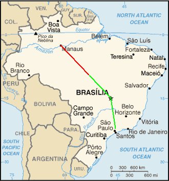
English: Map of Brazil showing the presumed flight paths of Gol Transportes Aéreos Flight 1907 and the Embraer Legacy 600 aircraft that it collided with to the crash site (source: CENIPA Final report)
|
||||||||
| 日期 | |||||||||
| 來源 | Derivative work of File:Brazil-CIA_WFB_Map.png | ||||||||
| 作者 | Crum375 (talk) | ||||||||
| 授權許可 (重用此檔案) |
|

檔案歷史
點選日期/時間以檢視該時間的檔案版本。
| 日期/時間 | 縮圖 | 尺寸 | 用戶 | 備註 | |
|---|---|---|---|---|---|
| 目前 | 2006年10月6日 (五) 17:21 | | 330 × 354(34 KB) | Xamã~commonswiki(對話 | 貢獻) | Original was Br-map.gif from WikiCommmons, placed crash coords 10.29S 53.15W, drew lines between Sao Paulo, Manaus and Brasilia, to crash coord location, per GoogleMaps as reference |
無法覆蓋此檔案。
檔案用途
沒有使用此檔案的頁面。
全域檔案使用狀況
以下其他 wiki 使用了這個檔案:
- de.wikipedia.org 的使用狀況
- en.wikipedia.org 的使用狀況
- es.wikipedia.org 的使用狀況
- fr.wikipedia.org 的使用狀況
- it.wikipedia.org 的使用狀況
- ja.wikipedia.org 的使用狀況
- nl.wikipedia.org 的使用狀況
- pt.wikipedia.org 的使用狀況
- ru.wikipedia.org 的使用狀況
- zh.wikipedia.org 的使用狀況