File:Brands Hatch.svg
跳转到导航
跳转到搜索

此SVG文件的PNG预览的大小:493 × 600像素。 其他分辨率:197 × 240像素 | 395 × 480像素 | 631 × 768像素 | 842 × 1,024像素 | 1,684 × 2,048像素 | 1,198 × 1,457像素。
原始文件 (SVG文件,尺寸为1,198 × 1,457像素,文件大小:53 KB)
说明
说明
添加一行文字以描述该文件所表现的内容
摘要
[编辑]| 描述 |
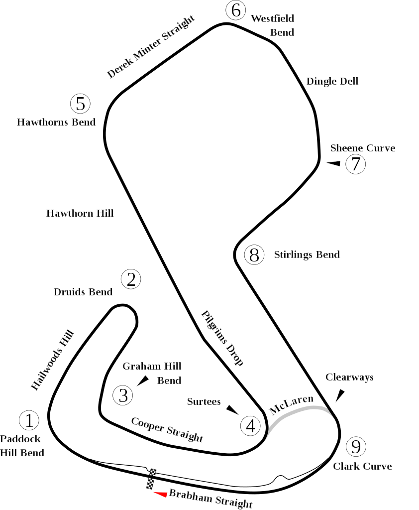
English: Track map of Brands Hatch. |
| 日期 | |
| 来源 | 自己的作品 |
| 作者 | Will Pittenger |
| 其他版本 |
|

| 相机位置 | | 在以下服务上查看本图像和附近其他图像: OpenStreetMap |
|---|
许可协议
[编辑]
| 我,本作品著作权人,释出本作品至公有领域。这适用于全世界。 在一些国家这可能不合法;如果是这样的话,那么: 我无条件地授予任何人以任何目的使用本作品的权利,除非这些条件是法律规定所必需的。 |
文件历史
点击某个日期/时间查看对应时刻的文件。
| 日期/时间 | 缩略图 | 大小 | 用户 | 备注 | |
|---|---|---|---|---|---|
| 当前 | 2012年7月7日 (六) 15:10 | | 1,198 × 1,457(53 KB) | Aegidian(留言 | 贡献) | Very minor correction to text at Hailwoods Hill. |
| 2012年7月7日 (六) 15:04 |  | 1,198 × 1,457(54 KB) | Aegidian(留言 | 贡献) | Minor corrections to the names of Hawthorns Bend and Derek Minter straight, removal of old Dingle Dell Corner and replacement with current Sheene Curve. | |
| 2008年7月15日 (二) 06:44 |  | 1,198 × 1,457(54 KB) | Will Pittenger(留言 | 贡献) | This new version gets around a Mediawiki bug that prevents it from handing Text on paths correctly. It does so by converting such text into path objects. If you need to edit the text in question, please use the previous version. | |
| 2008年7月15日 (二) 06:40 |  | 1,198 × 1,457(45 KB) | Will Pittenger(留言 | 贡献) | {{Information |Description={{en|1=Track map of w:Brands Hatch.}} |Source=Own work by uploader |Author=Will Pittenger |Date=7-15-2008 |Permission= |other_versions=<gallery>Image:Brands Hatch.png|PNG version for those with brows |
您不可以覆盖此文件。
文件用途
全域文件用途
以下其他wiki使用此文件:
- af.wikipedia.org上的用途
- ar.wikipedia.org上的用途
- ast.wikipedia.org上的用途
- bg.wikipedia.org上的用途
- bn.wikipedia.org上的用途
- br.wikipedia.org上的用途
- en.wikipedia.org上的用途
- List of A1 Grand Prix circuits
- User talk:Chubbennaitor/archive2
- User talk:Barkjon/Archive 2
- Wikipedia:WikiProject Formula One/Newsletter/200808
- User talk:Hellboy2hell/archive2
- User talk:NapHit/Archive 1
- User talk:4u1e/archive5
- User talk:Typ932/Archive 3
- User talk:Midgrid/Archive 6
- Formula Ford Festival
- User talk:Thelb4/Archive 5
- User talk:Chubbennaitor/Archive7
- User talk:Readro/Archive 3
- Rothmans 50,000
- User talk:Donnie Park/Archive 1
- User talk:The359/Archive 4
- List of Superleague Formula circuits
- 2009 Brands Hatch Formula Two round
- User talk:Cs-wolves/Archive 3
- User talk:Bam123456789/Archive 1
- 2010 Brands Hatch Formula Two round
- User talk:Sage Callahan/Archive 1
- User talk:Cdhaptomos/Archive 1
- User:FactualCollector7d1/sandbox
- User talk:Spenalzo/Archive/2008
- User talk:Clyde1998/Archive/2008
- es.wikipedia.org上的用途
- eu.wikipedia.org上的用途
- fa.wikipedia.org上的用途
- fi.wikipedia.org上的用途
- fr.wikipedia.org上的用途
查看此文件的更多全域用途。