File:Bread street ward and Cordwainer ward 1720 john stow with streets highlighted.jpg
Fichier d’origine (1 059 × 612 pixels, taille du fichier : 249 kio, type MIME : image/jpeg)
Légendes
Légendes
| Description |
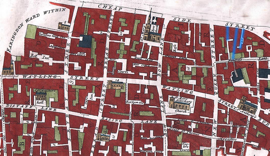
English: The Wards of Breadstreet and Cordwainer
The overlaid streets are from Holt, Richard; Baker, Nigel (2001), Lynne Bevan, ed., Indecent Exposure - sexuality, society and the archaeological record - Prostitution in English Medieval Towns, Glasgow: Cruithne Press, ISBN 1-873448-19-8Including Bow Lane, Friday Street, New Queen St., Watling St, Distaff Lane and Budge Row. Grope Countelane in the middle (blue) is bordered by Bordhawlane on the right, and Puppekirtylane on the left. Although these streets are mostly gone, the map does demonstrate the number of narrow streets in the area. The 1720 map is from John Stow (John Strype, editor), Survey of the Cities of London and Westminster London, 1720, 2 volumes |
| Date | |
| Source | http://www.oldlondonmaps.com/stowpages/broad.html |
| Auteur | John Stow |
Conditions d’utilisation
[modifier]
|
Cette œuvre est également dans le domaine public dans tous les pays pour lesquels le droit d’auteur a une durée de vie de 100 ans ou moins après la mort de l’auteur. Cette œuvre est dans le domaine public aux États-Unis car elle a été publiée avant le 1er janvier 1929. | |
| Ce fichier a été identifié comme étant exempt de restrictions connues liées au droit d’auteur, y compris tous les droits connexes et voisins. | |
Historique du fichier
Cliquer sur une date et heure pour voir le fichier tel qu'il était à ce moment-là.
| Date et heure | Vignette | Dimensions | Utilisateur | Commentaire | |
|---|---|---|---|---|---|
| actuel | 21 avril 2009 à 13:37 | | 1 059 × 612 (249 kio) | Parrot of Doom (d | contributions) | {{Information |Description={{en|1=== Summary == {{Information |Description={{en|1=The Wards of Breadstreet and Cordwainer Including Bow Lane, Friday Street, New Queen St., Watling St, Distaff Lane and Budge Row from John Stow (John Strype, editor), Surv |
Vous ne pouvez pas remplacer ce fichier.
Utilisations locales du fichier
Aucune page n’utilise ce fichier.
Utilisations du fichier sur d’autres wikis
Les autres wikis suivants utilisent ce fichier :
- Utilisation sur en.wikipedia.org
- Utilisation sur es.wikipedia.org
- Utilisation sur fr.wikipedia.org
- Utilisation sur it.wikipedia.org
- Utilisation sur ja.wikipedia.org
- Utilisation sur pt.wikipedia.org
- Utilisation sur www.wikidata.org