File:Bridge in West Wheatfield Township.jpg
Pumunta sa nabigasyon
Pumunta sa paghahanap

Laki ng pasilip na ito: 800 x 565 na pixel. Ibang resolusyon: 320 x 226 na pixel | 640 x 452 na pixel | 802 x 566 na pixel.
Orihinal na file (802 × 566 na pixel, laki: 65 KB, uri ng MIME: image/jpeg)
Captions
Captions
Add a one-line explanation of what this file represents
|
This is an image of a place or building that is listed on the National Register of Historic Places in the United States of America. Its reference number is 88000774. |
| Camera location | | View this and other nearby images on: OpenStreetMap |
|---|
| Paglalarawan |
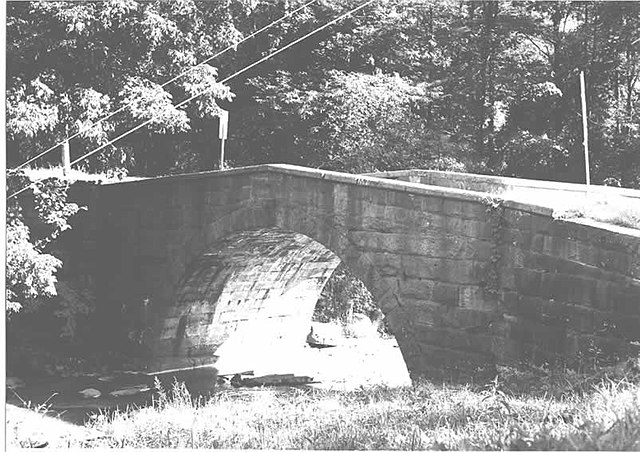
English: Side of the Bridge in West Wheatfield Township, which carries Legislative Route 32008 over Richards Run near Robinson in West Wheatfield Township, Indiana County, Pennsylvania, United States. Built in 1911, the bridge is listed on the National Register of Historic Places. |
|||
| Petsa | ||||
| Pinanggalingan | "Bridge in West Wheatfield Township" (National Register of Historic Places form). National Park Service (June 22, 1988). Photo from http://www.arch.state.pa.us, searchable database, at http://www.arch.state.pa.us/images/hires/H000097_01B.jpg | |||
| May-akda | PennDOT | |||
| Permiso (Muling paggamit sa file) |
|

Nakaraan ng file
Pindutin ang isang petsa/oras para makita ang file noong puntong yon.
| Petsa/Oras | Thumbnail | Sukat | Tagagamit | Komento | |
|---|---|---|---|---|---|
| ngayon | 15:11, 8 Disyembre 2009 | | 802 × 566 (65 KB) | Nyttend (usapan | ambag) | {{Location|40|24|11|N|79|7|45|W}} {{Information |Description={{en|Side of the {{w|Bridge in West Wheatfield Township}}, which carries Legislative Route 32008 over Richards Run near {{w|Robinson, Pennsylvania|Robinson}} in {{w|West Wheatfield Township, Ind |
Hindi mo mao-overwrite ang file na ito.
Paggamit sa file
Ginagamit ng sumusunod na pahina ang file na ito:
Pandaigdigang paggamit sa file
Ginagamit ng mga sumusunod na wiki ang file na ito:
- Paggamit sa cy.wikipedia.org
- Paggamit sa en.wikipedia.org
- Paggamit sa es.wikipedia.org
- Paggamit sa fr.wikipedia.org
- Paggamit sa tl.wikipedia.org
- Paggamit sa uk.wikipedia.org
- Paggamit sa ur.wikipedia.org
- Paggamit sa vi.wikipedia.org
- Paggamit sa www.wikidata.org
Metadata
Mga kategorya:
- Photographs by Pennsylvania Department of Transportation
- Built in Pennsylvania in 1911
- Bridges in the United States completed in 1911
- 1910s bridges in Pennsylvania
- Bridges on the National Register of Historic Places in Pennsylvania
- National Register of Historic Places in Indiana County, Pennsylvania
- Bridges in Indiana County, Pennsylvania
- Stone arch bridges in Pennsylvania
- West Wheatfield Township, Indiana County, Pennsylvania