File:British Virgin Islands.jpg
Spring til navigation
Spring til søgning

Størrelse af denne forhåndsvisning: 800 × 533 pixels. Andre opløsninger: 320 × 213 pixels | 640 × 427 pixels | 1.024 × 683 pixels | 1.280 × 853 pixels | 2.700 × 1.800 pixels.
Oprindelig fil (2.700 × 1.800 billedpunkter, filstørrelse: 2,89 MB, MIME-type: image/jpeg)
Captions
Captions
Tilføj en kort forklaring på en enkelt linje om hvad filen viser
Beskrivelse[redigér]
| Beskrivelse |
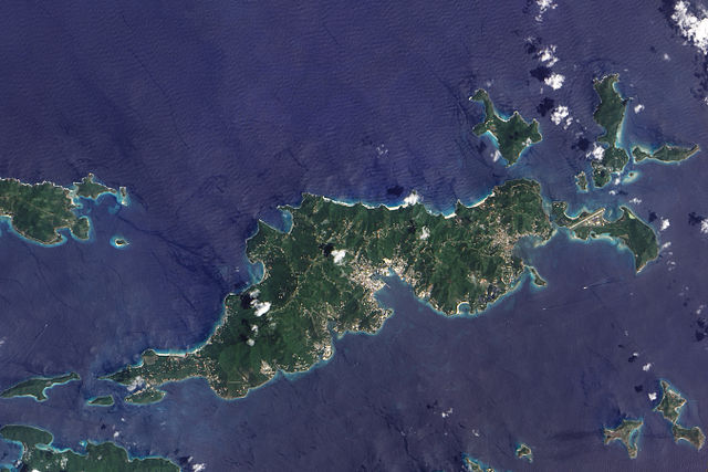
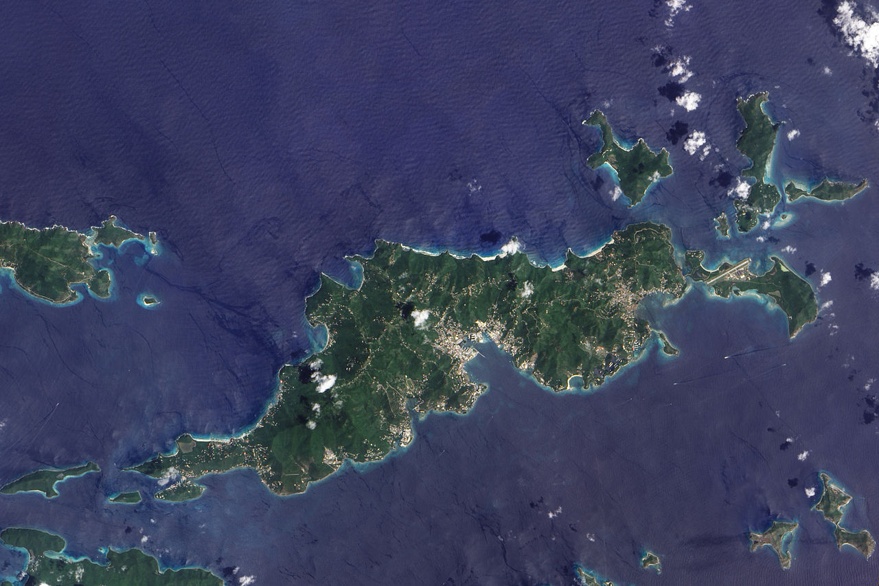
English: This true-colour image of Tortola and its smaller neighbours, Guana Island, Grand Camanoe, and Beef Island. The islands follow a roughly south-west-north-east trajectory. Gray-beige urbanized areas cling to the coast while Tortola’s interior remains mostly green, an arrangement driven by the islands’s topography. The biggest settlement fringes Road Bay. A straight line crossing Beef Island gives away the location of a small airport. Tortola’s carpet of green suggests a lush rainforest, but the island actually supports a patch of drought-resistant forest, in addition to plants accustomed to more water. Tortola’s climate and land surface are well suited to raising livestock, but tourism and financial services are the primary industries. |
| Dato | |
| Kilde | NASA Earth Observatory |
| Forfatter | Jesse Allen |
Image captured by the Advanced Land Imager (ALI) on NASA’s Earth Observing-1 (EO-1) satellite. Image created using EO-1 ALI data provided courtesy of the NASA EO-1 team and the United States Geological Survey. Instrument: EO-1 - ALI.
Licensering[redigér]
| Denne fil er i offentligt domæne i USA fordi den udelukkende er skabt af NASA. NASAs ophavsretspolitik erklærer at materiale udgivet af NASA ikke er omfattet af ophavsret medmindre andet er nævnt. (Se også Template:PD-USGov, NASAs ophavsretspolitik eller JPLs politik for brug af billeder.) | ||
 |
Advarsler:
|
| Annotations | This image is annotated: View the annotations at Commons |
Filhistorik
Klik på en dato/tid for at se filen som den så ud på det tidspunkt.
| Dato/tid | Miniaturebillede | Dimensioner | Bruger | Kommentar | |
|---|---|---|---|---|---|
| nuværende | 30. nov. 2009, 12:06 | | 2.700 × 1.800 (2,89 MB) | Originalwana (diskussion | bidrag) | {{Information |Description={{en|1=This true-colour image of Tortola and its smaller neighbours, Guana Island, Grand Camanoe, and Beef Island. The islands follow a roughly south-west-north-east trajectory. Gray-beige urbanized areas c |
Du kan ikke overskrive denne fil.
Filanvendelse
De følgende 26 sider bruger denne fil:
- British Virgin Islands
- Category:1975 in the British Virgin Islands
- Category:2001 in the British Virgin Islands
- Category:2003 in the British Virgin Islands
- Category:2004 in the British Virgin Islands
- Category:2006 in the British Virgin Islands
- Category:2007 in the British Virgin Islands
- Category:2008 in the British Virgin Islands
- Category:2009 in the British Virgin Islands
- Category:2011 in the British Virgin Islands
- Category:2012 in the British Virgin Islands
- Category:2013 in the British Virgin Islands
- Category:Athletics in the British Virgin Islands
- Category:British Virgin Islands
- Category:British Virgin Islands by century
- Category:British Virgin Islands by decade
- Category:British Virgin Islands by year
- Category:British Virgin Islands in the 2000s
- Category:British Virgin Islands in the 2010s
- Category:British Virgin Islands in the 21st century
- Category:Infrastructure in the British Virgin Islands
- Category:Islands of the British Virgin Islands
- Category:Kitesurfing in the British Virgin Islands
- Category:Landforms of the British Virgin Islands
- Category:Religion in the British Virgin Islands
- Category:Transport infrastructure in the British Virgin Islands
Global filanvendelse
Følgende andre wikier anvender denne fil:
- Anvendelser på af.wikipedia.org
- Anvendelser på ar.wikipedia.org
- Anvendelser på arz.wikipedia.org
- Anvendelser på ast.wikipedia.org
- Anvendelser på ca.wikipedia.org
- Anvendelser på cy.wikipedia.org
- Anvendelser på da.wikipedia.org
- Anvendelser på en.wikipedia.org
- Anvendelser på eo.wikipedia.org
- Anvendelser på fr.wikivoyage.org
- Anvendelser på ga.wikipedia.org
- Anvendelser på gl.wikipedia.org
- Anvendelser på ht.wikipedia.org
- Anvendelser på pap.wikipedia.org
- Anvendelser på pl.wikipedia.org
- Anvendelser på ru.wikinews.org
- Anvendelser på tl.wikipedia.org
- Anvendelser på tt.wikipedia.org
- Anvendelser på uk.wikipedia.org
- Anvendelser på vec.wikipedia.org
- Anvendelser på www.wikidata.org