File:British Virgin Islands.jpg
Zur Navigation springen
Zur Suche springen

Größe dieser Vorschau: 800 × 533 Pixel. Weitere Auflösungen: 320 × 213 Pixel | 640 × 427 Pixel | 1.024 × 683 Pixel | 1.280 × 853 Pixel | 2.700 × 1.800 Pixel.
Originaldatei (2.700 × 1.800 Pixel, Dateigröße: 2,89 MB, MIME-Typ: image/jpeg)
Bildtexte
Kurzbeschreibungen
Ergänze eine einzeilige Erklärung, was diese Datei darstellt.
Beschreibung[Bearbeiten]
| Beschreibung |
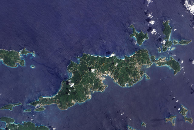
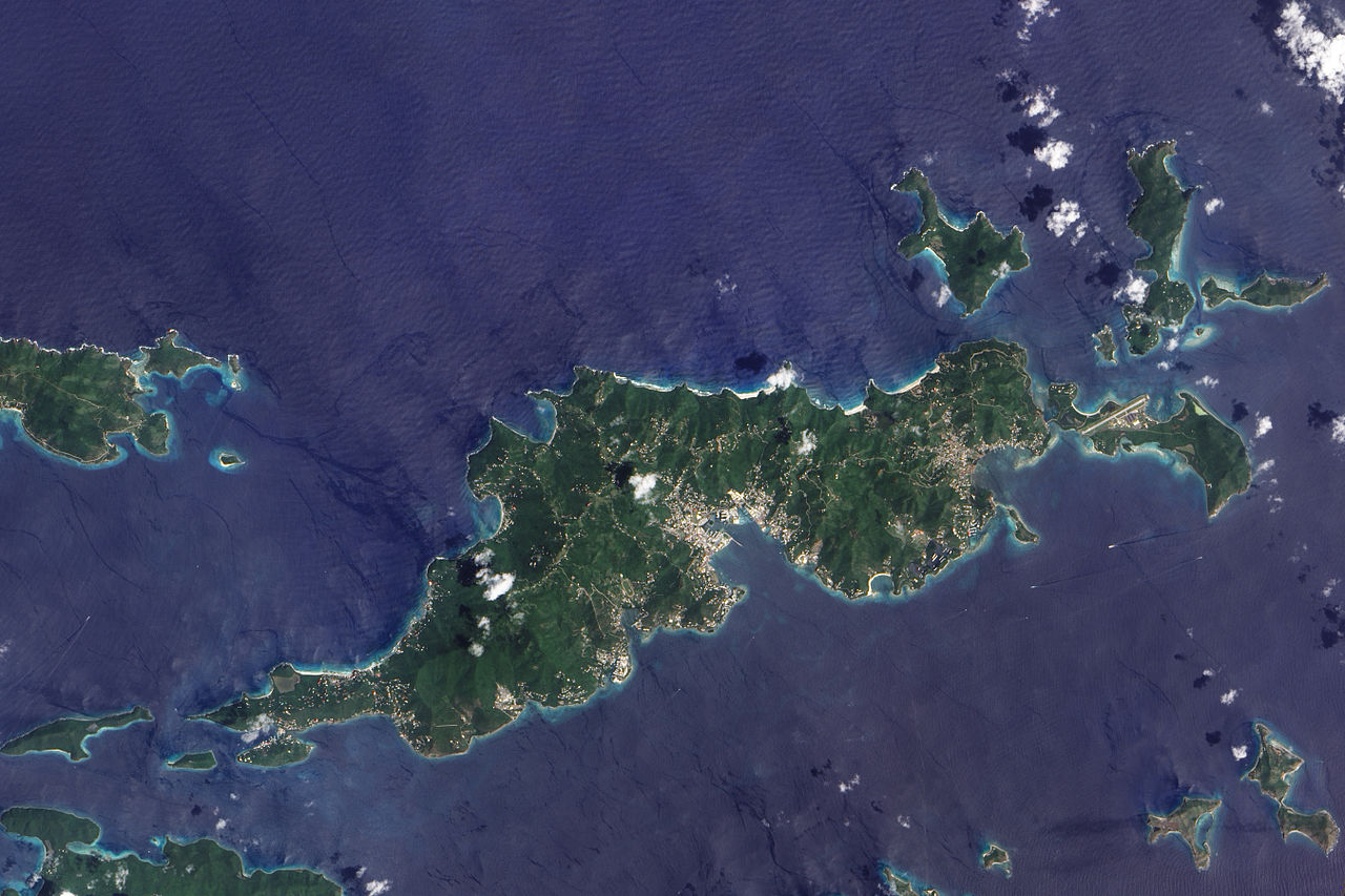
English: This true-colour image of Tortola and its smaller neighbours, Guana Island, Grand Camanoe, and Beef Island. The islands follow a roughly south-west-north-east trajectory. Gray-beige urbanized areas cling to the coast while Tortola’s interior remains mostly green, an arrangement driven by the islands’s topography. The biggest settlement fringes Road Bay. A straight line crossing Beef Island gives away the location of a small airport. Tortola’s carpet of green suggests a lush rainforest, but the island actually supports a patch of drought-resistant forest, in addition to plants accustomed to more water. Tortola’s climate and land surface are well suited to raising livestock, but tourism and financial services are the primary industries. |
| Datum | |
| Quelle | NASA Earth Observatory |
| Urheber | Jesse Allen |
Image captured by the Advanced Land Imager (ALI) on NASA’s Earth Observing-1 (EO-1) satellite. Image created using EO-1 ALI data provided courtesy of the NASA EO-1 team and the United States Geological Survey. Instrument: EO-1 - ALI.
Lizenz[Bearbeiten]
| Diese Datei ist gemeinfrei (public domain), da sie von der NASA erstellt worden ist. Die NASA-Urheberrechtsrichtlinie besagt, dass „NASA-Material nicht durch Urheberrecht geschützt ist, wenn es nicht anders angegeben ist“. (NASA-Urheberrechtsrichtlinie-Seite oder JPL Image Use Policy). | ||
 |
Warnung:
|
| Bildnotizen | Diese Datei ist annotiert: Betrachte diese auf Commons. |
Dateiversionen
Klicke auf einen Zeitpunkt, um diese Version zu laden.
| Version vom | Vorschaubild | Maße | Benutzer | Kommentar | |
|---|---|---|---|---|---|
| aktuell | 12:06, 30. Nov. 2009 | | 2.700 × 1.800 (2,89 MB) | Originalwana (Diskussion | Beiträge) | {{Information |Description={{en|1=This true-colour image of Tortola and its smaller neighbours, Guana Island, Grand Camanoe, and Beef Island. The islands follow a roughly south-west-north-east trajectory. Gray-beige urbanized areas c |
Du kannst diese Datei nicht überschreiben.
Dateiverwendung
Die folgenden 26 Seiten verwenden diese Datei:
- British Virgin Islands
- Category:1975 in the British Virgin Islands
- Category:2001 in the British Virgin Islands
- Category:2003 in the British Virgin Islands
- Category:2004 in the British Virgin Islands
- Category:2006 in the British Virgin Islands
- Category:2007 in the British Virgin Islands
- Category:2008 in the British Virgin Islands
- Category:2009 in the British Virgin Islands
- Category:2011 in the British Virgin Islands
- Category:2012 in the British Virgin Islands
- Category:2013 in the British Virgin Islands
- Category:Athletics in the British Virgin Islands
- Category:British Virgin Islands
- Category:British Virgin Islands by century
- Category:British Virgin Islands by decade
- Category:British Virgin Islands by year
- Category:British Virgin Islands in the 2000s
- Category:British Virgin Islands in the 2010s
- Category:British Virgin Islands in the 21st century
- Category:Infrastructure in the British Virgin Islands
- Category:Islands of the British Virgin Islands
- Category:Kitesurfing in the British Virgin Islands
- Category:Landforms of the British Virgin Islands
- Category:Religion in the British Virgin Islands
- Category:Transport infrastructure in the British Virgin Islands
Globale Dateiverwendung
Die nachfolgenden anderen Wikis verwenden diese Datei:
- Verwendung auf af.wikipedia.org
- Verwendung auf ar.wikipedia.org
- Verwendung auf arz.wikipedia.org
- Verwendung auf ast.wikipedia.org
- Verwendung auf ca.wikipedia.org
- Verwendung auf cy.wikipedia.org
- Verwendung auf da.wikipedia.org
- Verwendung auf en.wikipedia.org
- Verwendung auf eo.wikipedia.org
- Verwendung auf fr.wikivoyage.org
- Verwendung auf ga.wikipedia.org
- Verwendung auf gl.wikipedia.org
- Verwendung auf ht.wikipedia.org
- Verwendung auf pap.wikipedia.org
- Verwendung auf pl.wikipedia.org
- Verwendung auf ru.wikinews.org
- Verwendung auf tl.wikipedia.org
- Verwendung auf tt.wikipedia.org
- Verwendung auf uk.wikipedia.org
- Verwendung auf vec.wikipedia.org
- Verwendung auf www.wikidata.org