File:Britonia6hcentury.png
Zur Navigation springen
Zur Suche springen

Greßi vu däre Vorschau: 342 × 600 Pixel. Wyteri Ufflösige: 137 × 240 Pixel | 274 × 480 Pixel | 438 × 768 Pixel | 584 × 1.024 Pixel | 1.670 × 2.928 Pixel.
Originaldatei (1.670 × 2.928 Pixel, Dateigrößi: 542 KB, MIME-Typ: image/png)
Bildtexte
Kurzbeschreibungen
Ergänze eine einzeilige Erklärung, was diese Datei darstellt.

|
Please translate the English parts of this template into Alemannisch.
Säll Bild gitt's au in als Vektorgrafik (SVG). Wenn's besser isch, no benutz säll anstell vu dem Rasterbild. File:Britonia6hcentury.png → File:Britonia6hcentury2.svg
Meh zu Vektorgrafike findsch unter Wechsel zu SVG. Zu de Unterstützig vu SVG durch d'MediaWiki-Software lüeg unter SVG image support uff Meta. |
 |
References[ändere]
- Young, Simon (2005) A.D. 500: A Journey through the Dark Isles of Britain and Ireland, Weidenfeld & Nicolson ISBN: 0297848054. - p.17 and map on p.15
Bschryybig[ändere]
| Bschryybig |
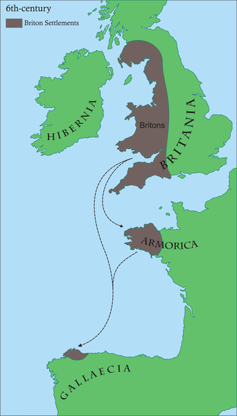
Français : Carte des régions d'Europe occidentale ayant des communautés Brythonic au 6ème siècle après JC
English: Map of areas in western Europe with Brythonic communities for the 6th century AD Galego: Mapa dos asentamentos britónicos no occidente europeo arredor do século VI da nosa era.
Os territorios aparecen en marrón, mentres o verde indica a situación xeográfica. |
| Datum | |
| Quälle | Eigeni Arbet |
| Urheber | Rubén Tarrío |
| Gnähmigung (Wyternutzig vu däre Datei) |
own work |
Lizänzierig[ändere]
| Ich, dr Urheberrächtsinhaber vu däm Wärch, tue s as gmeinfrej vereffentlige . Des giltet wältwyt. In mänke Staate chennt des rächtli nit megli syy. Wänn des imfall eso isch: Ich gib e jedem s bedingiglos Rächt, des Wärch jedwädere Zwäck z nutze, ußer s git gesetzlig erforderligi Bedingige. |
Dateiversione
Klick uf e Zytpunkt zu aazeige, wie s dert usgsäh het.
| Version vom | Vorschaubild | Mäß | Benutzer | Kommentar | |
|---|---|---|---|---|---|
| aktuell | 08:45, 17. Jun. 2008 | | 1.670 × 2.928 (542 KB) | Le Galicien (Diskussion | Byträg) | {{Information |Description={{gl|1=Mapa dos asentamentos britónicos no occidente europeo arredor do século VI da nosa era. Os territorios aparecen en marrón, mentres o verde indica a situación xeográfica.}} |Source=Own work by uploader |Author=Rubén |
Du chasch die Datei nit iberschryybe.
Verwändig vu dr Datei
Die Syte bruucht die Datei:
Wältwyti Dateinutzig
Die andere Wikis bruche die Datei:
- Gebruch uf af.wikipedia.org
- Gebruch uf als.wikipedia.org
- Gebruch uf an.wikipedia.org
- Gebruch uf arz.wikipedia.org
- Gebruch uf ast.wikipedia.org
- Gebruch uf azb.wikipedia.org
- Gebruch uf be.wikipedia.org
- Gebruch uf bg.wikipedia.org
- Gebruch uf bn.wikipedia.org
- Gebruch uf br.wikipedia.org
- Gebruch uf ca.wikipedia.org
- Gebruch uf cs.wikipedia.org
- Gebruch uf cy.wikipedia.org
- Gebruch uf el.wikipedia.org
- Gebruch uf en.wikipedia.org
- 510
- Brittany
- Romano-British culture
- Armorica
- History of Brittany
- Celtic Britons
- History of Galicia
- Kingdom of the Suebi
- Bretons
- User talk:SPQRobin
- Timeline of Cornish history
- User talk:Chzz/Archive 11
- Wikipedia:Reference desk/Archives/Humanities/2011 April 29
- User:Ibonarzua/sandbox/Wikipedia improvement2
- User:Anuragngoel/Romano-British culture
- Gebruch uf es.wikipedia.org
Wältwyti Verwändig vu däre Datei aaluege.