File:Broadside of maps and views of Admiral Edward Vernon's capture of Portobello, Panama, during the War of Jenkins' Ear 35134 (cropped).jpg
Aller à la navigation
Aller à la recherche

Taille de cet aperçu : 800 × 430 pixels. Autres résolutions : 320 × 172 pixels | 640 × 344 pixels | 1 416 × 761 pixels.
Fichier d’origine (1 416 × 761 pixels, taille du fichier : 1,37 Mio, type MIME : image/jpeg)
Légendes
Légendes
Ajoutez en une ligne la description de ce que représente ce fichier
Description[modifier]
| Description |
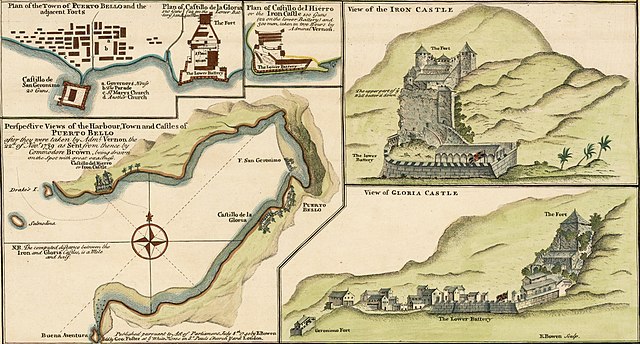
English: Perspective Views of the Harbour, Town and Castles of Puerto Bello (Portobelo), after they were taken by Admiral Vernon the 22nd Nov 1739 as sent from thence by Commodore Brown. Extracted from: A Sequel of the Seat of War in the West Indies containing (1) a Map of the Isthmus of Panama exhibiting the Roads with the Course of the River Châgre thro the same (2) Curious Perspective Views of the Harbour, Town and Castles of Puerto Bello, as sent over by Commodore Brown (3) the Appearance at Sea of San Juan de Puerto Rico with it's Castles / from Admiral Vernon's own draught, the whole illustrated with remarks.
Español: Vistas en perspectiva del puerto, la ciudad y los castillos de Puerto Bello (Portobelo), después de que fueran tomadas por el almirante Vernon el 22 de noviembre de 1739. Tomado de A Sequel of the Seat of War in the West Indies. |
| Date | |
| Source | https://www.raremaps.com/gallery/detail/35134/panama---battle-of-portobello-and-the-war-of-jenkins-ear-bowen |
| Auteur | Edward Vernon, Emanuel Bowen (1694-1767) |
| Autres versions |

.jpg&action=edit§ion=1)
Conditions d’utilisation[modifier]
.jpg&action=edit§ion=2)
|
Cette œuvre est également dans le domaine public dans tous les pays pour lesquels le droit d’auteur a une durée de vie de 100 ans ou moins après la mort de l’auteur. Cette œuvre est dans le domaine public aux États-Unis car elle a été publiée avant le 1er janvier 1929. | |
| Ce fichier a été identifié comme étant exempt de restrictions connues liées au droit d’auteur, y compris tous les droits connexes et voisins. | |
Historique du fichier
Cliquer sur une date et heure pour voir le fichier tel qu'il était à ce moment-là.
| Date et heure | Vignette | Dimensions | Utilisateur | Commentaire | |
|---|---|---|---|---|---|
| actuel | 11 avril 2022 à 22:16 | | 1 416 × 761 (1,37 Mio) | Arjuno3 (d | contributions) | File:Broadside of maps and views of Admiral Edward Vernon's capture of Portobello, Panama, during the War of Jenkins' Ear 35134.jpg cropped 9 % horizontally, 62 % vertically using CropTool with precise mode. |
Vous ne pouvez pas remplacer ce fichier.
Utilisations locales du fichier
Les 2 pages suivantes utilisent ce fichier :
Utilisations du fichier sur d’autres wikis
Les autres wikis suivants utilisent ce fichier :
- Utilisation sur de.wikipedia.org
- Utilisation sur es.wikipedia.org
- Utilisation sur fi.wikipedia.org
- Utilisation sur fr.wikipedia.org
.jpg&oldid=834639622)