File:Burmese-Siamese war (1765-1767) map - EN - 001.jpg
跳至導覽
跳至搜尋

預覽大小:342 × 599 像素。 其他解析度:137 × 240 像素 | 274 × 480 像素 | 438 × 768 像素 | 584 × 1,024 像素 | 1,516 × 2,657 像素。
原始檔案 (1,516 × 2,657 像素,檔案大小:461 KB,MIME 類型:image/jpeg)
說明
說明
添加單行說明來描述出檔案所代表的內容
摘要
[編輯]| 描述 |
English:
ไทย:
|
| 日期 | |
| 來源 |
自己的作品
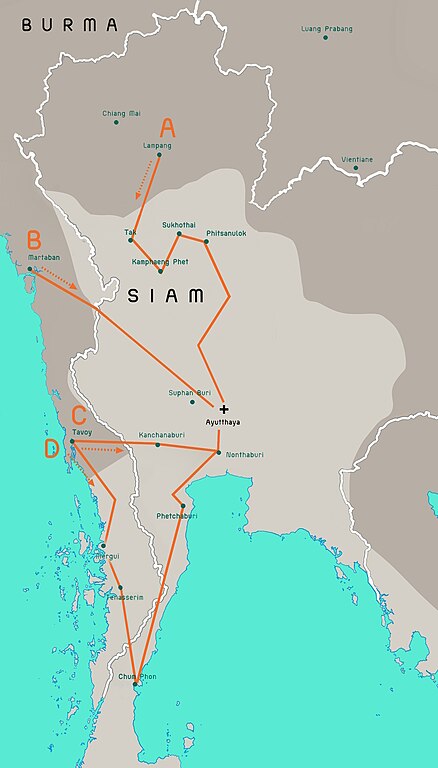
Terwiel, Bertrand. Thailand's Political History: From the 13th Century to Recent Times. Approximate boundaries of the six states that formed after Ayutthaya's destruction. |
| 作者 | Aristitleism |
| 其他版本 |
_map_-_TH_-_002.jpg) |
授權條款
[編輯]我,本作品的著作權持有者,決定用以下授權條款發佈本作品:
| 此檔案在創用CC CC0 1.0 通用公有領域貢獻宣告之下分發。 | |
| 在此宣告之下分發本作品者,已依據各國著作權法,在全世界放棄其對本作品所擁有的著作權及所有相關相似的法律權利,從而將本作品貢獻至公有領域。您可以複製、修改、分發和演示該作品,用於任何商業用途,所有這些都不需要請求授權。
|
en:Burmese–Siamese War (1765–1767)

|
本圖片是以PNG、GIF或JPEG格式上傳。然而,其中包含的資料或訊息,應該重新建立成可縮放向量圖形(SVG)檔案,以更有效率或更準確的方式儲存。如有可能,請上傳本圖片的SVG格式版本。在上傳之後,請修改維基各姊妹計畫中所有使用舊版圖片的條目(列在圖像連結章節中),替換為新版圖片,並在舊圖片的描述頁中加入{{Vector version available|新圖片名稱.svg}}模板,同時移除本模板。
|


_map_-_EN_-_001.jpg&action=edit§ion=1)
_map_-_EN_-_001.jpg&action=edit§ion=2)
檔案歷史
點選日期/時間以檢視該時間的檔案版本。
_map_-_EN_-_001.jpg&uselang=zh-mo&dir=prev)
_map_-_EN_-_001.jpg&uselang=zh-mo&offset=20110724171301)
_map_-_EN_-_001.jpg&uselang=zh-mo&offset=&limit=20)
_map_-_EN_-_001.jpg&uselang=zh-mo&offset=&limit=50)
_map_-_EN_-_001.jpg&uselang=zh-mo&offset=&limit=100)
_map_-_EN_-_001.jpg&uselang=zh-mo&offset=&limit=250)
_map_-_EN_-_001.jpg&uselang=zh-mo&offset=&limit=500)
| 日期/時間 | 縮圖 | 尺寸 | 用戶 | 備註 | |
|---|---|---|---|---|---|
| 目前 | 2023年7月19日 (三) 08:29 | | 1,516 × 2,657(461 KB) | Yourlocallordandsavior(對話 | 貢獻) | Based off the Siamese civil war borders from Terwiel's "Thailand's Political History: From the 13th Century to Recent Times". |
| 2023年7月12日 (三) 08:51 |  | 1,516 × 2,657(464 KB) | Yourlocallordandsavior(對話 | 貢獻) | Major updated borders (riverine and land). | |
| 2023年3月3日 (五) 03:40 |  | 1,516 × 2,657(402 KB) | Yourlocallordandsavior(對話 | 貢獻) | Added Phetchabun according to 17th century urban places map in "A History of Ayutthaya" by Baker and Phongpaichit. | |
| 2023年2月19日 (日) 04:45 |  | 1,516 × 2,657(403 KB) | Yourlocallordandsavior(對話 | 貢獻) | Added Phimai, Phimai was where Prince Thepphiphit had his seat of power in the 1767-71 civil war. | |
| 2023年2月19日 (日) 02:46 |  | 1,516 × 2,657(404 KB) | Yourlocallordandsavior(對話 | 貢獻) | . | |
| 2023年2月19日 (日) 01:27 |  | 1,516 × 2,657(406 KB) | Yourlocallordandsavior(對話 | 貢獻) | Removed the Forest Mueang and adjusted borders. | |
| 2011年8月19日 (五) 17:23 |  | 1,516 × 2,657(1.05 MB) | Tiemianwusi(對話 | 貢獻) | Changing the colour of the third territories (from pale blue to pale taupe) | |
| 2011年8月19日 (五) 15:47 |  | 1,516 × 2,657(1.05 MB) | Tiemianwusi(對話 | 貢獻) | (1) Correcting boundaries, (2) Darker Burmese territories, (3) Recolouring third territories, (4) Correcting advance routes. | |
| 2011年7月25日 (一) 08:47 |  | 1,516 × 2,657(1.05 MB) | Tiemianwusi(對話 | 貢獻) | "Margui" → "Mergui" | |
| 2011年7月24日 (日) 17:13 |  | 1,516 × 2,657(1.05 MB) | Tiemianwusi(對話 | 貢獻) | Correcting territories |
無法覆蓋此檔案。
檔案用途
全域檔案使用狀況
以下其他 wiki 使用了這個檔案:
- ar.wikipedia.org 的使用狀況
- en.wikipedia.org 的使用狀況
- es.wikipedia.org 的使用狀況
- it.wikipedia.org 的使用狀況
- km.wikipedia.org 的使用狀況
- my.wikipedia.org 的使用狀況
- uk.wikipedia.org 的使用狀況
- vi.wikipedia.org 的使用狀況
- www.wikidata.org 的使用狀況
- zh.wikipedia.org 的使用狀況
_map_-_EN_-_001.jpg&oldid=865834718)