File:CEM-36-Regno-di-Nivche-2429.jpg
跳至導覽
跳至搜尋

預覽大小:800 × 593 像素。 其他解析度:320 × 237 像素 | 640 × 474 像素 | 1,024 × 759 像素 | 1,280 × 949 像素 | 1,600 × 1,186 像素。
原始檔案 (1,600 × 1,186 像素,檔案大小:1.07 MB,MIME 類型:image/jpeg)
說明
說明
添加單行說明來描述出檔案所代表的內容
摘要
[編輯]
| 描述 |
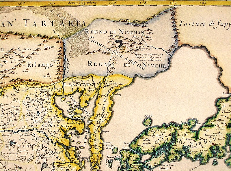
English: Northeastern fragment of a map of China (in Italian), showing the "Tartari del Kin o dell'Oro" (i.e., the Jin Tartars, or the Golden Tartars) populating the "Regno del Niulhan" (?) a.k.a. "Regno del Niuche" (i.e. the Kingdom of the Nüzhen, a.k.a Jurchen") who are further described as "The Tartars who have occupied, and at present are ruling, China". Further northeast, the "Tartari de Yupy" (i.e., "Fishskin Tartars" - the generic name of the Tungusic people of the Amur) are shown.
Italiano: "Il regno della China detto presentemente Catay e Mangin diuiso sopra le carte piu esatte nelle sue principali prouincie" |
| 日期 | Originally published 1682; the copy at HKUST is a 1689 reprint. |
| 來源 |
English: An antique map from the Special Collection "China in Maps" of the Hong Kong University of Science and Technology Library, reproduced by the HKUST Library in the book "China in European Maps", Hong Kong, 2003. ISBN 962-86403-9-9.
Русский: Старинная карта из специальной коллекции Библиотеки Гонконгского научно-технического университета. Опубликована этой библиотекой в книге "China in European Maps" (Китай на европейских картах), Гонконг, 2003. ISBN 962-86403-9-9, тиражом 1000 экз. См. также каталог выставки, Special Collection "China in Maps".
. Fragment of Plate 36: "Il regno della China detto presentemente Catay e Mangin diuiso sopra le carte piu esatte nelle sue principali prouincie" |
| 作者 | Giacomo Cantelli (1643-1695), Giovanni Giacomo de Rossi (1627-1691) |
| 其他版本 |
Entire map:  |
授權條款
[編輯]
|
此為如實地拍攝平面藝術品的相片複製本。原作位於公有領域,是因下列原因:
維基媒體基金會的官方立場認為:「針對平面公有領域的藝術作品進行忠實重製,其重製後的照片也屬於公有領域。」
因此,可認定本重製照片屬於公有領域。在其他司法管轄區,再利用此照片可能會被限制;參見再利用PD-Art照片以獲得進一步資訊。 | ||||
檔案歷史
點選日期/時間以檢視該時間的檔案版本。
| 日期/時間 | 縮圖 | 尺寸 | 用戶 | 備註 | |
|---|---|---|---|---|---|
| 目前 | 2013年8月12日 (一) 12:40 | | 1,600 × 1,186(1.07 MB) | Soerfm(對話 | 貢獻) | Crop, brightness |
| 2009年3月18日 (三) 04:06 |  | 1,600 × 1,200(1,024 KB) | Vmenkov(對話 | 貢獻) | {{Information |Description={{en|1=Northeastern fragment of a 1682 map of China (in Italian), showing the "Tartari del Kin o dell'Oro" (i.e., the Jin Tartars, or the Golden Tartars) populating the "Regno del Niulhan" (?) a.k.a. "Regno del Niuche" (i.e. the |
無法覆蓋此檔案。
檔案用途
下列3個頁面有用到此檔案:
全域檔案使用狀況
以下其他 wiki 使用了這個檔案:
- bcl.wikipedia.org 的使用狀況
- bg.wikipedia.org 的使用狀況
- en.wikipedia.org 的使用狀況
- es.wikipedia.org 的使用狀況
- fr.wikipedia.org 的使用狀況
- gl.wikipedia.org 的使用狀況
- gu.wikipedia.org 的使用狀況
- hy.wikipedia.org 的使用狀況
- id.wikipedia.org 的使用狀況
- la.wikipedia.org 的使用狀況
- nl.wikipedia.org 的使用狀況
- oc.wikipedia.org 的使用狀況
- pa.wikipedia.org 的使用狀況
- pnb.wikipedia.org 的使用狀況
- pt.wikipedia.org 的使用狀況
- ro.wikipedia.org 的使用狀況
- ru.wikipedia.org 的使用狀況
- uk.wikipedia.org 的使用狀況
- vi.wikipedia.org 的使用狀況
- war.wikipedia.org 的使用狀況
- zh.wikipedia.org 的使用狀況