File:CIA map Central America & Caribbean.png
Zur Navigation springen
Zur Suche springen

Greßi vu däre Vorschau: 798 × 599 Pixel. Wyteri Ufflösige: 320 × 240 Pixel | 639 × 480 Pixel | 1.023 × 768 Pixel | 1.280 × 961 Pixel | 1.390 × 1.044 Pixel.
Originaldatei (1.390 × 1.044 Pixel, Dateigrößi: 1,6 MB, MIME-Typ: image/png)
Bildtexte
Kurzbeschreibungen
Ergänze eine einzeilige Erklärung, was diese Datei darstellt.
JAY TAMBU MAYALA ENGANGE PAR LA CIA
Bschryybig[ändere]
| Bschryybig |
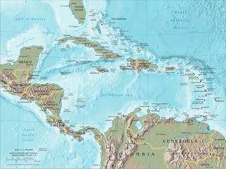
English: Map of Central America and the Caribbean by the CIA World Factbook Español: Mapa de Centroamérica y el Caribe en el CIA World Factbook |
| Quälle | Transferred from en.wikipedia to Commons. Original source is/was CIA The World Factbook |
| Urheber | U.S. Central Intelligence Agency (CIA) |
| Anderi Versione |


Lizänzierig[ändere]
Dieses Werk ist gemeinfrei, weil es Bildmaterial aus dem CIA World Factbook darstellt, das ursprünglich vom Zentralen Nachrichtendienst der Vereinigten Staaten veröffentlicht wurde.
|
 |
Orginal Logbuech vu uffegladene Datei[ändere]
The original description page was here. All following user names refer to en.wikipedia.
- 2007-09-20 19:45 Brianski 1392×1066×8 (1720810 bytes) == Summary == Map of [[Central America]], see https://www.cia.gov/library/publications/the-world-factbook/docs/refmaps.html. == License == {{PD-USGov-CIA-WF}}
Dateiversione
Klick uf e Zytpunkt zu aazeige, wie s dert usgsäh het.
| Version vom | Vorschaubild | Mäß | Benutzer | Kommentar | |
|---|---|---|---|---|---|
| aktuell | 22:22, 10. Jun. 2010 | | 1.390 × 1.044 (1,6 MB) | Jahoe (Diskussion | Byträg) | better compression (no visible alterations) |
| 08:45, 26. Aug. 2008 |  | 1.390 × 1.044 (2,3 MB) | Bowlhover (Diskussion | Byträg) | Cropped title. | |
| 22:01, 25. Sep. 2007 |  | 1.392 × 1.066 (1,64 MB) | Paintman (Diskussion | Byträg) | {{Information |Description=Map of en:Central America, see https://www.cia.gov/library/publications/the-world-factbook/docs/refmaps.html. |Source=Originally from [http://en.wikipedia.org en.wikipedia]; description page is/was [http://en.wikipedia.org |
Du chasch die Datei nit iberschryybe.
Verwändig vu dr Datei
Die 5 Syte bruuche die Datei:
.png&redirect=no)
Wältwyti Dateinutzig
Die andere Wikis bruche die Datei:
- Gebruch uf als.wikipedia.org
- Gebruch uf an.wikipedia.org
- Gebruch uf ar.wikipedia.org
- Gebruch uf ast.wikipedia.org
- Gebruch uf bat-smg.wikipedia.org
- Gebruch uf ba.wikipedia.org
- Gebruch uf bm.wikipedia.org
- Gebruch uf bn.wikipedia.org
- Gebruch uf bo.wikipedia.org
- Gebruch uf br.wikipedia.org
- Gebruch uf bs.wikipedia.org
- Gebruch uf co.wikipedia.org
- Gebruch uf cs.wikipedia.org
- Gebruch uf da.wikipedia.org
- Gebruch uf de.wikipedia.org
- Gebruch uf de.wiktionary.org
- Gebruch uf el.wikipedia.org
- Gebruch uf en.wikipedia.org
- Piracy in the Caribbean
- Portal:Latin America/Portals
- Wikipedia:WikiProject Caribbean
- Portal:Piracy/Selected article
- User:Saaristo
- Portal:Piracy/Selected article/10
- User:Zero Gravity/Proposal
- Ocean fisheries
- Wikipedia:Graphics Lab/Image workshop/Archive/Sep 2008
- Portal:Bolivia
- Portal:Bolivia/Related portals
- User:StAnMc18/sandbox
- Gebruch uf en.wikibooks.org
- Gebruch uf eo.wikipedia.org
- Gebruch uf es.wikipedia.org
- Gebruch uf eu.wikipedia.org
- Gebruch uf ext.wikipedia.org
- Gebruch uf fa.wikipedia.org
Wältwyti Verwändig vu däre Datei aaluege.
Kategorie:
- Maps of the Caribbean
- Maps of Central America
- Topographic maps of Nicaragua
- Topographic maps of Venezuela
- Topographic maps of Colombia
- Topographic maps of Panama
- Topographic maps of Costa Rica
- Topographic maps of El Salvador
- Topographic maps of Honduras
- Topographic maps of Guatemala
- Topographic maps of Belize
- Topographic maps of Mexico
- Topographic maps of Cuba
- Topographic maps of Jamaica
- Topographic maps of Haiti
- Topographic maps of the Dominican Republic
- Topographic maps of Puerto Rico