File:Cairns Airport.JPG
跳转到导航
跳转到搜索

本预览的尺寸:800 × 600像素。 其他分辨率:320 × 240像素 | 640 × 480像素 | 1,024 × 768像素 | 1,280 × 960像素 | 1,600 × 1,200像素。
原始文件 (1,600 × 1,200像素,文件大小:375 KB,MIME类型:image/jpeg)
说明
说明
添加一行文字以描述该文件所表现的内容
摘要
[编辑]
| 描述 |
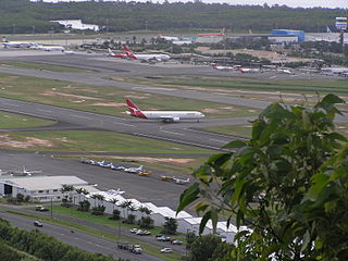
English: Cairns Airport looking north-east from a lookout on Mt. Whitfield. The en:Captain Cook Highway and en:General aviation area can be seen in foreground, with domestic and international terminals on the other side of the runway. Beyond the main terminal area is the Barron River, a en:mangrove swamp, and Trinity Bay in the en:Coral Sea. |
| 日期 | 2005年7月 (2005年6月17日, 根据EXIF的数据) |
| 来源 | Transferred from en.wikipedia to Commons by Sterkebak. |
| 作者 | 原上传者为英语维基百科的Adz |
许可协议
[编辑]
| 本文件采用知识共享署名-相同方式共享 3.0 未本地化版本许可协议授权。 受免責聲明的約束。 | ||
| ||
| 本许可协议标签作为GFDL许可协议更新的组成部分被添加至本文件。 |

|
已授权您依据自由软件基金会发行的无固定段落及封面封底文字(Invariant Sections, Front-Cover Texts, and Back-Cover Texts)的GNU自由文件许可协议1.2版或任意后续版本的条款,复制、传播和/或修改本文件。该协议的副本请见“GNU Free Documentation License”。 受免責聲明的約束。 |
原始上传日志
[编辑]
The original description page was here. All following user names refer to en.wikipedia.
- 2005-08-04 11:36 Adz 1600×1200×8 (383605 bytes) Cairns Airport looking east from a lookout on Mt. Whitfield. general aviation area can be seen in foreground, with domestic and international terminals to the eastern side of the main runway. Photo taken in July 2005. {{GFDL}}
文件历史
点击某个日期/时间查看对应时刻的文件。
| 日期/时间 | 缩略图 | 大小 | 用户 | 备注 | |
|---|---|---|---|---|---|
| 当前 | 2008年4月26日 (六) 13:12 | | 1,600 × 1,200(375 KB) | File Upload Bot (Magnus Manske)(留言 | 贡献) | {{BotMoveToCommons|en.wikipedia}} {{Information |Description={{en|Cairns Airport looking north-east from a lookout on Mt. Whitfield. The en:Captain Cook Highway and en:General aviation area can be seen in foreground, with domestic and internati |
您不可以覆盖此文件。
文件用途
以下页面使用本文件:
全域文件用途
以下其他wiki使用此文件:
- ast.wikipedia.org上的用途
- ceb.wikipedia.org上的用途
- de.wikivoyage.org上的用途
- en.wikipedia.org上的用途
- en.wikivoyage.org上的用途
- es.wikipedia.org上的用途
- es.wikinews.org上的用途
- fa.wikipedia.org上的用途
- fr.wikipedia.org上的用途
- gu.wikipedia.org上的用途
- hu.wikipedia.org上的用途
- it.wikivoyage.org上的用途
- ja.wikipedia.org上的用途
- kn.wikipedia.org上的用途
- ms.wikipedia.org上的用途
- nl.wikipedia.org上的用途
- pl.wikipedia.org上的用途
- ro.wikipedia.org上的用途
- ru.wikipedia.org上的用途
- sah.wikipedia.org上的用途
- sv.wikipedia.org上的用途
- tg.wikipedia.org上的用途
- vi.wikipedia.org上的用途
- www.wikidata.org上的用途
- zh.wikipedia.org上的用途