File:Calanque du Petit Canereit-Massif de l'Esterel.jpg
跳至導覽
跳至搜尋

預覽大小:800 × 450 像素。 其他解析度:320 × 180 像素 | 640 × 360 像素 | 1,024 × 576 像素 | 1,280 × 720 像素 | 2,560 × 1,440 像素 | 6,225 × 3,502 像素。
原始檔案 (6,225 × 3,502 像素,檔案大小:11.33 MB,MIME 類型:image/jpeg)
說明
說明
添加單行說明來描述出檔案所代表的內容
摘要
[編輯]
| 描述 |
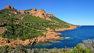
Français : The calanque du Petit Caneiret, à Anthéor près de Saint-Raphaël, au pied du Massif de l’Estérel sur la Côte d’Azur (Var, Provence-Alpes-Côte d’Azur, France).
English: The calanque (cliff bay) of Petit Caneiret, in Anthéor near Saint-Raphaël, which can be found at the foot of the Massif de l’Esterel in the French Riviera (Var, Provence-Alpes-Côte d’Azur, France).
Deutsch: Die Calanque (Felsbucht) von Petit Caneiret, bei Anthéor in der Nähe von Saint-Raphaël, die sich am Fuße des Massifs de l’Estérel befindet, bei der Côte d’Azur (Var, Provence-Alpes-Côte d’Azur, France). |
| 日期 | |
| 來源 | 自己的作品 |
| 作者 | Tobi 87 |
| 拍攝地點 | | 位於此地的本圖片與其他圖片: OpenStreetMap |
|---|

|
根據最有價值圖像標準,這張圖像被評定为在Massif de l'Esterel範疇內最有價值的共享資源圖像。你可以在Commons:Valued image candidates/Calanque du Petit Canereit-Massif de l'Esterel.jpg参看它的提名。 |
授權條款
[編輯]
我,本作品的著作權持有者,決定用以下授權條款發佈本作品:

|
已授權您依據自由軟體基金會發行的無固定段落、封面文字和封底文字GNU自由文件授權條款1.2版或任意後續版本,對本檔進行複製、傳播和/或修改。該協議的副本列在GNU自由文件授權條款中。 |
您可以選擇您需要的授權條款。
檔案歷史
點選日期/時間以檢視該時間的檔案版本。
| 日期/時間 | 縮圖 | 尺寸 | 用戶 | 備註 | |
|---|---|---|---|---|---|
| 目前 | 2011年10月2日 (日) 19:37 | | 6,225 × 3,502(11.33 MB) | Tobi 87(對話 | 貢獻) | {{Information |Description ={{en|1=Calanque (cliff bay) of Petit Canereit near Saint-Raphael, which could be find at the foot of the "Massif de l'Esterel"}} {{de|1=die Calanque (Felsbucht) von Petit Canereit in der Nähe von Saint-Raphael, die sich am |
無法覆蓋此檔案。
檔案用途
下列52個頁面有用到此檔案:
- Var
- User:Galdrad/Images-2011
- User:Samsara/POTY 2011 overview
- User:Tobi 87
- User:Zyephyrus/2012
- User:Ö/Best/2011
- User talk:Tobi 87
- Commons:Featured picture candidates/File:Calanque du Petit Canereit-Massif de l'Esterel.jpg
- Commons:Featured picture candidates/Log/October 2011
- Commons:Featured pictures/Places/Natural/France
- Commons:Featured pictures/chronological/2011-B
- Commons:Picture of the Year/2011/Galleries/2011-B
- Commons:Picture of the Year/2011/Galleries/ALL
- Commons:Picture of the Year/2011/Galleries/B
- Commons:Picture of the Year/2011/Galleries/B/table
- Commons:Picture of the Year/2011/Galleries/Index/10
- Commons:Picture of the Year/2011/Galleries/Index/11
- Commons:Picture of the Year/2011/Galleries/Index/ALL
- Commons:Picture of the Year/2011/Galleries/Index/Nature views
- Commons:Picture of the Year/2011/Galleries/Nature views
- Commons:Picture of the Year/2011/Galleries/Nature views/Large
- Commons:Picture of the Year/2011/Galleries/Nature views/Small
- Commons:Picture of the Year/2011/Galleries/OCT
- Commons:Picture of the Year/2011/Galleries/table
- Commons:Picture of the Year/2011/R1/Calanque du Petit Canereit-Massif de l'Esterel.jpg
- Commons:Picture of the Year/2011/Results/R1/ALL/table
- Commons:Picture of the Year/2011/Results/R1/Nature views
- Commons:Picture of the Year/2011/Results/R1/Nature views/table
- Commons:Quality images candidates/Archives October 2011
- Commons:Valued image candidates/Calanque du Petit Canereit-Massif de l'Esterel.jpg
- Commons:Valued images by topic/Places/Natural/Mountain sites
- Commons talk:Picture of the Year/2011/Results/R1/ALL/table
- File:Var banner.jpg
- Category:Archaeological sites in Var
- Category:Art of Var
- Category:Births in Var
- Category:Bridges in Var
- Category:Cemeteries in Var
- Category:Communautés d'agglomération in Var
- Category:Culture of Var
- Category:Deaths in Var
- Category:Dolmens in Var
- Category:Groups of communes in Var
- Category:Hospitals in Var
- Category:Lighthouses in Var
- Category:Maps of Var
- Category:People of Var
- Category:Rivers of Var
- Category:Routes nationales in Var
- Category:Town halls in Var
- Category:Var (department)
- Category:Views of Var
全域檔案使用狀況
以下其他 wiki 使用了這個檔案:
- ar.wikipedia.org 的使用狀況
- ast.wikipedia.org 的使用狀況
- az.wikipedia.org 的使用狀況
- ban.wikipedia.org 的使用狀況
- ca.wikipedia.org 的使用狀況
- ceb.wikipedia.org 的使用狀況
- ce.wikipedia.org 的使用狀況
- cs.wikipedia.org 的使用狀況
- cy.wikipedia.org 的使用狀況
- de.wikipedia.org 的使用狀況
- de.wikivoyage.org 的使用狀況
- el.wikipedia.org 的使用狀況
- en.wikipedia.org 的使用狀況
- en.wikivoyage.org 的使用狀況
- es.wikipedia.org 的使用狀況
- fr.wikipedia.org 的使用狀況
- fr.wikinews.org 的使用狀況
- fr.wikivoyage.org 的使用狀況
- gl.wikipedia.org 的使用狀況
- he.wikipedia.org 的使用狀況
- hy.wikipedia.org 的使用狀況
- ia.wikipedia.org 的使用狀況
- it.wikipedia.org 的使用狀況
- lld.wikipedia.org 的使用狀況
- nl.wikipedia.org 的使用狀況
- no.wikipedia.org 的使用狀況
- oc.wikipedia.org 的使用狀況
- os.wikipedia.org 的使用狀況
- pl.wikipedia.org 的使用狀況
- ro.wikipedia.org 的使用狀況
- ru.wikipedia.org 的使用狀況
- sq.wikipedia.org 的使用狀況
- sr.wikipedia.org 的使用狀況
- th.wikipedia.org 的使用狀況
- tr.wikipedia.org 的使用狀況
- uk.wikipedia.org 的使用狀況
- ur.wikipedia.org 的使用狀況
- vi.wikipedia.org 的使用狀況
- www.wikidata.org 的使用狀況
- zh.wikipedia.org 的使用狀況