File:California Freeway and Expressway System.svg
跳转到导航
跳转到搜索

此SVG文件的PNG预览的大小:514 × 600像素。 其他分辨率:206 × 240像素 | 411 × 480像素 | 658 × 768像素 | 878 × 1,024像素 | 1,755 × 2,048像素 | 576 × 672像素。
原始文件 (SVG文件,尺寸为576 × 672像素,文件大小:1.44 MB)
说明
说明
添加一行文字以描述该文件所表现的内容
摘要
[编辑]
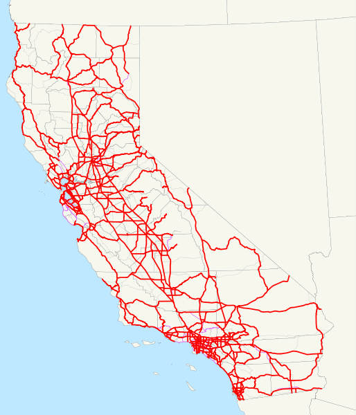
| 描述 | This is a map of the California Freeway and Expressway System; routes that have been removed from it are in thin purple, and other routes are very thin gray. Email me if you would like a copy of the GIS data I created for the highways. |
| 日期 | 2007年12月7日 (原始上传日期) |
| 来源 | 无法识别来源。根据版权声明推断为其自己的作品。 |
| 作者 | 无法识别作者。根据版权声明推断作者为NE2。 |
许可协议
[编辑]
| 我,本作品著作权人,释出本作品至公有领域。这适用于全世界。 在一些国家这可能不合法;如果是这样的话,那么: 我无条件地授予任何人以任何目的使用本作品的权利,除非这些条件是法律规定所必需的。 |
文件历史
点击某个日期/时间查看对应时刻的文件。
| 日期/时间 | 缩略图 | 大小 | 用户 | 备注 | |
|---|---|---|---|---|---|
| 当前 | 2008年1月6日 (日) 12:33 | | 576 × 672(1.44 MB) | NE2(留言 | 贡献) | Added all other routes to the background. |
| 2007年12月20日 (四) 03:52 |  | 576 × 672(1.4 MB) | NE2(留言 | 贡献) | Fixed SR 111 and SR 86 with respect to SR 86S. | |
| 2007年12月20日 (四) 03:43 |  | 576 × 672(1.4 MB) | NE2(留言 | 贡献) | Modified some positions. | |
| 2007年12月7日 (五) 00:07 |  | 576 × 672(1.32 MB) | NE2(留言 | 贡献) | Thinned the lines. | |
| 2007年12月7日 (五) 00:05 |  | 576 × 672(1.32 MB) | NE2(留言 | 贡献) | == Summary == This is a map of the California Freeway and Expressway System; routes that have been removed from it are in thin purple. Email me if you would like a copy of the GIS data I created for the highways. [[Category:Stat |
您不可以覆盖此文件。
文件用途
以下页面使用本文件:
全域文件用途
以下其他wiki使用此文件:
- en.wikipedia.org上的用途
- es.wikipedia.org上的用途
- www.wikidata.org上的用途
- zh.wikipedia.org上的用途