File:Cameroon CIA WFB 2006 map.png
Pumunta sa nabigasyon
Pumunta sa paghahanap
Wala na'ng mas malinaw.
Cameroon_CIA_WFB_2006_map.png (328 × 352 na pixel, laki: 10 KB, uri ng MIME: image/png)
Captions
Captions
Add a one-line explanation of what this file represents
Buod
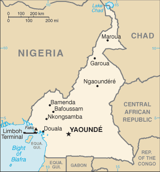
[baguhin]| Paglalarawan | Cameroon map from CIA World Factbook (since 10 Mayo 2006), converted from original GIF format |
| Petsa | |
| Pinanggalingan |
CIA World Factbook |
| May-akda | United States Central Intelligence Agency |
| Iba pang mga bersyon |
|
Paglilisensiya
[baguhin]This image is in the public domain because it contains materials that originally came from the United States Central Intelligence Agency's World Factbook.
|
 |
Derivative works
[baguhin]Derivatives of 2006 map:
-
 Mapa kamerunu.png
čeština

Derivatives of 2002 map:
-
 Camerunit.png
italiano -
 Carte cameroun francais.gif
français -
 Kameroenkaart.png
Afrikaans -
 000 Kameruni harta.PNG
 -
 Cameroon-map-blank.png


Derivatives of 2000 map:
-
 Southern cameroon map.JPG

Nakaraan ng file
Pindutin ang isang petsa/oras para makita ang file noong puntong yon.
| Petsa/Oras | Thumbnail | Sukat | Tagagamit | Komento | |
|---|---|---|---|---|---|
| ngayon | 06:34, 2 Setyembre 2011 | | 328 × 352 (10 KB) | Zyxw (usapan | ambag) | == {{int:filedesc}} == {{Information | Description = {{w|Cameroon}} map from CIA World Factbook ([http://web.archive.org/web/20060510034911/http://www.cia.gov/cia/publications/factbook/geos/cm.html since {{date|2006|05|10}}]), converted from original {{w| |
Hindi mo mao-overwrite ang file na ito.
Paggamit sa file
Walang pahinang gumagamit sa file na ito.
Pandaigdigang paggamit sa file
Ginagamit ng mga sumusunod na wiki ang file na ito:
- Paggamit sa bn.wikipedia.org
- Paggamit sa bs.wikipedia.org
- Paggamit sa ca.wikipedia.org
- Paggamit sa en.wikipedia.org
- Paggamit sa eo.wikipedia.org
- Paggamit sa fa.wikipedia.org
- Paggamit sa fi.wikipedia.org
- Paggamit sa fr.wikipedia.org
- Paggamit sa ilo.wikipedia.org
- Paggamit sa ja.wikipedia.org
- Paggamit sa kn.wikipedia.org
- Paggamit sa ml.wikipedia.org
- Paggamit sa simple.wikipedia.org
- Paggamit sa si.wikipedia.org
- Paggamit sa sl.wikipedia.org
- Paggamit sa sn.wikipedia.org
- Paggamit sa th.wikipedia.org
- Paggamit sa tl.wikipedia.org
- Paggamit sa uz.wikipedia.org
- Paggamit sa zh.wikipedia.org