File:Canada2.A2002165.1940.250m.jpg
Aller à la navigation
Aller à la recherche

Taille de cet aperçu : 461 × 599 pixels. Autres résolutions : 184 × 240 pixels | 369 × 480 pixels | 591 × 768 pixels | 788 × 1 024 pixels | 1 575 × 2 048 pixels | 4 000 × 5 200 pixels.
Fichier d’origine (4 000 × 5 200 pixels, taille du fichier : 2,83 Mio, type MIME : image/jpeg)
Légendes
Légendes
Ajoutez en une ligne la description de ce que représente ce fichier
Description
[modifier]
| Description |
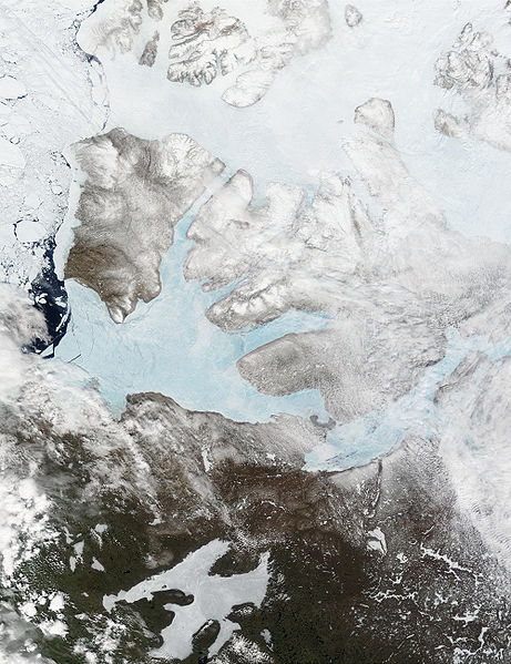
English: These Moderate resolution Imaging Spectroradiometer Images from June 14 and 16, 2002, show Banks Island (upper left) and Victoria Island (to the southeast) in the Arctic Ocean off northwest Canada. Left of center in each image is Amundsen Gulf, looking bright blue as this arm of the Beaufort Sea (at the southern end of the Arctic Ocean) begins to thaw. At the bottom of the images, the tundra of the Northwest Territories (left) and the Nunavut (right) Provinces of Canada is beginning to lose its winter snow cover. At bottom center of the portrait oriented image is Great Bear lake--still frozen. |
| Date | June 14 and 16, 2002 |
| Source | http://visibleearth.nasa.gov/view_rec.php?id=3342 |
| Auteur | Jacques Descloitres, MODIS Land Rapid Response Team, NASA/GSFC |
Conditions d’utilisation
[modifier]
| Ce fichier provient de la NASA. Sauf exception, les documents créés par la NASA ne sont pas soumis à copyright. Pour plus d'informations, voir la politique de copyright de la NASA. | ||
 |
Attention :
|
Historique du fichier
Cliquer sur une date et heure pour voir le fichier tel qu'il était à ce moment-là.
| Date et heure | Vignette | Dimensions | Utilisateur | Commentaire | |
|---|---|---|---|---|---|
| actuel | 20 août 2008 à 17:59 | | 4 000 × 5 200 (2,83 Mio) | Ando228 (d | contributions) | {{Information |Description={{en|1=These Moderate resolution Imaging Spectroradiometer Images from June 14 and 16, 2002, show Banks Island (upper left) and Victoria Island (to the southeast) in the Arctic Ocean off northwest Canada. Left of center in each |
Vous ne pouvez pas remplacer ce fichier.
Utilisations locales du fichier
Les 27 pages suivantes utilisent ce fichier :
- Northwest Territories - Territoires du Nord-Ouest
- Category:1936 in the Northwest Territories
- Category:1939 in the Northwest Territories
- Category:Births in the Northwest Territories
- Category:Bridges in the Northwest Territories
- Category:Lakes of the Northwest Territories
- Category:Maps of the Northwest Territories
- Category:Northwest Territories
- Category:Northwest Territories in the 1880s
- Category:Northwest Territories in the 1890s
- Category:Northwest Territories in the 1900s
- Category:Northwest Territories in the 1920s
- Category:Northwest Territories in the 1930s
- Category:Northwest Territories in the 1940s
- Category:Northwest Territories in the 1950s
- Category:Northwest Territories in the 1960s
- Category:Northwest Territories in the 1970s
- Category:Northwest Territories in the 1980s
- Category:Northwest Territories in the 1990s
- Category:Northwest Territories in the 19th century
- Category:Northwest Territories in the 2000s
- Category:Northwest Territories in the 2010s
- Category:Northwest Territories in the 2020s
- Category:Northwest Territories in the 20th century
- Category:Northwest Territories in the 21st century
- Category:People of the Northwest Territories
- Category:Populated places in the Northwest Territories
Utilisations du fichier sur d’autres wikis
Les autres wikis suivants utilisent ce fichier :
- Utilisation sur af.wikipedia.org
- Utilisation sur ar.wikipedia.org
- Utilisation sur ast.wikipedia.org
- Utilisation sur az.wikipedia.org
- Utilisation sur be.wikipedia.org
- Utilisation sur bg.wikipedia.org
- Utilisation sur bn.wikipedia.org
- Utilisation sur ca.wikipedia.org
- Utilisation sur ceb.wikipedia.org
- Utilisation sur cy.wikipedia.org
- Utilisation sur da.wikipedia.org
- Utilisation sur de.wikivoyage.org
- Utilisation sur diq.wikipedia.org
- Utilisation sur en.wikipedia.org
- Utilisation sur es.wikipedia.org
- Utilisation sur eu.wikipedia.org
- Utilisation sur fa.wikipedia.org
- Utilisation sur fi.wikipedia.org
- Utilisation sur fr.wikipedia.org
- Utilisation sur fr.wikivoyage.org
- Utilisation sur fy.wikipedia.org
- Utilisation sur ga.wikipedia.org
- Utilisation sur gl.wikipedia.org
- Utilisation sur he.wikipedia.org
- Utilisation sur hu.wikipedia.org
- Utilisation sur hy.wikipedia.org
- Utilisation sur ilo.wikipedia.org
- Utilisation sur is.wikipedia.org
- Utilisation sur it.wikipedia.org
- Utilisation sur ja.wikipedia.org
- Utilisation sur ko.wikipedia.org
- Utilisation sur ku.wikipedia.org
- Utilisation sur la.wikipedia.org
- Utilisation sur lv.wikipedia.org
- Utilisation sur ml.wikipedia.org
- Utilisation sur mzn.wikipedia.org
- Utilisation sur nl.wikipedia.org
- Utilisation sur nn.wikipedia.org
Voir davantage sur l’utilisation globale de ce fichier.