File:Canada provinces 1870-1871.png
跳转到导航
跳转到搜索

本预览的尺寸:694 × 600像素。 其他分辨率:278 × 240像素 | 556 × 480像素 | 1,000 × 864像素。
原始文件 (1,000 × 864像素,文件大小:58 KB,MIME类型:image/png)
说明
说明
添加一行文字以描述该文件所表现的内容
Dels reign

|
此historical map图片可使用矢量图形重新创建为SVG文件。这具有很多好处;更多信息请参见共享资源:待清理媒体。如果存在此图片的SVG格式,请将其上传,然后将此模板替换为
{{vector version available|新图片名称}}。
建议您将SVG命名为“Canada provinces 1870-1871.svg”,这样在使用Vector version available(或Vva)模板时就不需要填写新图片名称参数。 |
摘要[编辑]
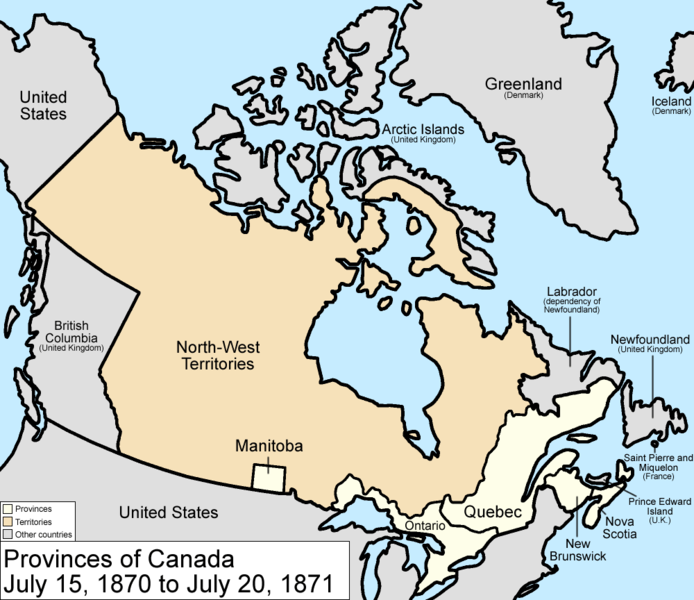
Map of the provinces and territories of Canada as they were from 1870 to 1871. On July 15 1870, Rupert's Land and the North-Western Territory were ceded to Canada, and became the North-West Territories; a small square of this was made into the province of Manitoba. On July 20 1871, British Columbia joined as a province.
Made by User:Golbez.
许可协议[编辑]
我,本作品著作权人,特此采用以下许可协议发表本作品:

|
已授权您依据自由软件基金会发行的无固定段落及封面封底文字(Invariant Sections, Front-Cover Texts, and Back-Cover Texts)的GNU自由文件许可协议1.2版或任意后续版本的条款,复制、传播和/或修改本文件。该协议的副本请见“GNU Free Documentation License”。 |
| 本文件采用知识共享署名-相同方式共享 3.0 未本地化版本许可协议授权。 | ||
| ||
| 本许可协议标签作为GFDL许可协议更新的组成部分被添加至本文件。 |
您可以选择您需要的许可协议。
文件历史
点击某个日期/时间查看对应时刻的文件。
| 日期/时间 | 缩略图 | 大小 | 用户 | 备注 | |
|---|---|---|---|---|---|
| 当前 | 2009年7月14日 (二) 17:17 | | 1,000 × 864(58 KB) | Golbez(留言 | 贡献) | New color scheme, other borders |
| 2007年3月13日 (二) 18:53 |  | 1,000 × 864(46 KB) | Golbez(留言 | 贡献) | Fix date | |
| 2006年8月7日 (一) 09:59 |  | 1,000 × 864(46 KB) | Golbez(留言 | 贡献) | with legend | |
| 2006年2月18日 (六) 02:24 |  | 1,000 × 864(45 KB) | Golbez(留言 | 贡献) | Better version | |
| 2006年2月13日 (一) 23:42 |  | 950 × 725(26 KB) | Golbez(留言 | 贡献) | Map of the provinces of Canada as they were from 1870 to 1871. On July 15 1870, Rupert's Land and were ceded to Canada, and became the North-West Territories; a small square of this was made into the province of Manitoba. On July 20 1871, British Columbia |
您不可以覆盖此文件。
文件用途
全域文件用途
以下其他wiki使用此文件:
- cs.wikipedia.org上的用途
- de.wikipedia.org上的用途
- en.wikipedia.org上的用途
- Red River Rebellion
- North-Western Territory
- Rupert's Land Act 1868
- Louis Riel (comics)
- History of Saskatchewan
- User:Tompw/sandbox3
- Wikipedia:Graphics Lab/Map workshop/Archive/Jun 2009
- 1871 Canadian census
- Timeline of Rupert's Land and North-Western Territory transfer
- Deed of Surrender
- User:Falcaorib/Canada, United States and Mexico
- es.wikipedia.org上的用途
- fi.wikipedia.org上的用途
- fr.wikipedia.org上的用途
- fr.wiktionary.org上的用途
- fy.wikipedia.org上的用途
- he.wikipedia.org上的用途
- hy.wikipedia.org上的用途
- it.wikipedia.org上的用途
- lt.wikipedia.org上的用途
- no.wikipedia.org上的用途
- pt.wikipedia.org上的用途
- ru.wikipedia.org上的用途
- sh.wikipedia.org上的用途
- sr.wikipedia.org上的用途
- sv.wikipedia.org上的用途
- uk.wikipedia.org上的用途
- vi.wikipedia.org上的用途
- zh.wikipedia.org上的用途